Petone
Petone (/pɛˈtoʊni/, Māori: Pito-one), a large suburb of Lower Hutt in the Wellington Region of New Zealand's North Island, stands at the southern end of the Hutt Valley, on the northern shore of Wellington Harbour. The Māori name Pito-one means "end of the sand beach".[2]
Petone | |
|---|---|
Suburb | |
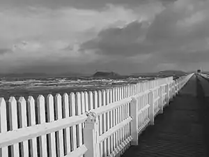 Petone Wharf on a stormy day | |
 Petone | |
| Coordinates: 41°13′30.00″S 174°52′40.80″E | |
| Country | New Zealand |
| Local authority | Hutt City |
| Electoral ward | Harbour |
| Established | 1840 |
| Population (2013 census)[1] | |
| • Total | 6,756 |
| Postcode(s) | 5012 |
| Train station(s) | Petone Railway Station Ava Railway Station |
| Korokoro | Maungaraki | Alicetown |
| Horokiwi |
|
Moera |
| Wellington Harbour | Seaview |
Europeans first settled in Petone in 1840, making it one of the oldest settlements in the Wellington Region. It became a borough in 1888, and merged with Lower Hutt (branded as "Hutt City") in 1989.
History
A substantial Maori pā (fortified settlement) was already established at Pito-one close to the beach when the first European settlers arrived in the region. The first European settlers in large numbers arrived on 22 January 1840, on the ship Aurora[3] carrying 25 married couples, 36 single persons and 40 children.
The locality was described as, "sandy beach, which is about two miles long ... bounded on either side by wooded hills from 300 to 400 feet in height. It was covered in high forest to within a mile and a half of the beach, when swamps full of flax (New Zealand flax) and a belt of sand hummocks intervened." The Maori from the nearby pa came to meet them, one passenger's diary recording, "the venerable old chief Te Puni ... together with sons and endless relatives and a pa full of natives who were delighted to greet us with 'Kapai-te-Pakeha' and other expressions of greeting".
A beach settlement of small wooden houses and tents was established, which was initially called Britannia. The earliest European settlers found life hard. Nevertheless, the settlement grew: the population of "Pito-one and Hutt" in 1845 was given as 649, compared to, "Town of Wellington" of 2,667. In 1850 the Maori pa at Pito-one was described as, "the largest and best fortified within the District of Wellington ... their cultivations of kumara and maize look well and the residents, in point of comfort and wealth, are better off than any of the Port Nicholson natives ... total population 136." There was horse racing at Pito-one Beach on 20 October 1842, attracting a crowd of five or six hundred people from Wellington.[4]
Petone was the first European settlement in the Wellington region and retains many historical buildings and landmarks. After repeated flooding, settlers moved south to Thorndon.[5] Thorndon is at the shore of what is now the city of Wellington, New Zealand's capital.
For much of the 20th century, Petone was a thriving, largely working-class town and the location of several large industrial sites, including two car assembly plants, a meat processing plant, a wool processing plant, a tobacco processing plant,[6] a soap factory and a toothpaste factory.[7] One remnant of this industrial history is the Petone Wharf. The wharf was originally built to allow the Gear Meat Works to export its products.[8] The majority of these closed in the 1970s and 1980s, particularly after the . resulting in gradual economic decline.
Petone gained borough status in 1888. Petone Borough[9] amalgamated with Lower Hutt as a result of the local government reform in 1989.
The suburb has since enjoyed renewed economic growth, using its early European heritage as a draw for tourists and gaining many cafes and shops.
It is home of the Petone Rugby Club which has been one of the world's leading clubs since 1885.
State housing
Some of New Zealand's first State housing was constructed in Petone in 1906, with some of the original houses remaining in good condition. The local tourist office provides a guide showing where these houses are located.
Geography
Petone is relatively flat lies at the river mouth of the Hutt River. It nestled between the river to the north, hills on the west and east and Wellington Harbour to the south.
As a low-lying suburb, it is vulnerable to tsunami[10] and the threat of flooding.
Notable features
- The Te Puna Wai Ora (Spring of Life) in Buick Street provides pure untreated artesian (underground pressured) water from taps. The water originates from the Hutt River at the Taita Gorge and is safe to drink in its natural form as it has been naturally filtered through the alluvial gravels and sands of the Hutt Valley over several years. It is free, highly valued and consumers travel long distances to collect the water for drinking purposes.[11]
- Petone Community Library (Te Kete Wananga) access via Jackson Street.
- Petone Settlers Museum, housed in the Wellington Provincial Centennial Memorial Building on the Petone foreshore.
- Honiana Te Puni-kokopu New Zealand Wars memorial in the Te Puni Street urūpa (burial ground).[12]
Petone Rotary Fair

The Petone Rotary Fair is a notable local event, held annually since 1992, that draws people from all over the greater Wellington region to Jackson Street, Petone's main thoroughfare, which is closed off to traffic.
The purpose of the fair is not only to raise the profile of Petone and provide an enjoyable day out, but to raise money for charity. The fair consists of various stalls selling everything from plants, artwork, jewellery, CDs & DVDs, cosmetics, food and drink, etc., as well as musicians, carnival rides, and displays from various organisations such as the New Zealand Fire Service.
Education
Petone has three schools
- Petone Central School is a state full primary (Year 1–8) school in central Petone, and has 74 students as of March 2020.[13]
- Sacred Heart School is a state-integrated Catholic full primary (Year 1–8) school in central Petone, and has 145 students as of March 2020.[13]
- Wilford School is a state full primary (Year 1–8) school in northeastern Petone, and has 304 students as of March 2020.[13]
Since Petone College closed in 1998, Hutt Valley High School in central Lower Hutt has been the nearest state secondary school to Petone.
The main campus of the Wellington Institute of Technology (Weltec) is located in Petone.
References
| Wikimedia Commons has media related to Petone. |
- Combined population of Petone Central, Esplanade and Wilford area units. "2013 Census map – QuickStats about a place". Statistics New Zealand. Archived from the original on 22 August 2015. Retrieved 26 July 2015.
- Te Ara: The encyclopaedia of New Zealand – Hutt Valley – south Retrieved: 13 January 2009 – "The first European immigrants settled at Pito-one (‘the end of the sand beach’), now known as Petone."
- "First European settlers arrive in Wellington". 22 October 2013.
- "Early Wellington" compiled by Louis E. Ward, Whitcomb and Tombs Ltd 1929.
- "Petone". nzhistory.govt.nz. Retrieved 7 May 2020.
... flooding led many settlers to leave Petone for a new site at Thorndon.
- "Imperial Tobacco plans to close Petone factory". Stuff. Retrieved 7 May 2020.
A spokeswoman, Louise Evans McDonald, said Imperial had owned the factory since the late 1990s, but the site itself had been used for making tobacco products since 1919, initially under the name WD & HO Wills.
- "Another blow to Hutt City's business sector". NZ Herald. 1 November 2006. ISSN 1170-0777. Retrieved 7 May 2020.
After more the 50 years of operating and despite turning a profit, the Colgate Palmolive factory in Petone is closing next year, bringing the loss of around 100 jobs.
- "Petone Foreshore". www.huttcity.govt.nz. Hutt City Council. Retrieved 7 May 2020.
- "Petone Borough". NZGB Gazetteer. LINZ. Retrieved 7 May 2020.
- "Petone Alicetown Tsunami Map" (PDF). Wellington Region Emergency Management Office. Retrieved 7 May 2020.
- Hutt City – Petone's Artesian Water Archived 13 May 2010 at the Wayback Machine Retrieved: 5 April 2012
- "Honiana Te Puni NZ Wars memorial". NZ History. Ministry for Culture and Heritage. Retrieved 19 July 2017.
- "New Zealand Schools Directory". New Zealand Ministry of Education. Retrieved 26 April 2020.