May Sho'ate
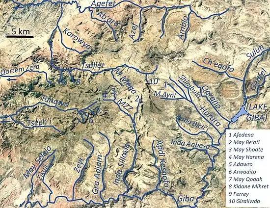
May Sho’ate (also called Argak'a) is a river of the Nile basin. Rising in the mountains of Dogu’a Tembien in northern Ethiopia, it flows southward to empty finally in Giba and Tekezé River.[1]
| May Sho’ate | |
|---|---|
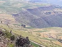
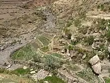
.jpg.webp) The May Sho’ate River in its catchment | |
 May Sho’ate River in Dogu’a Tembien | |
| Location | |
| Country | Ethiopia |
| Region | Tigray Region |
| District (woreda) | Dogu’a Tembien |
| Physical characteristics | |
| Source | May Ntebteb |
| • location | Zenaqo in Ayninbirkekin municipality |
| • elevation | 2,500 m (8,200 ft) |
| Mouth | May Zegzeg River |
• location | May Addi Abagie, at the border of Mika'el Abiy and Haddinnet municipalities |
• coordinates | 13.644°N 39.194°E |
• elevation | 2,270 m (7,450 ft) |
| Length | 1.9 km (1.2 mi) |
| Width | |
| • average | 5 m (16 ft) |
| Basin features | |
| River system | Seasonal/permanent river |
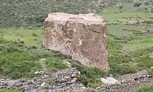
| Landmarks | Ilias’ Stone |
| Waterfalls | May Ntebteb |
| Topography | Mountains and deep gorges |
Characteristics
It is a confined ephemeral river with an average slope gradient of 121 metres per kilometre. With its tributaries, the river has cut a deep gorge.[2]
May Zegzeg Integrated Catchment Management Project
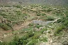
As part of outreach accompanying research in Dogu'a Tembien, the May Zegzeg Integrated Catchment Management Project was set up in 2004 in the catchment of the May Zegzeg River by researchers in cooperation with ADCS, a local NGO. There was a particular focus on the May Sho’ate subcatchment.The project included the implementation of conservation techniques to increase water infiltration and conserve the soil. The objective was to improve the livelihood of the communities of Harena, Hech'i and Addi Qolqwal as well as to demonstrate and promote global catchment management in the district.[3] The results of the implementation of site-specific conservation techniques aimed at increasing water infiltration and conserving soil were particularly monitored in the headwaters at May Sho'ate: dry masonry stone bunds,[4] check dams in gullies,[5] and the set-aside of degraded rangelands which resulted in exclosures.[6]
Flash floods and flood buffering
Runoff mostly happens in the form of high runoff discharge events that occur in a very short period (called flash floods). These are related to the steep topography, often little vegetation cover and intense convective rainfall. The peaks of such flash floods have often a 50 to 100 times larger discharge than the preceding baseflow.[2]
The magnitude of floods in this river has however been decreased due to interventions in the catchment by the May Zegzeg project, and other community activities. On the steep slopes, exclosures have been established; the dense vegetation largely contributes to enhanced infiltration, less flooding and better baseflow.[7] Physical conservation structures such as stone bunds[8][9] and check dams also intercept runoff.[10][11]
Irrigated agriculture
Besides springs and reservoirs, irrigation is strongly dependent on the river's baseflow. Such irrigated agriculture is important in meeting the demands for food security and poverty reduction.[2] Irrigated lands near springs that became strong after conservation activities: [1]
- Zenaqo in the upper catchment
- May Addi Abagiè, near the confluence of May Sho’ate and May Harena
Boulders and pebbles in the river bed
Boulders and pebbles encountered in the river bed can originate from any location higher up in the catchment. In the uppermost stretches of the river, only rock fragments of the upper lithological units will be present in the river bed, whereas more downstream one may find a more comprehensive mix of all lithologies crossed by the river. From upstream to downstream, the following lithological units occur in the catchment.[12]
Research catchment
Given its representativeness for the wider northern Ethiopian Highlands and the proximity to Hagere Selam town, various research undertakings took place along May Sho’ate and in its catchment. These studies were particularly related to:
- Contribution of tillage erosion to landscape formation (monitoring study)[13]
- Removal of rock fragments and its effect on soil loss and crop yield (study on experimental plots)[14]
- Remobilisation of ancient mass movements (the May Ntebteb landslide)[15]
- Impact of road building on gully erosion risk[16]
- Causes of high stone cover in farm fields [17]
- Effectiveness of loose rock check dams for gully control (monitoring study) [18]
- Effectiveness of stone bunds in controlling soil erosion (monitoring studies)[19][20]
- Rainfall erosivity and variability (based on rain data collection) [21]
- Impacts of soil conservation on soil fertility and crop yield (monitoring study)[22]
- Rockfall from the cliffs in the catchment and rock fragment displacement on scree slopes (monitoring study) [23]
- Soil mapping[24]
- River sediment budget before and after land conservation[25][26]
- Groundwater recharge monitoring[27][28]
- Conservation agriculture (studies on experimental plots and in farmers fields) [29][30][31][32][33][34]
- Land use and soil erosion rates (study on experimental plots) [35]
- Water balance (monitoring study)[36]
- Rodents harbouring in loose rock conservation structures[37]
Natural boundary
During its course, this river constitutes the borders between Ayninbirkekin and Mika'el Abiy municipalities|.[1]
Trekking along the river
Trekking routes have been established across and along this river.[38] The tracks are not marked on the ground but can be followed using downloaded .GPX files.[39]
- Trek 12, across the river and its upper catchment near Addi Qolqwal village
- Trek 12V, across the river and its lower catchment near Hech'i and Harena villages
See also
- List of Ethiopian rivers
References
- Jacob, M. and colleagues (2019). Geo-trekking map of Dogu'a Tembien (1:50,000). In: Geo-trekking in Ethiopia's Tropical Mountains - The Dogu'a Tembien District. SpringerNature. ISBN 978-3-030-04954-6.
- Amanuel Zenebe, and colleagues (2019). The Giba, Tanqwa and Tsaliet rivers in the headwaters of the Tekezze basin. In: Geo-trekking in Ethiopia's Tropical Mountains - The Dogu'a Tembien District. SpringerNature. doi:10.1007/978-3-030-04955-3_14. ISBN 978-3-030-04954-6.
- Reubens, B. and colleagues (2019). Research-based development projects in Dogu'a Tembien. In: Geo-trekking in Ethiopia's Tropical Mountains - The Dogu'a Tembien District. SpringerNature. ISBN 978-3-030-04954-6.
- Nyssen, Jan; Poesen, Jean; Gebremichael, Desta; Vancampenhout, Karen; d'Aes, Margo; Yihdego, Gebremedhin; Govers, Gerard; Leirs, Herwig; Moeyersons, Jan; Naudts, Jozef; Haregeweyn, Nigussie; Haile, Mitiku; Deckers, Jozef (2007). "Interdisciplinary on-site evaluation of stone bunds to control soil erosion on cropland in Northern Ethiopia" (PDF). Soil and Tillage Research. 94 (1): 151–163. doi:10.1016/j.still.2006.07.011. hdl:1854/LU-378900.
- Nyssen, J.; Veyret-Picot, M.; Poesen, J.; Moeyersons, J.; Haile, Mitiku; Deckers, J.; Govers, G. (2004). "The effectiveness of loose rock check dams for gully control in Tigray, Northern Ethiopia". Soil Use and Management. 20: 55–64. doi:10.1111/j.1475-2743.2004.tb00337.x.
- Descheemaeker, K. and colleagues (2006). "Sediment deposition and pedogenesis in exclosures in the Tigray Highlands, Ethiopia". Geoderma. 132 (3–4): 291–314. doi:10.1016/j.geoderma.2005.04.027.
- Descheemaeker, K. and colleagues (2006). "Runoff on slopes with restoring vegetation: A case study from the Tigray highlands, Ethiopia". Journal of Hydrology. 331 (1–2): 219–241. doi:10.1016/j.still.2006.07.011.
- Nyssen, Jan; Poesen, Jean; Gebremichael, Desta; Vancampenhout, Karen; d'Aes, Margo; Yihdego, Gebremedhin; Govers, Gerard; Leirs, Herwig; Moeyersons, Jan; Naudts, Jozef; Haregeweyn, Nigussie; Haile, Mitiku; Deckers, Jozef (2007). "Interdisciplinary on-site evaluation of stone bunds to control soil erosion on cropland in Northern Ethiopia" (PDF). Soil and Tillage Research. 94 (1): 151–163. doi:10.1016/j.still.2006.07.011. hdl:1854/LU-378900.
- Gebeyehu Taye and colleagues (2015). "Evolution of the effectiveness of stone bunds and trenches in reducing runoff and soil loss in the semi-arid Ethiopian highlands". Zeitschrift für Geomorphologie. 59 (4): 477–493. doi:10.1127/zfg/2015/0166.
- Nyssen, J.; Veyret-Picot, M.; Poesen, J.; Moeyersons, J.; Haile, Mitiku; Deckers, J.; Govers, G. (2004). "The effectiveness of loose rock check dams for gully control in Tigray, Northern Ethiopia". Soil Use and Management. 20: 55–64. doi:10.1111/j.1475-2743.2004.tb00337.x.
- Etefa Guyassa and colleagues (2017). "Effects of check dams on runoff characteristics along gully reaches, the case of Northern Ethiopia". Journal of Hydrology. 545 (1): 299–309. doi:10.1016/j.jhydrol.2016.12.019. hdl:1854/LU-8518957.
- Sembroni, A.; Molin, P.; Dramis, F. (2019). Regional geology of the Dogu'a Tembien massif. In: Geo-trekking in Ethiopia's Tropical Mountains — The Dogu'a Tembien District. SpringerNature. ISBN 978-3-030-04954-6.
- Tillage erosion on slopes with soil conservation structures in the Ethiopian highlands
- Removal of rock fragments and its effect on soil loss and crop yield, Tigray, Ethiopia
- The environmental significance of the remobilisation of ancient mass movements in the Atbara–Tekeze headwaters, Northern Ethiopia
- Impact of road building on gully erosion risk: a case study from the Northern Ethiopian Highlands
- Spatial distribution of rock fragments in cultivated soils in northern Ethiopia as affected by lateral and vertical displacement processes
- Nyssen, J.; Veyret-Picot, M.; Poesen, J.; Moeyersons, J.; Haile, Mitiku; Deckers, J.; Govers, G. (2004). "The effectiveness of loose rock check dams for gully control in Tigray, Northern Ethiopia". Soil Use and Management. 20: 55–64. doi:10.1111/j.1475-2743.2004.tb00337.x.
- Nyssen, Jan; Poesen, Jean; Gebremichael, Desta; Vancampenhout, Karen; d'Aes, Margo; Yihdego, Gebremedhin; Govers, Gerard; Leirs, Herwig; Moeyersons, Jan; Naudts, Jozef; Haregeweyn, Nigussie; Haile, Mitiku; Deckers, Jozef (2007). "Interdisciplinary on-site evaluation of stone bunds to control soil erosion on cropland in Northern Ethiopia" (PDF). Soil and Tillage Research. 94 (1): 151–163. doi:10.1016/j.still.2006.07.011. hdl:1854/LU-378900.
- Desta Gebremichael, Nyssen, J., Poesen, J., Deckers, J., Mitiku Haile, Govers, G., Moeyersons, J., 2005. Effectiveness of stone bunds in controlling soil erosion on cropland in the Tigray highlands, Northern Ethiopia. Soil Use & Management, 21(3): 287-297
- Rainfall erosivity and variability in the Northern Ethiopian Highlands
- Vancampenhout, K., Nyssen, J., Desta Gebremichael, Deckers, J., Poesen, J., Mitiku Haile, Moeyersons, J., 2006. Stone bunds for soil conservation in the northern Ethiopian highlands: Impacts on soil fertility and crop yield. Soil and Tillage Research, 90: 1-15
- Processes and rates of rock fragment displacement on cliffs and scree slopes in an amba landscape, Ethiopia
- Nyssen, J.; Naudts, J.; De Geyndt, K.; Haile, Mitiku; Poesen, J.; Moeyersons, J.; Deckers, J. (2008). "Soils and land use in the Tigray highlands (Northern Ethiopia)". Land Degradation and Development. 19 (3): 257–274. doi:10.1002/ldr.840.
- Dynamics of soil erosion rates and controlling factors in the Northern Ethiopian Highlands – towards a sediment budget
- How soil conservation affects the catchment sediment budget – a comprehensive study in the north Ethiopian highlands
- Vandecasteele, I., Nyssen, J., Clymans, W., Moeyersons, J., Martens, K., Van Camp, M., Tesfamichael Gebreyohannes, Desmedt, F., Deckers, J., Walraevens, K., 2011. Hydrogeology and groundwater flow in a basalt-capped Mesozoic sedimentary series of the Ethiopian highlands. Hydrogeology Journal, 19(3): 641-650
- Walraevens, K., Vandecasteele, I., Martens, K., Nyssen, J., Moeyersons, J., Tesfamichael Gebreyohannes, De Smedt, F., Poesen, J., Deckers, J., Van Camp, M., 2009. Groundwater recharge and flow in a small mountain catchment in Northern Ethiopia. Hydrological Sciences Journal, 54: 739-753
- The use of the marasha ard plough for conservation agriculture in Northern Ethiopia
- Tesfay Araya, Nyssen, J., Govaerts, B., Baudron, F., Carpentier, L., Bauer, H., Lanckriet, S., Deckers, J., Cornelis, W. M., 2016. Restoring cropland productivity and profitability in northern Ethiopian drylands after nine years of resource-conserving agriculture. Experimental Agriculture, 52(2): 165-187
- Lanckriet, S., Tesfay Araya, Derudder, B., Cornelis, W., Bauer, H., Govaerts, B., Deckers, J., Mitiku Haile, Naudts, J., Nyssen, J., 2014. Toward practical implementation of Conservation Agriculture: a case study in the May Zeg-zeg catchment (Ethiopia). Agroecology and Sustainable Food Systems, 38: 913–935
- Lanckriet, S., Tesfay Araya, Cornelis, W., Verfaillie, E., Poesen, J., Govaerts, B., Bauer, H., Deckers, S., Mitiku Haile, Nyssen, J., 2012. Impacts of conservation agriculture on runoff and soil loss under changing climate conditions in May Zeg-zeg (Ethiopia). Journal of Hydrology, 475: 336-349
- Tesfay Araya, Cornelis, W.M., Nyssen, J., Govaerts, B., Bauer, H., Tewodros Gebregziabher, Tigist Oicha, Raes, D., Sayre, K.D., Mitiku Haile, Deckers, J., 2011. Effects of conservation agriculture on runoff, soil loss and crop yield under rain fed conditions in Tigray, Northern Ethiopia. Soil Use and Management, 27(3): 404–414
- Tewodros Gebreegziabher, Nyssen, J., Govaerts, B., Fekadu Getnet, Mintesinot Behailu, Mitiku Haile, Deckers, J., 2009. Contour furrows for in-situ soil and water conservation, Tigray, Northern Ethiopia. Soil and Tillage Research, 103: 257-264
- Effects of land use and land cover on sheet and rill erosion rates in the Tigray highlands, Ethiopia
- Impact of soil and water conservation measures on catchment hydrological response—a case in north Ethiopia
- Meheretu Yonas, Sluydts, V., Kiros Welegerima, Bauer, H., Mekonen Teferi, Gidey Yirga, Mulungu, L., Mitiku Haile, Nyssen, J., Deckers, J., Makundi, R., Leirs, H., 2014. Rodent abundance, stone bund density and its effects on crop damage in the Tigray highlands, Ethiopia. Crop Protection, 55: 61-67
- Description of trekking routes in Dogu'a Tembien. In: Geo-trekking in Ethiopia's Tropical Mountains - The Dogu'a Tembien District. SpringerNature. 2019. ISBN 978-3-030-04954-6.
- Public GPS traces tagged with nyssen-jacob-frankl | OpenStreetMap