Mayo, Yukon
Mayo is a village in Yukon, Canada, along the Silver Trail and the Stewart River. The population at the 2016 census was 200, a decrease of 11.5% from the 2011 census.[1] The Yukon Bureau of Statistics speaks of 496 residents as of 31 March 2019, in Mayo.[2] It is also the home of the First Nation of Na-Cho Nyäk Dun, whose primary language is Northern Tutchone. Na-Cho Nyäk Dun translates into "big river people."
Mayo | |
|---|---|
| Village of Mayo | |
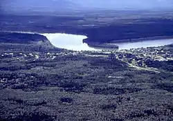 Mayo upon Stewart River, circa 2000 | |
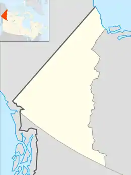 Mayo Location of Mayo  Mayo Mayo (Canada) | |
| Coordinates: 63°35′39″N 135°53′47″W | |
| Country | Canada |
| Territory | Yukon |
| Established | 1903 |
| Government | |
| • Village Mayor | Scott Bolton |
| • Governing body | Village of Mayo Council |
| • MPs | Larry Bagnell |
| • MLAs | Don Hutton |
| Area | |
| • Land | 1.06 km2 (0.41 sq mi) |
| Population (2016) | |
| • Total | 200 |
| • Density | 188.679/km2 (488.68/sq mi) |
| Time zone | UTC−07:00 (MST) |
| Forward sortation area | Y0B 1M0 |
| Area code(s) | 867 |
| Website | www.villageofmayo.ca |
The community, formerly called Mayo Landing, is serviced by Mayo Airport. The village was named after former circus acrobat turned settler and explorer Alfred Mayo.[3]
Its only school is J. V. Clark School, which is named after Dr. Clark. The school had about 70 students in 2012. The current Principal is Nicholas Vienneau.
History
Before Europeans came there were in the area two communities of the Na-cho Nyäk Dun people, who lived by hunting and trapping. The river now known as the Stewart River was known as the "Náhcho Nyäk" ("Great River"). The people lived across the Stewart River from the main focus of today's Mayo, in a district today called "Old Mayo village". The old settlement was reinstated on the initiative of a missionary, but in 1934 the river burst its banks and flattened much of the old village, destroying the church and many cultural treasures.
The first gold discoveries in the area were made in the 1880s: silver was also discovered some time later. Till the mid-twentieth century Mayo was connected with the outside world by the river and received any supplies by boat. In the 1950s the construction of the Klondike Highway and the Silver Trail provided Mayo with a road link to Stewart Crossing.
Between 1973 and 1984 negotiation took place between the government and the northern Tutchone leaders over land rights and self-government. A breakthrough came only in 1993 with a treaty[4] between the residents and the lawmakers concerning an area of 1,830 sq mi (4,700 km2) and a payment, over fifteen years, totalling C$14.5 million.
Together with the Tr'ondek Hwech’in First Nation an agreement has been made with Yukon Energy to supply electricity to Dawson City using the Mayo-Dawson Power Line.
May 2008 saw a preliminary agreement with Alexco Resource Corp. concerning silver extraction in the Keno Hill Silver area near the far end of Mayo lake where the corporation operates approximately 40 silver mines.[5]
Climate
Mayo has an extreme continental climate. The difference in temperature between the record low in February and the record high in June is 98.3 degrees C - one of the largest temperature differentials in the world for a non-desert climate. It has the warmest summers in the Yukon with a mean average summer temperature of 14.5 °C (58 °F). Mayo has a subarctic climate (Koppen: Dfc), with generally warm summers and severely cold winters lasting half the year. Spring and autumn are very short transitional seasons between summer and winter, with average temperatures rising and falling very fast during these times.
| Climate data for Mayo Airport, 1981–2010 normals, extremes 1924–present | |||||||||||||
|---|---|---|---|---|---|---|---|---|---|---|---|---|---|
| Month | Jan | Feb | Mar | Apr | May | Jun | Jul | Aug | Sep | Oct | Nov | Dec | Year |
| Record high humidex | 9.6 | 12.2 | 10.7 | 22.5 | 32.2 | 38.5 | 37.5 | 34.6 | 29.2 | 22.5 | 13.3 | 11.4 | 38.5 |
| Record high °C (°F) | 10.1 (50.2) |
12.2 (54.0) |
14.6 (58.3) |
22.8 (73.0) |
33.5 (92.3) |
36.1 (97.0) |
35.6 (96.1) |
32.6 (90.7) |
26.7 (80.1) |
22.6 (72.7) |
13.9 (57.0) |
11.8 (53.2) |
36.1 (97.0) |
| Average high °C (°F) | −18.0 (−0.4) |
−11.7 (10.9) |
−2.9 (26.8) |
7.2 (45.0) |
15.2 (59.4) |
21.4 (70.5) |
22.8 (73.0) |
19.5 (67.1) |
12.0 (53.6) |
1.2 (34.2) |
−10.9 (12.4) |
−14.7 (5.5) |
3.4 (38.1) |
| Daily mean °C (°F) | −23.1 (−9.6) |
−17.9 (−0.2) |
−9.6 (14.7) |
1.0 (33.8) |
8.8 (47.8) |
14.5 (58.1) |
16.1 (61.0) |
13.1 (55.6) |
6.4 (43.5) |
−2.7 (27.1) |
−15.3 (4.5) |
−19.9 (−3.8) |
−2.4 (27.7) |
| Average low °C (°F) | −28.2 (−18.8) |
−24.1 (−11.4) |
−16.3 (2.7) |
−5.2 (22.6) |
2.2 (36.0) |
7.5 (45.5) |
9.4 (48.9) |
6.7 (44.1) |
0.9 (33.6) |
−6.5 (20.3) |
−19.7 (−3.5) |
−25.1 (−13.2) |
−8.2 (17.2) |
| Record low °C (°F) | −58.3 (−72.9) |
−62.2 (−80.0) |
−48.9 (−56.0) |
−41.1 (−42.0) |
−21.7 (−7.1) |
−3.9 (25.0) |
−2.8 (27.0) |
−10.6 (12.9) |
−15.6 (3.9) |
−36.7 (−34.1) |
−50.6 (−59.1) |
−57.8 (−72.0) |
−62.2 (−80.0) |
| Record low wind chill | −66 | −60 | −59 | −37 | −19 | −4 | 0 | −9 | −23 | −38 | −55 | −64 | −66 |
| Average precipitation mm (inches) | 18.3 (0.72) |
13.0 (0.51) |
9.9 (0.39) |
8.8 (0.35) |
23.2 (0.91) |
39.0 (1.54) |
50.2 (1.98) |
44.6 (1.76) |
38.7 (1.52) |
27.0 (1.06) |
21.1 (0.83) |
19.8 (0.78) |
313.5 (12.34) |
| Average rainfall mm (inches) | 0.3 (0.01) |
0.0 (0.0) |
0.1 (0.00) |
2.9 (0.11) |
22.2 (0.87) |
38.9 (1.53) |
50.2 (1.98) |
44.5 (1.75) |
34.8 (1.37) |
9.4 (0.37) |
0.3 (0.01) |
0.3 (0.01) |
203.8 (8.02) |
| Average snowfall cm (inches) | 28.3 (11.1) |
20.2 (8.0) |
14.5 (5.7) |
7.8 (3.1) |
1.0 (0.4) |
0.1 (0.0) |
0.0 (0.0) |
0.3 (0.1) |
3.9 (1.5) |
23.0 (9.1) |
31.8 (12.5) |
29.8 (11.7) |
160.6 (63.2) |
| Average precipitation days (≥ 0.2 mm) | 11.1 | 8.3 | 6.4 | 5.2 | 9.9 | 12.8 | 15.1 | 13.9 | 12.8 | 12.6 | 11.9 | 11.2 | 131.2 |
| Average rainy days (≥ 0.2 mm) | 0.2 | 0.1 | 0.2 | 1.9 | 9.7 | 12.8 | 15.1 | 13.9 | 11.6 | 4.6 | 0.3 | 0.2 | 70.3 |
| Average snowy days (≥ 0.2 cm) | 12.2 | 9.1 | 6.9 | 3.9 | 0.5 | 0.0 | 0.0 | 0.1 | 1.5 | 9.3 | 13.0 | 12.3 | 68.7 |
| Average relative humidity (%) | 81.1 | 75.1 | 61.9 | 45.4 | 38.4 | 39.6 | 46.4 | 50.7 | 56.3 | 71.3 | 80.1 | 81.5 | 60.6 |
| Source: Environment Canada[6][7] | |||||||||||||
See also
References
- Census Profile, 2016 Census Mayo, Village [Census subdivision], Yukon and Canada [Country]
- http://www.eco.gov.yk.ca/stats/pdf/populationQ1_2019.pdf Population Report Q1, 2019
- "YukonWeb: The Village of Mayo". Archived from the original on 19 April 2012. Retrieved 6 October 2005.
- A summary of the treaty appears at First Nation of Na-cho Nyäk Dun Self-Government Agreement
- 'No cloud' over mining plans after Alexco, Yukon First Nation sign deal, in: CBC News, 26 May 2008
- "Mayo A" (CSV (2874 KB)). Canadian Climate Normals 1981–2010. Environment Canada. Climate ID: 2100700. Retrieved 20 February 2014.
- "Daily Data Report for March 2016". Canadian Climate Data. Environment Canada. Climate ID: 2100701. Retrieved 5 February 2017.
External links
| Regions | |
|---|---|
| Municipalities | |
| Communities | |
| Ghost towns | |
| Parks | |
| |