McCook, Nebraska
McCook is a city in and the county seat of Red Willow County, Nebraska, United States.[5] The population was 7,698 at the 2010 census.
McCook, Nebraska | |
|---|---|
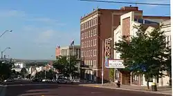 George Norris Avenue | |
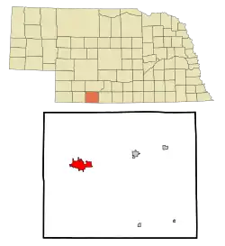 Location of McCook within Nebraska and Red Willow County | |
| Coordinates: 40°12′19″N 100°37′34″W | |
| Country | United States |
| State | Nebraska |
| County | Red Willow |
| Government | |
| • Mayor | Mike Gonzales |
| Area | |
| • Total | 5.40 sq mi (13.98 km2) |
| • Land | 5.40 sq mi (13.98 km2) |
| • Water | 0.00 sq mi (0.00 km2) |
| Elevation | 2,572 ft (784 m) |
| Population | |
| • Total | 7,698 |
| • Estimate (2019)[3] | 7,560 |
| • Density | 1,400.52/sq mi (540.74/km2) |
| Time zone | UTC−6 (Central (CST)) |
| • Summer (DST) | UTC−5 (CDT) |
| ZIP code | 69001 |
| Area code(s) | 308 |
| FIPS code | 31-29925 |
| GNIS feature ID | 0831117[4] |
| Website | cityofmccook.com |
History
McCook was platted in 1882 when the Burlington and Missouri River Railroad was extended to that point.[6][7] It was named in honor of Alexander McDowell McCook, a Brigadier General in the Union Army during the American Civil War.[8]
Geography
McCook is located at 40°12′19″N 100°37′34″W (40.205228, −100.626174).[9] According to the United States Census Bureau, the city has a total area of 5.39 square miles (13.96 km2), all land.[10]
Climate
McCook's climate is formally classified as hot-summer humid continental.[11] Due to the very hot and humid summers typical of the Midwest and the January daily mean averaging around −3 °C (27 °F)[12] it has a little bit of influence of the subtropical climates to the south, although winter nights are way too severe for subtropical plants to thrive. Winters are generally cold and dry and summers hot and humid. Precipitation is concentrated in spring and summer, accumulating to an annual normal of 22.53 in (572 mm), the majority of which occurs from May through August.[13] Snowfall is generally light, with a normal of 28.8 in (73 cm) per season, and generally occurs from November through April.[13]
Record temperatures range from −30 °F (−34 °C) on January 12, 1912, up to 115 °F (46 °C) on June 26, 2012;[13] the record cold maximum is −4 °F (−20 °C) on December 22, 1990 and December 22–23, 1989, while, conversely the record warm minimum is 88 °F (31 °C) on August 1, 1935.[13] More typically, however, there is an average of 5.4 days annually with a maximum at or above 100 °F (37.8 °C), 45 days annually with a maximum at or above 90 °F (32.2 °C), 28 days annually where the maximum stays at or below freezing, and 8.6 days annually with a minimum at or below 0 °F (−17.8 °C).[14]
| Climate data for McCook Municipal Airport, Nebraska (1981–2010 normals, extremes 1894–present) | |||||||||||||
|---|---|---|---|---|---|---|---|---|---|---|---|---|---|
| Month | Jan | Feb | Mar | Apr | May | Jun | Jul | Aug | Sep | Oct | Nov | Dec | Year |
| Record high °F (°C) | 78 (26) |
83 (28) |
93 (34) |
98 (37) |
106 (41) |
115 (46) |
114 (46) |
111 (44) |
107 (42) |
98 (37) |
89 (32) |
81 (27) |
115 (46) |
| Average high °F (°C) | 40.6 (4.8) |
44.6 (7.0) |
54.1 (12.3) |
64.5 (18.1) |
73.4 (23.0) |
84.0 (28.9) |
89.9 (32.2) |
87.6 (30.9) |
79.4 (26.3) |
66.5 (19.2) |
52.3 (11.3) |
41.0 (5.0) |
64.9 (18.3) |
| Average low °F (°C) | 13.9 (−10.1) |
17.2 (−8.2) |
24.6 (−4.1) |
34.4 (1.3) |
45.8 (7.7) |
55.9 (13.3) |
61.9 (16.6) |
59.9 (15.5) |
49.3 (9.6) |
36.2 (2.3) |
24.1 (−4.4) |
15.0 (−9.4) |
36.6 (2.6) |
| Record low °F (°C) | −30 (−34) |
−26 (−32) |
−20 (−29) |
0 (−18) |
14 (−10) |
34 (1) |
43 (6) |
39 (4) |
22 (−6) |
−1 (−18) |
−14 (−26) |
−27 (−33) |
−30 (−34) |
| Average precipitation inches (mm) | 0.51 (13) |
0.62 (16) |
1.36 (35) |
2.31 (59) |
3.14 (80) |
3.38 (86) |
3.25 (83) |
3.14 (80) |
1.44 (37) |
1.79 (45) |
0.95 (24) |
0.64 (16) |
22.53 (572) |
| Average snowfall inches (cm) | 5.5 (14) |
5.6 (14) |
5.1 (13) |
2.7 (6.9) |
0 (0) |
0 (0) |
0 (0) |
0 (0) |
0.1 (0.25) |
0.9 (2.3) |
3.5 (8.9) |
5.4 (14) |
28.8 (73) |
| Average precipitation days (≥ 0.01 in) | 2.7 | 3.8 | 5.9 | 7.4 | 10.7 | 9.1 | 8.5 | 7.7 | 5.3 | 6.1 | 4.4 | 3.5 | 75.1 |
| Average snowy days (≥ 0.1 in) | 2.4 | 2.2 | 2.0 | 1.0 | 0 | 0 | 0 | 0 | 0 | 0.4 | 1.4 | 2.3 | 11.7 |
| Source: NOAA[14][13] | |||||||||||||
Demographics
| Historical population | |||
|---|---|---|---|
| Census | Pop. | %± | |
| 1890 | 2,346 | — | |
| 1900 | 2,445 | 4.2% | |
| 1910 | 3,765 | 54.0% | |
| 1920 | 4,303 | 14.3% | |
| 1930 | 6,688 | 55.4% | |
| 1940 | 6,212 | −7.1% | |
| 1950 | 7,678 | 23.6% | |
| 1960 | 8,301 | 8.1% | |
| 1970 | 8,285 | −0.2% | |
| 1980 | 8,404 | 1.4% | |
| 1990 | 8,112 | −3.5% | |
| 2000 | 7,994 | −1.5% | |
| 2010 | 7,698 | −3.7% | |
| 2019 (est.) | 7,560 | [3] | −1.8% |
| U.S. Decennial Census[15] 2012 Estimate[16] | |||
2010 census
As of the census[2] of 2010, there were 7,698 people, 3,324 households, and 2,021 families living in the city. The population density was 1,428.2 inhabitants per square mile (551.4/km2). There were 3,717 housing units at an average density of 689.6 per square mile (266.3/km2). The racial makeup of the city was 95.8% White, 0.5% African American, 0.5% Native American, 0.4% Asian, 1.5% from other races, and 1.3% from two or more races. Hispanic or Latino of any race were 4.9% of the population.
There were 3,324 households, of which 27.4% had children under the age of 18 living with them, 47.8% were married couples living together, 9.3% had a female householder with no husband present, 3.7% had a male householder with no wife present, and 39.2% were non-families. 33.9% of all households were made up of individuals, and 16.7% had someone living alone who was 65 years of age or older. The average household size was 2.25 and the average family size was 2.89.
The median age in the city was 40.7 years. 23% of residents were under the age of 18; 9.4% were between the ages of 18 and 24; 22% were from 25 to 44; 26.2% were from 45 to 64; and 19.5% were 65 years of age or older. The gender makeup of the city was 48.3% male and 51.7% female.
2000 census
As of the census of 2000, there were 7,994 people, 3,371 households, and 2,154 families living in the city. The population density was 1,485.1 people per square mile (573.7/km2). There were 3,754 housing units at an average density of 697.4 per square mile (269.4/km2). The racial makeup of the city was 97.37% White, 0.18% African American, 0.45% Native American, 0.18% Asian, 0.91% from other races, and 0.91% from two or more races. Hispanic or Latino of any race were 2.53% of the population. The population was 7,410 in 2009.
There were 3,371 households, out of which 29.1% had children under the age of 18 living with them, 52.7% were married couples living together, 8.2% had a female householder with no husband present, and 36.1% were non-families. 31.7% of all households were made up of individuals, and 15.2% had someone living alone who was 65 years of age or older. The average household size was 2.29 and the average family size was 2.90.
In the city, the population was spread out, with 24.1% under the age of 18, 9.7% from 18 to 24, 24.2% from 25 to 44, 21.3% from 45 to 64, and 20.7% who were 65 years of age or older. The median age was 40 years. For every 100 females, there were 89.2 males. For every 100 females age 18 and over, there were 86.3 males.
As of 2000 the median income for a household in the city was $31,105, and the median income for a family was $40,455. Males had a median income of $28,065 versus $18,516 for females. The per capita income for the city was $16,691. About 7.9% of families and 9.4% of the population were below the poverty line, including 9.7% of those under age 18 and 8.4% of those age 65 or over.
Culture
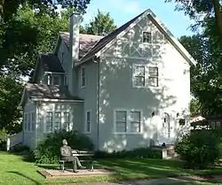
The Harvey P. Sutton House at 602 Norris Avenue was designed by influential architect Frank Lloyd Wright in 1905–1907 and built 1907–1908. The classic Prairie-style house is listed in the National Register of Historic Places; it is the only Wright house known to have been built in Nebraska.[17] The house is used as a private residence, and is not open to the public.[18]
McCook hosts the Buffalo Commons Storytelling Festival each summer.[19]
McCook Army Airfield, active from 1943 through 1945, was located nine miles northwest of McCook.
McCook hosted a professional baseball team, the McCook Braves, who played in the Nebraska State League from 1956 to 1959. In their final season in 1959, the club featured future Baseball Hall of Famer Phil Niekro and won the NSL championship; both the Braves and the league folded at season's end. Another pitcher on the team, Pat Jordan, later became a writer for the Sporting News, and wrote an autobiography dealing with his career with the Braves, A False Spring.[20]
McCook is home to the first two-year junior college in Nebraska. McCook Junior College was founded in September 1926 on the second floor of the YMCA building on Main Street. The name was eventually changed to McCook Community College and was governed over the Mid-Plains Area.[21]
Parks and recreation
McCook is home to Heritage Hills Golf Course. The 18-hole par-72 championship golf course was designed by Bradford Benz, ASGCA, and Richard M. Phelps, ASGCA, and opened in 1981. The links style course plays over 7,100 yards from the back tees. Heritage Hills was included in Golf Digest's Best 75 Golf Course's in 1984 and Golf Digest's Top 100 Toughest Public Course's in 1986. Heritage Hills underwent a major renovation for upgrades and modernization in 2013.[22]
Government
McCook has a council-manager style government. Five council members are elected at large; the five elect one of their number as mayor, and a second as vice president. As of 2015, council members are Mayor Mike Gonzales, Vice-President Janet Hepp, Jerry Calvin, Bruce McDowell, and Gene Weedin.[23]
The city government operates through eight departments and offices: Administration, Building and Zoning, Fire, Library, Police, Public Works, Senior Center, and Utilities.[24] Advisory boards and commissions, both those required by law and those created for specific purposes, are appointed by the council; as of 2015, there were fourteen such boards and commissions.[25]
Transportation
Rail
Amtrak, the national passenger rail system, provides service through McCook, operating its California Zephyr daily in both directions between Chicago and Emeryville (Oakland), California, with stops in Omaha, Lincoln, Hastings.
Air
Commuter airline Boutique Air is currently serving the McCook Regional Airport with daily nonstop round trip commercial flights to Denver, Colorado.
Media
| AM radio stations | ||||||
|---|---|---|---|---|---|---|
| Frequency | Call sign | Name | Format | Owner | Target city/market | City of license |
| 1300 AM | KBRL | The Big Talker | News/Talk | Armada Media | McCook | McCook |
| 1360 AM | KNGN | Christian | Kansas Nebraska Good News Broadcasting | McCook | McCook | |
| FM radio stations | ||||||
|---|---|---|---|---|---|---|
| Frequency | Call sign | Name | Format | Owner | Target city/market | City of license |
| 93.9 FM | KSWN-FM | The Zone | Contemporary Hits | Legacy Communications | McCook | McCook |
| 95.3 FM | KGCR | Christian | The Praise Network, Inc | McCook | - | |
| 96.1 FM | KICX-FM | Hot AC | Armada Media | McCook | McCook | |
| 102.1 FM | KZMC | True Country 102.1 | Classic Country | Legacy Communications | McCook | McCook |
| 101.1 FM | KFNF | Today's Best Country | Country | Armada Media | McCook | Oberlin |
| 103.9 | KQHK | The Hawk | Classic Rock | Armada Media | McCook | McCook |
| 105.3 FM | KIOD | Coyote 105 | Country | Legacy Communication | McCook | McCook |
Notable people
George W. Norris, who held seats in the U.S. House of Representatives and Senate from 1903 to 1943, was a resident of McCook. Norris was the driving force behind the conversion of Nebraska's legislature to a unicameral system; in the Senate, he was a leading figure behind the creation of the Tennessee Valley Authority. His house in McCook is operated as a museum by the Nebraska State Historical Society, and is listed in the National Register of Historic Places. Originally named Main, the principal north–south thoroughfare through central McCook was renamed Norris Avenue in his honor.
Three governors of Nebraska made their homes in McCook: Ralph G. Brooks, Frank Morrison, and Ben Nelson, who represented Nebraska in the U.S. Senate for two terms, from 2000 to 2012. Frank B. Morrison Jr., Montana Supreme Court justice and son of Frank Morrison, was born in McCook.
John R. McCarl, the first Comptroller General of the United States, was raised in McCook. He is also buried there.[26]
Former professional football player Jeff Kinney is a 1968 graduate of McCook High School.
TV evangelist Bob Larson was raised in McCook.
References
- "2019 U.S. Gazetteer Files". United States Census Bureau. Retrieved July 26, 2020.
- "U.S. Census website". United States Census Bureau. Retrieved June 24, 2012.
- "Population and Housing Unit Estimates". United States Census Bureau. May 24, 2020. Retrieved May 27, 2020.
- "US Board on Geographic Names". United States Geological Survey. October 25, 2007. Retrieved January 31, 2008.
- "Find a County". National Association of Counties. Archived from the original on May 31, 2011. Retrieved June 7, 2011.
- "McCook, Red Willow County". Center for Advanced Land Management Information Technologies. University of Nebraska. Retrieved August 22, 2014.
- Burr, George L. (1921). History of Hamilton and Clay Counties, Nebraska, Volume 1. S.J. Clarke Publishing Company. p. 134.
- "Exploring History in McCook, Nebraska". gotomccook.com. Retrieved August 1, 2015.
- "US Gazetteer files: 2010, 2000, and 1990". United States Census Bureau. February 12, 2011. Retrieved April 23, 2011.
- "US Gazetteer files 2010". United States Census Bureau. Archived from the original on January 12, 2012. Retrieved June 24, 2012.
- "McCook, Nebraska Climate Summary". Weatherbase. Retrieved February 12, 2015.
- "McCook, Nebraska Temperature Averages". Weatherbase. Retrieved February 12, 2015.
- "NowData - NOAA Online Weather Data". Retrieved 2020-09-08.
- "Station Name: NE MCCOOK MUNICIPAL AP". National Oceanic and Atmospheric Administration. Retrieved 2020-09-08.
- United States Census Bureau. "Census of Population and Housing". Retrieved October 16, 2013.
- "Annual Estimates of the Resident Population: April 1, 2010 to July 1, 2012". Archived from the original on November 20, 2013. Retrieved October 16, 2013.
- Murphy, D. (1978). National Register of Historic Places Inventory—Nomination Form: H. P. Sutton Residence. Nebraska State Historical Society. Retrieved September 16, 2010.
- "Landmarks & Museums". Archived 2004-02-05 at the Wayback Machine McCook Chamber of Commerce. Archived 2006-12-07 at the Library of Congress Web Archives Retrieved September 16, 2010.
- "Home". buffalocommons.org. Retrieved August 1, 2015.
- "1959 McCook Braves". Baseball-Reference.com. Retrieved August 1, 2015.
- Aten, Kenneth; Hasemeyer, William; Garey, Jerda Thompson; Koch, Ivan (2008). History of Mid-Plains Community College Volume 1. North Platte, NE: The Old 101 Press. ISBN 978-0976367666.
- Discoe, Connie Jo (2012-10-16). "Major renovation -- Heritage Hills to offer new challenges". McCook Daily Gazette. Retrieved 2019-04-07.
- "City Council". City of McCook, Nebraska. Retrieved February 25, 2015.
- "Departments". City of McCook, Nebraska. Retrieved February 25, 2015.
- "Advisory Boards & Commissions". City of McCook, Nebraska. Retrieved February 25, 2015.
- "John R. McCarl Dies of Heart Attack at 60." Washington Post. August 3, 1940; Hein, Linda. "Norris, McCarl Considered for Presidency in '36 Election." McCook Gazette. January 11, 2002.
External links
| Wikivoyage has a travel guide for McCook, Nebraska. |
Municipalities and communities of Red Willow County, Nebraska, United States | ||
|---|---|---|
| Cities | Map of Nebraska highlighting Red Willow County | |
| Villages | ||
| Unincorporated communities | ||
| ||
| Authority control |
|---|