McMillan Township, Luce County, Michigan
McMillan Township is a civil township of northern Luce County in the U.S. state of Michigan. The population was 2,692 at the 2010 census. Most of the population is centered around the county seat Newberry in the southern portion of the township. At 588.8 square miles (1,525 km2) of total land area, McMillan Township occupies 65.5% of Luce County's land area and is also the largest municipality by area in the state of Michigan. It is home to the Upper Tahquamenon Falls.
McMillan Township, Michigan | |
|---|---|
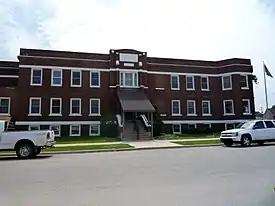 McMillan Township Hall in Newberry | |
%252C_MI_location2.png.webp) Location within Luce County (red) and the administered village of Newberry (pink) | |
 McMillan Township Location within the state of Michigan  McMillan Township McMillan Township (the United States) | |
| Coordinates: 46°32′16″N 85°30′13″W | |
| Country | United States |
| State | Michigan |
| County | Luce |
| Government | |
| • Supervisor | Arthur Schultz |
| • Clerk | Joseph Villemure |
| Area | |
| • Total | 604.35 sq mi (1,565.3 km2) |
| • Land | 588.78 sq mi (1,524.9 km2) |
| • Water | 15.57 sq mi (40.3 km2) |
| Elevation | 804 ft (245 m) |
| Population (2010) | |
| • Total | 2,692 |
| • Density | 4.57/sq mi (1.76/km2) |
| Time zone | UTC-5 (Eastern (EST)) |
| • Summer (DST) | UTC-4 (EDT) |
| ZIP code(s) | |
| Area code(s) | 906 |
| FIPS code | 26-50440[1] |
| GNIS feature ID | 1626658[2] |
Communities
- Betty B Landing (formerly Hunter's Landing) is classified as a populated place by the United States Geological Survey located at 46°24′02″N 85°16′40″W[3] on the Tahquamenon River. The landing is the northern terminus of a private railroad spur from Soo Junction, which now operates as the Toonerville Trolley Riverboat Tour offering tours on the 5.5 miles (8.9 km) 24-inch gauge railroad.[4] The branch was built by the Duluth, South Shore and Atlantic Railroad from Soo Junction to the Hunter & Love Lumber Company mill on the Tahquamenon River in 1911.[5] Built in standard gauge, the line was converted to narrow gauge to accommodate the mining engines used to pull the trolley tour's cars by Joseph Beech, Sr., founder of the riverboat tours.
- Deer Park is a former lumbering settlement in the township.
- Dollarville is an unincorporated community just west of Newberry.
- Newberry is a village on M-123. It is the county seat and the main population center in both the township and county.
- Soo Junction is an unincorporated community located east of Newberry and north of M-28.
Geography
According to the United States Census Bureau, the township has a total area of 0.98 square miles (2.54 km2), of which 0.98 square miles (2.54 km2) is land and 0.98 square miles (2.54 km2) is water.[6]
Demographics
2010
As of the census[1] of 2010, there were 2,692 people, 1,193 households, and 701 families residing in the township. The racial makeup of the township was 82.2% White, 0.3% African American, 6.2% Native American, 0.2% Asian, 0.03% Pacific Islander, 0.79% from other races, and 4.1% from two or more races. Hispanic or Latino of any race were 1.6% of the population.
There were 2,692 households, out of which 24.1% had children under the age of 18 living with them, 42.7% were married couples living together, 11.5% had a female householder with no husband present, and 41.2% were non-families. 55.1% of all households were made up of individuals, and 30.8% had someone living alone who was 65 years of age or older. The average household size was 2.20 and the average family size was 2.84.
2000
As of the census[1] of 2000, there were 3,947 people, 1,240 households, and 813 families residing in the township. The population density was 6.7 per square mile (2.6/km2). There were 1,979 housing units at an average density of 3.3 per square mile (1.3/km2). The racial makeup of the township was 76.39% White, 13.28% African American, 5.60% Native American, 0.46% Asian, 0.03% Pacific Islander, 0.79% from other races, and 3.47% from two or more races. Hispanic or Latino of any race were 2.86% of the population.
There were 1,240 households, out of which 30.7% had children under the age of 18 living with them, 50.9% were married couples living together, 10.6% had a female householder with no husband present, and 34.4% were non-families. 30.8% of all households were made up of individuals, and 15.3% had someone living alone who was 65 years of age or older. The average household size was 2.35 and the average family size was 2.89.
In the township the population was spread out, with 19.7% under the age of 18, 10.8% from 18 to 24, 34.9% from 25 to 44, 20.1% from 45 to 64, and 14.5% who were 65 years of age or older. The median age was 36 years. For every 100 females, there were 146.2 males. For every 100 females age 18 and over, there were 165.0 males.
The median income for a household in the township was $30,514, and the median income for a family was $35,101. Males had a median income of $30,118 versus $20,608 for females. The per capita income for the township was $17,007. About 14.6% of families and 16.9% of the population were below the poverty line, including 19.8% of those under age 18 and 9.7% of those age 65 or over.
References
- "U.S. Census website". United States Census Bureau. Retrieved 2008-01-31.
- U.S. Geological Survey Geographic Names Information System: McMillan Township, Luce County, Michigan
- U.S. Geological Survey Geographic Names Information System: Betty B Landing
- Taquamenon Falls Wilderness Excursion
- Hunter Mill Branch Switch, MI, Michigan Internet Railroad History
- "Michigan: 2010 Population and Housing Unit Counts 2010 Census of Population and Housing" (PDF). 2010 United States Census. United States Census Bureau. September 2012. p. 32 Michigan. Retrieved April 12, 2020.
Municipalities and communities of Luce County, Michigan, United States | ||
|---|---|---|
| Village | 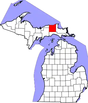 Map of Michigan highlighting Luce County.svg | |
| Civil townships | ||
| Unincorporated communities | ||
| Indian reservation | ||
| Footnotes | ‡This populated place also has portions in an adjacent county or counties | |
| ||