Meadowbank, New Zealand
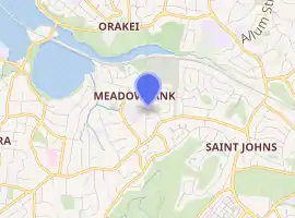
Meadowbank is a suburb of Auckland city, situated in the North Island of New Zealand.
Meadowbank | |
|---|---|
Suburb | |
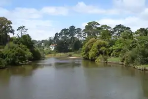
 Orakei Creek in Meadowbank, as seen from the Waiatarua Road overbridge | |

| |
| Country | New Zealand |
| Local authority | Auckland Council |
| Electoral ward | Ōrākei Ward |
| Population (2018) | |
| • Total | 5,328 |
| Postcode(s) | 1072 |
| Train station(s) | Meadowbank Railway Station |
| Parnell (3.9 km) | Orakei (1.6 km) | Mission Bay (2.0 km) |
| Remuera (2.2 km) |
|
Glen Innes (3.6 km) |
| Greenlane (3.6 km) | Ellerslie (3.2 km) | St Johns (1.9 km) |
Meadowbank is governed under the local governance of the Auckland Council. It has one shopping centre: Meadowbank Shopping Centre, on the corner of Gerard Way and St John's Road
Purewa Cemetery, one of central Auckland's largest cemeteries, is situated in Meadowbank and can be accessed from St John's Road. St John's College and Trinity Theological College are also located on St John's Road.
Local primary schools include Meadowbank School (public) and Mt Carmel School, Meadowbank (state-integrated Catholic). Local secondary schools comprise Selwyn College and Baradene College of the Sacred Heart.
Meadowbank is also home to the Waiatarua Reserve, the biggest urban wetland restoration project in New Zealand. The 20-hectare reserve was once a freshwater lake, but the landscape was altered by the Maungarei / Mount Wellington volcanic eruptions approximately 9000 years ago.[1]
Demographics
| Year | Pop. | ±% p.a. |
|---|---|---|
| 2006 | 4,695 | — |
| 2013 | 5,049 | +1.04% |
| 2018 | 5,328 | +1.08% |
| Source: [2] | ||
Meadowbank, comprising the statistical areas of Meadowbank West and Meadowbank East, had a population of 5,328 at the 2018 New Zealand census, an increase of 279 people (5.5%) since the 2013 census, and an increase of 633 people (13.5%) since the 2006 census. There were 1,947 households. There were 2,499 males and 2,829 females, giving a gender ratio of 0.88 males per female. 1,188 people were (22.3%) aged under 15 years, 840 (15.8%) aged 15 to 29, 2,619 (49.2%) aged 30 to 64, and 684 (12.8%) aged 65 or older.
Ethnicities included European/Pākehā (76.5%), Māori (6.2%), Pacific peoples (4.8%), Asian (16.8%), and others (4.1%). The percentage totals add to more than 100% as people could identify with multiple ethnicities.
The proportion of people born overseas was 33.8%, compared with the national level of 27.1%.
44.3% of the population reported to have no religion, while 43.2% were Christian and 7.4% believed in other religions. Some people objected to disclosing their religion.
Of residents who were at least 15 years old, 1,914 (46.2%) had a bachelor or higher degree, and 291 (7.0%) people had no formal qualifications. Of the same sub-group, 2,325 (56.2%) were employed full-time, 600 (14.5%) were employed part-time, and 138 (3.3%) were unemployed.[2]
Education
Mount Carmel School is a coeducational state-integrated Catholic primary school (years 1-6) with a roll of 244 as of March 2020.[3][4]
References
- "Parks search: Waiatarua Reserve". Auckland Council. Retrieved 11 April 2012.
- "Statistical area 1 dataset for 2018 Census". Statistics New Zealand. March 2020. Meadowbank West (141900) and Meadowbank East (143200). 2018 Census place summary: Meadowbank West 2018 Census place summary: Meadowbank East
- "New Zealand Schools Directory". New Zealand Ministry of Education. Retrieved 26 April 2020.
- Education Counts: Mount Carmel School
External links
- Photographs of Meadowbank held in Auckland Libraries' heritage collections.