Melbourne Sandbelt
The Melbourne Sandbelt is a region to the southeast of Melbourne Australia known for its sandy soil. Several significant golf courses are located in the region.
| Melbourne Sandbelt Victoria | |
|---|---|
 Melbourne Sandbelt | |
| Coordinates | 37°58′26″S 145°7′6″E |
Location
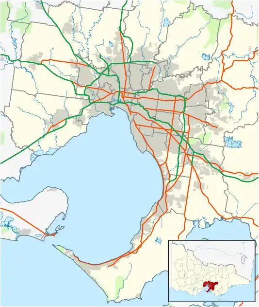
The Melbourne Sandbelt is a rough triangle extending from Brighton south along the coast of Port Phillip Bay to Frankston and to the east as far as Heatherton, Clayton and Oakleigh.
Geology
Much of Melbourne’s eastern suburbs are covered by heavy clay subsoil. Around 20 million years ago, lower lying areas were flooded, which deposited sandstone material, now known as the Brighton Group.[1] [2] [3] [4] The Sandbelt suburbs are built on remnant sand dunes from this time.[5] The sand can reach a depth of 80 metres in some places.[6] Further east and north, the clay remains, and this region is sometimes referred to as the Clay Belt by contrast to the Sandbelt.
Flora of the Sandbelt
The surface soils across the Sandbelt today are the result of the geology, topography, marine currents, climate and vegetation. The present day coastal dune systems were formed in the last 6000 years by wave action depositing sand and silts from the bay onto its beaches. The most prominent dune systems are between Mordialloc and Frankston. This formed a coastal barrrier, behind which occurs the Carrum-Carrum Swamp in a section of the Port-Phillip sunkland.
As Melbourne's extensive suburbs grew, much of the Sandbelt's remnant vegetation was destroyed. Currently, there are few locations where the vegetation has been preserved. However, revegetation efforts by local concils are ongoing, and seek to return the land back to the remnant vegetation (prior to European settlement). To help achieve this, various vegetation communities have been identified.[7]
The following table presents the different vegetation communities of the Sandbelt, along with a list of associated species.
Vegetation communities of the Sandbelt
| Primary Dune Vegetation | Coastal Scrub | Wetlands | Heathy Woodlands | |
|---|---|---|---|---|
| Vegetation community and soil proprties | 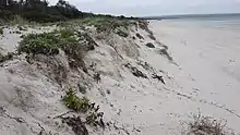 Example location: Carrum Beach Soil: Wind blown sands on beach dunes, normally with high pH. | 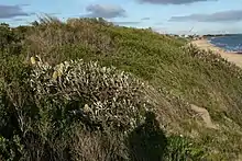 Example location: Mentone Beach Soil: Coastal sand dunes and sandstone bluff, inland of primary dune vegetation. | 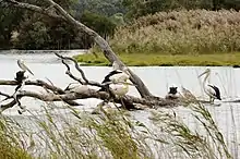 Example location: Braeside Park, Braeside Soil: Variable, usually heavy, clayey soils, relatively high in nutrients with permanently and seasonally inundated areas. | 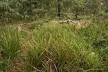 Example location: Bradshaw Bushland Reserve, Mordialloc. Soil: Deep free-draining, nutrient poor sands on crests and slopes of undulating sand hills and ridges, usually slightly acidic. |
| Ground layer |
|
|
|
|
| Climbers | ||||
| Shrubs |
|
| ||
| Trees | None |
Sand mining
Sand mining has been conducted in the Sandbelt region since the 1880s.[8] Several former sand mining sites have been used for landfill waste disposal once mining ceased.[9]
Golf courses
Sandy soil is particularly suitable for golf courses. It is easy to place bunkers wherever a course designer chooses, without the need to carry in sand from another location, and it is easy to ensure appropriate drainage. A feature of several Melbourne Sandbelt courses is that bunkers are cut right on the edge of a green, which is not possible in other courses with different soil types.
There are several major championship courses in the Melbourne Sandbelt which are regularly listed among the world's best. Notable courses include Royal Melbourne Golf Club, Victoria Golf Club, Kingston Heath Golf Club, Huntingdale Golf Club, and Metropolitan Golf Club. Royal Melbourne and Kingston Heath both feature in the Golf Digest top 20 courses in the world.[10]
List of Sandbelt courses
Major championship courses
- Commonwealth Golf Club, Oakleigh South
- Huntingdale Golf Club, Oakleigh South
- Kingston Heath, Heatherton
- Metropolitan Golf Club, Oakleigh South
- Royal Melbourne Golf Club, Black Rock
- Victoria Golf Club, Cheltenham
- Yarra Yarra Golf Club, Bentleigh East
Private courses
- Capital Golf Club, Heatherton
- Cheltenham Golf Club, Cheltenham
- Keysborough Golf Club, Keysborough
- Long Island Country Club, Frankston North
- Patterson River Golf Club, Bonbeach
- Peninsula Kingswood Country Golf Club, Frankston, and Dingley Village
- Rossdale Golf Club, Aspendale
- Sandhurst Club, Skye
- Southern Golf Club, Keysborough
- Spring Valley Golf Club, Clayton South
- Woodlands Golf Club, Mordialloc
Public courses
- Amstel Park, Cranbourne
- Brighton Golf Course Brighton, Victoria
- Centenary Park, Frankston
- Chelsea Public Golf Course, Edithvale
- Sandringham Golf Course, Cheltenham
- Spring Park Golf Course, Dingley Village
References
- "Australian Stratigraphic Units Database - Stratigraphic Unit Details (Brighton Group)". asud.ga.gov.au.
- "Melbourne - Geology". emelbourne.net.au.
- http://www.beaumarisconservation.net/sandenv8.pdf, figure 1|
- "Australian Stratigraphic Units Database - Stratigraphic Unit Details (Red Bluff Sandstone)". asud.ga.gov.au.
- "Geology of Melbourne". greenlivingpedia.org.
- Bouazza, A., Kodikara, J., and Parker, R., "On the Use of Sand Washing Slimes for Waste Containment" Geotechnics of High Water Content Materials ASTM STP 1374, T.B. Edil and P.J. Fox, Eds., American Society For Testing and Materials, West Conshohocken, PA, USA, 2000 https://books.google.com/books?id=iQhDe5OdyXkC&pg=PA293&lpg=PA293&dq=clayton+sand+mining+landfill&source=bl&ots=M-h4Rkqlom&sig=vHr43_r-aTciZMEkhx_paZjLK0w&hl=en&sa=X&ei=873XUuGUE86fkgWY44GoAg&ved=0CEUQ6AEwBQ#v=onepage&q=clayton%20sand%20mining%20landfill&f=false
- Scott, Rob; Blake, Neil; Campbell, Jeannie; Evans, Doug; Williams, Nicholas (2002). Indigenous Plants of the Sandbelt: A Gardening Guide dor South-eastern Melbourne. St Kilda: Earthcare. p. 1. ISBN 0 9581009 0 X.
- http://localhistory.kingston.vic.gov.au/htm/article/294.htm
- "Geotechnics of Land Disposal of Waste" in Geoenvironmental Engineering Contaminated Ground: Fate of Pollutants and Remediation, ed. R. Yong and H.R. Thomas, 1997 p.301 https://books.google.com/books?id=WaU0igJ5a0wC&lpg=PA301&ots=pUgeEB_NXb&dq=clayton%20sand%20mining%20landfill&pg=PA301#v=onepage&q=clayton%20sand%20mining%20landfill&f=false
- http://www.golfdigest.com/golf-courses/2014-02/top-20-world-photos
External links
- Melbourne Sandbelt Golf Map
- The Melbourne Sandbelt - Classic Golf - an association of major courses
- Interview with Paul Daley and David Scaletti, authors of The Sandbelt – Melbourne’s Golfing Heaven ISBN 095802250X.
- Musician Lloyd Cole's account of playing the Sandbelt courses, which won the Australian Golf Writer's Best Feature of the Year Award in 2009.
