Melville, North Dakota
Melville is an unincorporated community in Foster County, North Dakota, United States. Melville is located along U.S. routes 52 and 281 and the Red River Valley and Western Railroad, 9 miles (14 km) south-southeast of Carrington.[2] Melville was originally named Newport after Northern Pacific Railway treasurer R. M. Newport; its name was changed to Melville for landowner Melville D. Carrington.[1]
Melville, North Dakota | |
|---|---|
 Melville  Melville | |
| Coordinates: 47°20′05″N 99°02′08″W | |
| Country | United States |
| State | North Dakota |
| County | Foster |
| Elevation | 1,604 ft (489 m) |
| Time zone | UTC-6 (Central (CST)) |
| • Summer (DST) | UTC-5 (CDT) |
| Area code(s) | 701 |
| GNIS feature ID | 1030192[1] |
References
- "Melville". Geographic Names Information System. United States Geological Survey.
- Foster County, North Dakota General Highway Map (PDF) (Map). North Dakota Department of Transportation. 2004. Retrieved July 18, 2012.
Municipalities and communities of Foster County, North Dakota, United States | ||
|---|---|---|
| Cities | 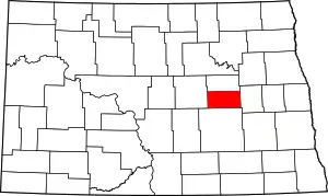 Map of North Dakota highlighting Foster County | |
| Townships | ||
| Unincorporated communities | ||
| ||
This article is issued from Wikipedia. The text is licensed under Creative Commons - Attribution - Sharealike. Additional terms may apply for the media files.