Merna, Nebraska
Merna is a village in Custer County, Nebraska, United States. The population was 363 at the 2010 census.
Merna, Nebraska | |
|---|---|
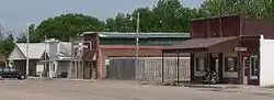 Downtown Merna: north side of Center Avenue | |
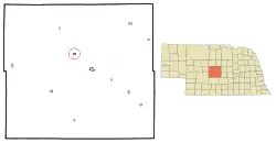 Location of Merna, Nebraska | |
 Merna Location within Nebraska  Merna Location within the United States | |
| Coordinates: 41°29′5″N 99°45′44″W | |
| Country | United States |
| State | Nebraska |
| County | Custer |
| Township | Kilfoil |
| Area | |
| • Total | 0.54 sq mi (1.39 km2) |
| • Land | 0.54 sq mi (1.39 km2) |
| • Water | 0.00 sq mi (0.00 km2) |
| Elevation | 2,664 ft (812 m) |
| Population | |
| • Total | 363 |
| • Estimate (2019)[3] | 363 |
| • Density | 677.24/sq mi (261.68/km2) |
| Time zone | UTC-6 (Central (CST)) |
| • Summer (DST) | UTC-5 (CDT) |
| ZIP code | 68856 |
| Area code(s) | 308 |
| FIPS code | 31-31780[4] |
| GNIS feature ID | 0831232[5] |
History
Merna was founded in the 1880s about the time the railroad was extended to that point.[6] It was named Merna in honor of the young daughter of the first postmaster.[7]
Geography
Merna is located at 41°29′5″N 99°45′44″W (41.484618, -99.762293).[8]
According to the United States Census Bureau, the village has a total area of 0.54 square miles (1.40 km2), all land.[9]
Recently, Merna was at the center of a geological controversy regarding a depression in the land several miles west of town in the loess hills. Originally called the Bartak Depression after the owners of the land, it was redubbed the Merna Crater by University of Kansas geology professor Wakefield Dort, Jr. Further research showed the crater to be more likely formed by wind and water erosion, but memories of the flurry of importance in the small town remain.[10][11]
Demographics
| Historical population | |||
|---|---|---|---|
| Census | Pop. | %± | |
| 1900 | 141 | — | |
| 1910 | 459 | 225.5% | |
| 1920 | 553 | 20.5% | |
| 1930 | 439 | −20.6% | |
| 1940 | 414 | −5.7% | |
| 1950 | 385 | −7.0% | |
| 1960 | 349 | −9.4% | |
| 1970 | 322 | −7.7% | |
| 1980 | 389 | 20.8% | |
| 1990 | 377 | −3.1% | |
| 2000 | 391 | 3.7% | |
| 2010 | 363 | −7.2% | |
| 2019 (est.) | 363 | [3] | 0.0% |
| U.S. Decennial Census[12] | |||
2010 census
As of the census[2] of 2010, there were 363 people, 151 households, and 110 families living in the village. The population density was 672.2 inhabitants per square mile (259.5/km2). There were 174 housing units at an average density of 322.2 per square mile (124.4/km2). The racial makeup of the village was 98.6% White, 0.3% from other races, and 1.1% from two or more races. Hispanic or Latino of any race were 1.4% of the population.
There were 151 households, of which 32.5% had children under the age of 18 living with them, 58.9% were married couples living together, 9.3% had a female householder with no husband present, 4.6% had a male householder with no wife present, and 27.2% were non-families. 26.5% of all households were made up of individuals, and 11.3% had someone living alone who was 65 years of age or older. The average household size was 2.40 and the average family size was 2.87.
The median age in the village was 40.2 years. 27.5% of residents were under the age of 18; 6.4% were between the ages of 18 and 24; 22.6% were from 25 to 44; 30.1% were from 45 to 64; and 13.5% were 65 years of age or older. The gender makeup of the village was 48.5% male and 51.5% female.
2000 census
As of the census[4] of 2000, there were 391 people, 157 households, and 116 families living in the village. The population density was 734.5 people per square mile (284.8/km2). There were 176 housing units at an average density of 330.6 per square mile (128.2/km2). The racial makeup of the village was 98.47% White, 0.51% African American, 0.51% Native American, 0.26% from other races, and 0.26% from two or more races. Hispanic or Latino of any race were 1.28% of the population.
There were 157 households, out of which 34.4% had children under the age of 18 living with them, 64.3% were married couples living together, 7.0% had a female householder with no husband present, and 26.1% were non-families. 24.2% of all households were made up of individuals, and 10.8% had someone living alone who was 65 years of age or older. The average household size was 2.49 and the average family size was 2.96.
In the village, the population was spread out, with 29.2% under the age of 18, 4.9% from 18 to 24, 25.8% from 25 to 44, 23.8% from 45 to 64, and 16.4% who were 65 years of age or older. The median age was 38 years. For every 100 females, there were 95.5 males. For every 100 females age 18 and over, there were 92.4 males.
As of 2000 the median income for a household in the village was $31,250, and the median income for a family was $36,406. Males had a median income of $27,083 versus $18,958 for females. The per capita income for the village was $15,474. About 10.1% of families and 13.5% of the population were below the poverty line, including 22.2% of those under age 18 and 4.2% of those age 65 or over.
References
- "2019 U.S. Gazetteer Files". United States Census Bureau. Retrieved July 26, 2020.
- "U.S. Census website". United States Census Bureau. Retrieved 2012-06-24.
- "Population and Housing Unit Estimates". United States Census Bureau. May 24, 2020. Retrieved May 27, 2020.
- "U.S. Census website". United States Census Bureau. Retrieved 2008-01-31.
- "US Board on Geographic Names". United States Geological Survey. 2007-10-25. Retrieved 2008-01-31.
- "Merna, Custer County". Center for Advanced Land Management Information Technologies. University of Nebraska. Retrieved 4 August 2014.
- Fitzpatrick, Lillian L. (1960). Nebraska Place-Names. University of Nebraska Press. p. 47. ISBN 0803250606. A 1925 edition is available for download at University of Nebraska—Lincoln Digital Commons.
- "US Gazetteer files: 2010, 2000, and 1990". United States Census Bureau. 2011-02-12. Retrieved 2011-04-23.
- "US Gazetteer files 2010". United States Census Bureau. Archived from the original on 2012-01-25. Retrieved 2012-06-24.
- http://www.cbsnews.com/stories/2002/07/22/tech/main515846.shtml
- http://www.unl.edu/scarlet/v11n29/v11n29features.html
- "Census of Population and Housing". Census.gov. Retrieved June 4, 2015.
Municipalities and communities of Custer County, Nebraska, United States | ||
|---|---|---|
| Cities | Map of Nebraska highlighting Custer County | |
| Villages | ||
| Townships | ||
| CDP | ||
| Unincorporated communities | ||
| Ghost towns | ||
| ||