Mhasla
Mhasla is a census town in Raigad district in the Indian state of Maharashtra.
Mhasla | |
|---|---|
village | |
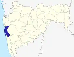
 Mhasla Location in Maharashtra, India | |
| Coordinates: 18.13°N 73.12°E | |
| Country | |
| State | Maharashtra |
| District | Raigad |
| Elevation | 93 m (305 ft) |
| Population (2001) | |
| • Total | 8,762 |
| Languages | |
| • Official | Marathi |
| Time zone | UTC+5:30 (IST) |
| PIN | 402105 |
| Telephone code | 2149232240 |
| Vehicle registration | MH-06 |
| Nearest city | Mangaon |
| Lok Sabha constituency | Raigad |
| Assemblyconstituency | Shrivardhan |
| Avg. summer temperature | 36 °C (97 °F) |
| Avg. winter temperature | 16 °C (61 °F) |
Geography
Mhasla is located at 18.13°N 73.12°E.[1] It has an average elevation of 93 metres (305 feet).
Demographics
As of 2001 India census,[2] Mhasla had a population of 8,762. It is one hour away from the Mumbai-Goa Highway and 3 hours (190 km) from Mumbai.
References
- Falling Rain Genomics, Inc - Mhasla
- "Census of India 2001: Data from the 2001 Census, including cities, villages and towns (Provisional)". Census Commission of India. Archived from the original on 16 June 2004. Retrieved 1 November 2008.
This article is issued from Wikipedia. The text is licensed under Creative Commons - Attribution - Sharealike. Additional terms may apply for the media files.