Międzychód County
Międzychód County (Polish: powiat międzychodzki) is a unit of territorial administration and local government (powiat) in Greater Poland Voivodeship, west-central Poland. It came into being on January 1, 1999, as a result of the Polish local government reforms passed in 1998. Its administrative seat and largest town is Międzychód, which lies 74 kilometres (46 mi) west of the regional capital Poznań. The only other town in the county is Sieraków, lying 16 km (10 mi) east of Międzychód.
Międzychód County
Powiat międzychodzki | |
|---|---|
Flag  Coat of arms | |
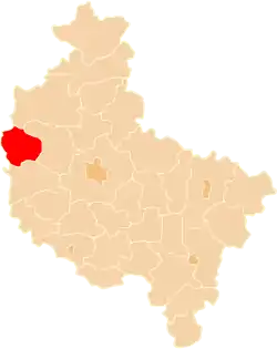 Location within the voivodeship | |
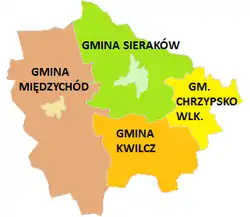 Division into gminas | |
| Coordinates (Międzychód): 52°36′N 15°53′E | |
| Country | |
| Voivodeship | Greater Poland |
| Seat | Międzychód |
| Gminas | |
| Area | |
| • Total | 736.66 km2 (284.43 sq mi) |
| Population (2006) | |
| • Total | 36,329 |
| • Density | 49/km2 (130/sq mi) |
| • Urban | 16,914 |
| • Rural | 19,415 |
| Car plates | PMI |
| Website | http://www.powiat-miedzychodzki.pl |
The county covers an area of 736.66 square kilometres (284.4 sq mi). As of 2006 its total population is 36,329, out of which the population of Międzychód is 10,920, that of Sieraków is 5,994, and the rural population is 19,415.
Neighbouring counties
Międzychód County is bordered by Czarnków-Trzcianka County to the north-east, Szamotuły County to the east, Nowy Tomyśl County to the south, Międzyrzecz County to the south-west and Strzelce-Drezdenko County to the north-west.
Administrative division
The county is subdivided into four gminas (two urban-rural and two rural). These are listed in the following table, in descending order of population.
| Gmina | Type | Area (km²) |
Population (2006) |
Seat |
| Gmina Międzychód | urban-rural | 307.2 | 18,290 | Międzychód |
| Gmina Sieraków | urban-rural | 203.3 | 8,649 | Sieraków |
| Gmina Kwilcz | rural | 141.8 | 6,097 | Kwilcz |
| Gmina Chrzypsko Wielkie | rural | 84.3 | 3,293 | Chrzypsko Wielkie |
References
| Seat | | |
|---|---|---|
| Urban-rural gminas | ||
| Rural gminas | ||
| City counties |  | |
|---|---|---|
| Land counties | ||
