Mi'irabawi Zone
Mi'irabawi (or "Western") is the westernmost Zone of the Tigray Region in Ethiopia. It is subdivided into three woredas (districts); from north to south they are Kafta Humera, Wolqayt and Tsegede. Major towns and cities include Humera. Mi'irabawi is bordered on the east by the Semien Mi'irabawi (North Western) Zone, the south by the Amhara Region, the west by Sudan and on the north by Eritrea. In November 2020, the administration of parts of Western Tigray was taken over by officials from Amhara Region, on the occasion of the war against Tigray.[2]
Western Tigray
Mi'irabawi | |
|---|---|
 Flag | |
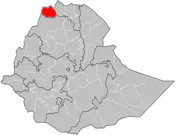 Western Tigray location in Ethiopia | |
| Country | Ethiopia |
| Region | Tigray Region |
| Largest city | Humera |
| Area | |
| • Total | 12,323.35 km2 (4,758.07 sq mi) |
| Population (2012 est.) | |
| • Total | 407,560 |
| • Density | 33/km2 (86/sq mi) |
Demographics
Based on the 2007 Census conducted by the Central Statistical Agency of Ethiopia (CSA), this Zone has a total population of 356,598, of whom 182,571 are men and 174,027 women; 71,823 or 20.14% are urban inhabitants. Two largest ethnic groups reported in Semien Mi'irabawi were the Tigray (92.28%), and Amhara (6.48%); all other ethnic groups made up 1.24% of the population. Tigrinya is spoken as a first language by 86.73, and Amharic by 12.18%; the remaining 1.09% spoke all other primary languages reported. 96.25% of the population said they were Orthodox Christians, and 3.68% were Muslim.[3]
At the time of the 1994 national census, Mi'irabawi included the six woredas that were split off in 2005 to form the new Semien Mi'irabawi Zone. That census reported a total population of 733,962, of whom 371,198 were males and 362,764 females; 84,560 or 11.5% of its population were urban dwellers. The inhabitants of the Zone were predominantly Tigrayan, at 91.5% of the population, while 4.3% were Amhara, 3.5% foreign residents from Eritrea, and 0.2% Kunama; all other ethnic groups accounted for 0.5% of the population. Tigrinya was spoken as a first language by 94.45% of the inhabitants, and Amharic by 4.85%; the remaining 0.7% spoke all other primary languages reported. 96.28% of the population said they were Orthodox Christians, and 3.51% were Muslim. Concerning education in the Zone, 9.01% of the population were considered literate; 11.34% of children aged 7-12 were in primary school, while 0.65% of the children aged 13-14 were in junior secondary school, and 0.51% of children aged 15-18 were in senior secondary school. Concerning sanitary conditions, about 63% of the urban houses and 18% of all houses had access to safe drinking water at the time of the census; about 19% of the urban and 5% of the total had toilet facilities.[4]
According to a 24 May 2004 World Bank memorandum, 6% of the inhabitants of Mi'irabawi Zone have access to electricity, and this zone has a road density of 23.3 kilometers per 1000 square kilometers. Rural households have an average of 1 hectare of land (compared to the national average of 1.01 and a regional average of 0.51)[5] and an average 1.3 head of livestock. 19.9% of the population is in non-farm related jobs, compared to the national average of 25% and a regional average of 28%. Of all eligible children, 55% are enrolled in primary school, and 16% in secondary schools. 100% of the zone is exposed to malaria, and 0% to Tsetse fly. The memorandum gave this zone a drought risk rating of 533.[6]
History
During the 2020-2021 Tigray War, attacks were carried out on Western Tigray by the joint Ethiopian and Eritrean armies, as well as Amhara Region militia. An EEPA report stated that satellite imagery allowed detecting fires in Shimelba refugee camp. The origin was unknown. [7] On 18 December 2020, EEPa continued reporting looting, including 500 dairy cows and hundreds of calves stolen by Amhara forces. [7] On 20 December 2020, in Western Tigray, VRT journalist Stijn Vercruysse reported footage of deserted homesteads. He stated that the estimation that 1 million Tigrayan people have been displaced in Tigray might be an understatement. Vercruysse confirmed the presence of Eritrean soldiers and confirmed the abduction of Eritrean refugees in Tigray by Eritrean forces back to Eritrea. He found the Shimelba refugee camp almost deserted. [8] On 21 December 2020, EEPA reported that the crop harvest in Tigray is worst hit (1) in Southern Tigray because of heavy damage by desert locust swarms; (2) in Western Tigray where Amhara and Eritrean soldiers are all over the place, and people fear harvesting crops; (3) in places along the roads, where soldiers may burn harvested crops that had been heaped earlier on.[9]
Notes
- Geohive: Ethiopia Archived 2012-08-05 at the Wayback Machine
- "Inside Humera, a town scarred by Ethiopia's war". Reuters. 2020-11-23. Retrieved 2020-11-24.
- Census 2007 Tables: Tigray Region Archived 2010-11-14 at the Wayback Machine, Tables 2.1, 3.1, 3.2, 3.4.
- The 1994 Population and Housing Census of Ethiopia: Tigray Region Archived 2008-11-19 at the Wayback Machine, vol. 1, part 1: Tables 2.1, 2.11, 2.19, 3.5, 3.7, 6.3, 6.11, 6.13
- Comparative national and regional figures from the World Bank publication, Klaus Deininger et al. "Tenure Security and Land Related Investment", WP-2991 (accessed 23 March 2006).
- World Bank, Four Ethiopias: A Regional Characterization (accessed 23 March 2006).
- Situation Report EEPA HORN No. 30 - 19 December Europe External Programme with Africa
- VRT NWS als eerste in noorden van Tigray in Ethiopië: "Geweld houdt aan, er zijn zeker veel burgers gedood" VRT Nieuws, 20 December 2020
- Situation Report EEPA HORN No. 33 - 22 December Europe External Programme with Africa
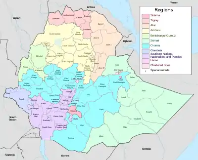
Zones of the Tigray Region | ||
|---|---|---|
| ||