Midōsuji
Midōsuji (御堂筋, Midō-suji) Boulevard is the primary main street in central Osaka, Japan. It runs north-south, passing Umeda, Nakanoshima, Shinsaibashi, Dōtonbori, Ame-mura, and Namba districts. Underneath the street is the Midōsuji Line subway. Especially in autumn when leaves of the ginkgo roadside trees turn yellow, a beautiful landscape can be seen.
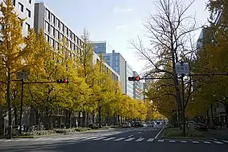 Autumn colors along Midōsuji | |
| Former name(s) | Yodoyabashisuji (淀屋橋筋) |
|---|---|
| Length | 4.027 km (2.502 mi) |
| Width | 43.6 metres (143 ft) |
| Location | Osaka (Umeda, Nakanoshima, Shinsaibashi, Dōtonbori, Ame-mura, and Namba) |
| South end | |
| Major junctions | |
| North end | |

Route description
Midōsuji becomes the Shinmido-suji in Kita-ku, Osaka, running concurrently with Japan National Route 423. After travelling about 16 kilometres (9.9 mi) to the north it becomes the Minō Toll Road.[1] To the south, Midōsuji becomes the Kishu Highway[2] to the south.
History
In Edo period, Midosuji was just a narrow street called "Yodoyabashisuji (淀屋橋筋)". Midōsuji was built in the Taishō period, widening an existing north-south street and extending it to run all the way to Umeda in the north and Namba in the south.
Today Midōsuji is an ultra high-class shopping street, housing clothing stores by such brands as Louis Vuitton, Chanel, major hotels, and even an Apple flagship.[3]
The area has been referred to in songs by popular artists such as Hitomi Yaida on her 2006 album It's a New Day.[4]
Features
| Point | Coordinates (links to map & photo sources) |
Notes |
|---|---|---|
| Ōsaka Station | 34.7018°N 135.4986°E | Umeda |
| Keihan National Highway | 34.6983°N 135.5005°E | The terminus of Japan National Route 1 |
| Shin-Midōsuji | 34.6963°N 135.5013°E | |
| Nakanoshima | 34.6938°N 135.5011°E | Nakanoshima |
| Chūō Ōdōri | 34.6818°N 135.5006°E | |
| Nagahori-dōri | 34.6751°N 135.5004°E | Shinsaibashi |
| Dōtonbori Canal | 34.669°N 135.5003°E | Dōtonbori |
| Sennichimae-dōri | 34.6671°N 135.5003°E | |
| Namba | 34.6647°N 135.4999°E | Namba |
References
- http://www.osaka-road.or.jp/mino.html
- http://www.city.osaka.lg.jp/contents/wdu020/sumiyoshi/english/attract/attrac05.html
- "Midosuji". Retrieved 4 August 2019.
- "Midousuji PLANET (御堂筋PLANET) Lyrics". Retrieved 4 August 2019.
| Wikimedia Commons has media related to Midōsuji. |
