Milbank, South Dakota
Milbank is a city in Grant County, South Dakota, United States, located along the South Fork of the Whetstone River. The population was 3,353 at the 2010 census. It is the county seat of Grant County.[6] In 1925 The American Legion Department of South Dakota established a new program for high school aged youth that grew into a national program. Milbank is the birthplace of American Legion Baseball, which is played in all fifty states by more than five thousand teams.
Milbank | |
|---|---|
| Milbank, South Dakota | |
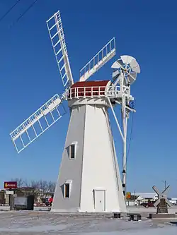 Holland Grist Windmill, Milbank | |
| Motto(s): "You'll Like Milbank" | |
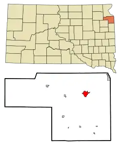 Location in Grant County and the state of South Dakota | |
| Coordinates: 45°13′7″N 96°38′1″W | |
| Country | United States |
| State | South Dakota |
| County | Grant |
| Incorporated | 1881[1] |
| Government | |
| • Mayor | Pat Raffety |
| Area | |
| • Total | 2.86 sq mi (7.40 km2) |
| • Land | 2.77 sq mi (7.19 km2) |
| • Water | 0.08 sq mi (0.22 km2) |
| Elevation | 1,152 ft (351 m) |
| Population | |
| • Total | 3,353 |
| • Estimate (2019)[4] | 3,103 |
| • Density | 1,118.60/sq mi (431.83/km2) |
| Time zone | UTC−6 (Central (CST)) |
| • Summer (DST) | UTC−5 (CDT) |
| ZIP codes | 57252-57253 |
| Area code(s) | 605 |
| FIPS code | 46-42260 |
| GNIS feature ID | 1256459[5] |
| Website | www |
History
The city was founded in 1880 when the Chicago, Milwaukee and St. Paul Railway first laid rails into South Dakota, and was named in honor of railroad director Jeremiah Milbank.[7] The city was incorporated in 1881.
Geography
Milbank is located at 45°13′7″N 96°38′1″W (45.218583, -96.633721).[8]
According to the United States Census Bureau, the city has a total area of 2.84 square miles (7.36 km2), of which 2.76 square miles (7.15 km2) is land and 0.08 square miles (0.21 km2) is water.[9]
Milbank has been assigned the ZIP code range 57252-57253 and the FIPS place code 42260.
Demographics
| Historical population | |||
|---|---|---|---|
| Census | Pop. | %± | |
| 1890 | 1,207 | — | |
| 1900 | 1,426 | 18.1% | |
| 1910 | 2,015 | 41.3% | |
| 1920 | 2,215 | 9.9% | |
| 1930 | 2,389 | 7.9% | |
| 1940 | 2,745 | 14.9% | |
| 1950 | 2,982 | 8.6% | |
| 1960 | 3,500 | 17.4% | |
| 1970 | 3,727 | 6.5% | |
| 1980 | 4,120 | 10.5% | |
| 1990 | 3,879 | −5.8% | |
| 2000 | 3,640 | −6.2% | |
| 2010 | 3,353 | −7.9% | |
| 2019 (est.) | 3,103 | [4] | −7.5% |
| U.S. Decennial Census[10] 2015 Estimate[11] | |||
2010 census
As of the census[3] of 2010, there were 3,353 people, 1,508 households, and 898 families living in the city. The population density was 1,214.9 inhabitants per square mile (469.1/km2). There were 1,683 housing units at an average density of 609.8 per square mile (235.4/km2). The racial makeup of the city was 96.4% White, 0.2% African American, 0.4% Native American, 0.3% Asian, 1.8% from other races, and 0.9% from two or more races. Hispanic or Latino of any race were 3.2% of the population.
There were 1,508 households, of which 25.9% had children under the age of 18 living with them, 47.6% were married couples living together, 8.4% had a female householder with no husband present, 3.6% had a male householder with no wife present, and 40.5% were non-families. 36.7% of all households were made up of individuals, and 17.3% had someone living alone who was 65 years of age or older. The average household size was 2.16 and the average family size was 2.82.
The median age in the city was 46.3 years. 21.8% of residents were under the age of 18; 6.4% were between the ages of 18 and 24; 19.8% were from 25 to 44; 29.5% were from 45 to 64; and 22.3% were 65 years of age or older. The gender makeup of the city was 48.3% male and 51.7% female.
2000 census
As of the census of 2000, there were 3,640 people, 1,533 households, and 964 families living in the city. The population density was 1,367.4 people per square mile (528.4/km2). There were 1,698 housing units at an average density of 637.9 per square mile (246.5/km2). The racial makeup of the city was 98.93% White, 0.03% African American, 0.08% Native American, 0.36% Asian, 0.14% from other races, and 0.47% from two or more races. Hispanic or Latino of any race were 0.36% of the population.
There were 1,533 households, out of which 30.6% had children under the age of 18 living with them, 52.4% were married couples living together, 7.5% had a female householder with no husband present, and 37.1% were non-families. 35.0% of all households were made up of individuals, and 19.9% had someone living alone who was 65 years of age or older. The average household size was 2.25 and the average family size was 2.90.
In the city, the population was spread out, with 24.9% under the age of 18, 6.1% from 18 to 24, 23.5% from 25 to 44, 21.2% from 45 to 64, and 24.3% who were 65 years of age or older. The median age was 42 years. For every 100 females, there were 85.0 males. For every 100 females age 18 and over, there were 81.4 males.
As of 2000 the median income for a household in the city was $28,194, and the median income for a family was $40,117. Males had a median income of $31,486 versus $20,890 for females. The per capita income for the city was $17,446. About 6.8% of families and 10.0% of the population were below the poverty line, including 9.4% of those under age 18 and 9.6% of those age 65 or over.
Media
Newspaper
(http://www.grantcountyreview.com/ Grant County Review community newspaper) The Grant County Review is published weekly and provides extensive coverage of the news, sports, school and social activities in Grant County. Communities in the coverage area include Milbank, Big Stone City, Revillo, LaBolt, Stockholm, Strandburg, Summit, Marvin, Twin Brooks, Corona and Wilmot.
AM Radio
| AM radio stations | |||||
|---|---|---|---|---|---|
| Frequency | Call sign | Name | Format | Owner | City |
| 1510 AM | KMSD | Home Town Radio | Classic Hits/News/Talk | Armada Media | Milbank |
FM Radio
| FM radio stations | ||||||
|---|---|---|---|---|---|---|
| Frequency | Call sign | Name | Format | Owner | Target city/market | City of license |
| 98.3 FM | K252FB | Home Town Radio | Classic Hits/News/Talk KMSD-AM translator | Armada Media | Milbank | Milbank |
| 99.1 FM | KXLG | Classic Hits/News/Talk | Dakota Communications | Watertown | Milbank | |
| 104.3 FM | KKSD | 104.3 The Fox | Classic Hits | Three Eagles Communications | Watertown | Milbank |
Notable people

- C. S. Amsden, President pro tempore of the South Dakota Senate and Speaker pro tempore of the South Dakota House of Representatives
- Clarence (Pug) Manders, a National Football League running back for the Brooklyn Dodgers/Tigers.
- Jack Manders, an NFL running back for the Chicago Bears.
- Tom Patterson, an American entrepreneur, who founded the Tommy John company in 2008.
See also
References
- "SD Towns" (PDF). South Dakota State Historical Society. Archived from the original (PDF) on 2010-02-10. Retrieved 2010-02-14.
- "2019 U.S. Gazetteer Files". United States Census Bureau. Retrieved July 30, 2020.
- "U.S. Census website". United States Census Bureau. Retrieved 2012-06-21.
- "Population and Housing Unit Estimates". United States Census Bureau. May 24, 2020. Retrieved May 27, 2020.
- U.S. Geological Survey Geographic Names Information System: Milbank
- "Find a County". National Association of Counties. Retrieved 2011-06-07.
- Gannett, Henry (1905). The Origin of Certain Place Names in the United States. U.S. Government Printing Office. p. 208.
- "US Gazetteer files: 2010, 2000, and 1990". United States Census Bureau. 2011-02-12. Retrieved 2011-04-23.
- "US Gazetteer files 2010". United States Census Bureau. Archived from the original on 2012-01-25. Retrieved 2012-06-21.
- United States Census Bureau. "Census of Population and Housing". Retrieved October 4, 2014.
- "Population Estimates". United States Census Bureau. Archived from the original on October 19, 2016. Retrieved June 7, 2016.
External links
| Wikimedia Commons has media related to Milbank, South Dakota. |
Municipalities and communities of Grant County, South Dakota, United States | ||
|---|---|---|
| Cities |  | |
| Towns | ||
| Townships | ||
| Unincorporated community | ||
| Indian reservation | ||
| Footnotes | ‡This populated place also has portions in an adjacent county or counties | |
| ||
| Authority control |
|---|