List of counties in South Dakota
There are 66 counties in the U.S. state of South Dakota with FIPS codes.
| Counties of South Dakota | |
|---|---|
| |
| Location | State of South Dakota |
| Number | 66 |
| Populations | 1,006 (Jones) – 169,468 (Minnehaha) |
| Areas | 412 square miles (1,070 km2) (Clay) – 3,471 square miles (8,990 km2) (Meade) |
| Government | County government |
| Subdivisions | cities, towns, townships, unincorporated territories, unorganized territories, census designated place |
Todd County and Oglala Lakota County are the only counties in South Dakota which do not have their own county seats. Hot Springs in Fall River County serves as the administrative center for Oglala Lakota County. Winner in Tripp County serves as the administrative center for Todd County.[1] These are two of five counties in South Dakota which are entirely within an Indian reservation. (The other three counties are Corson, Dewey, and Ziebach.)
South Dakota's postal abbreviation is SD and its FIPS state code is 46.
Table of counties
| County |
FIPS code[2] | County seat[3] | Est.[3] | Formed from | Etymology | Population[4] | Area[3] | Map |
|---|---|---|---|---|---|---|---|---|
| Aurora County | 003 | Plankinton | 1881 | Cragin and Wetmore counties | Aurora, Roman goddess of dawn | 2,710 | 708 sq mi (1,834 km2) | 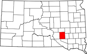 |
| Beadle County | 005 | Huron | 1879 | Buchard, Clark, Kingsbury, and Spink counties | William Henry Harrison Beadle, chief surveyor of Dakota Territory | 17,398 | 1,259 sq mi (3,261 km2) | 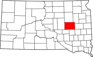 |
| Bennett County | 007 | Martin | 1909 | Lugenbeel, Oglala Lakota, Washabaugh, and Washington counties | Granville G. Bennett, justice of the Supreme Court for the Dakota Territory | 3,431 | 1,185 sq mi (3,069 km2) | 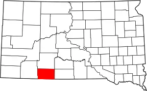 |
| Bon Homme County | 009 | Tyndall | 1862 | Unorganized territory | French phrase meaning "good man" | 7,070 | 563 sq mi (1,458 km2) | 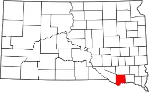 |
| Brookings County | 011 | Brookings | 1862 | Unorganized territory | Wilmot Brookings (1830 - 1905), Dakota Territory Supreme Court justice | 31,965 | 794 sq mi (2,056 km2) | 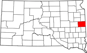 |
| Brown County | 013 | Aberdeen | 1879 | Beadle County | Alfred Brown, territorial legislator | 36,531 | 1,713 sq mi (4,437 km2) | 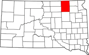 |
| Brule County | 015 | Chamberlain | 1875 | Charles Mix County | Brulé Sioux Native Americans | 5,255 | 819 sq mi (2,121 km2) | 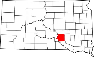 |
| Buffalo County | 017 | Gann Valley | 1873 | Unorganized territory | American Bison | 1,912 | 471 sq mi (1,220 km2) | 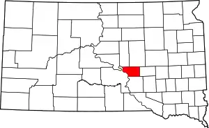 |
| Butte County | 019 | Belle Fourche | 1883 | Harding | Buttes in the region | 10,110 | 2,249 sq mi (5,825 km2) | 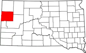 |
| Campbell County | 021 | Mound City | 1873 | Buffalo | Norman B. Campbell, territorial legislator | 1,466 | 736 sq mi (1,906 km2) | 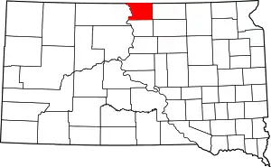 |
| Charles Mix County | 023 | Lake Andes | 1862 | Unorganized territory | Charles Eli Mix, commissioner of Indian Affairs | 9,129 | 1,098 sq mi (2,844 km2) | 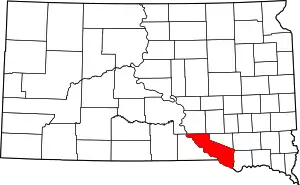 |
| Clark County | 025 | Clark | 1873 | Hanson | Newton Clark, territorial legislator | 3,691 | 958 sq mi (2,481 km2) | 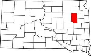 |
| Clay County | 027 | Vermillion | 1862 | Unorganized territory | Henry Clay (1777 - 1852), U.S. Senator from Kentucky and prominent 19th Century political figure | 13,864 | 412 sq mi (1,067 km2) | 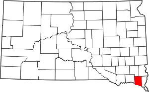 |
| Codington County | 029 | Watertown | 1877 | Indian lands | Reverend G.S. Codington, territorial legislator | 27,227 | 688 sq mi (1,782 km2) | 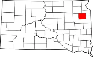 |
| Corson County | 031 | McIntosh | 1909 | Indian lands | Dighton Corson, a Justice of the South Dakota Supreme Court | 4,050 | 2,473 sq mi (6,405 km2) | 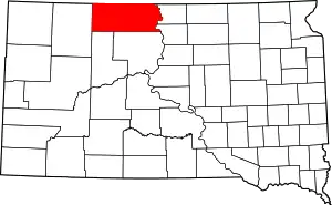 |
| Custer County | 033 | Custer | 1875 | Indian lands | General George Armstrong Custer (1839 - 1876), key figure in the Indian Wars | 8,216 | 1,558 sq mi (4,035 km2) | 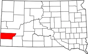 |
| Davison County | 035 | Mitchell | 1873 | Hanson | Henry C. Davison, prominent merchant and early settler | 19,504 | 436 sq mi (1,129 km2) | 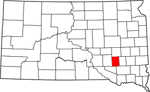 |
| Day County | 037 | Webster | 1879 | Clark | Merrit H. Day, territorial legislator | 5,710 | 1,029 sq mi (2,665 km2) | 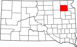 |
| Deuel County | 039 | Clear Lake | 1862 | Brookings | Jacob S. Deuel, territorial legislator | 4,364 | 624 sq mi (1,616 km2) | 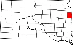 |
| Dewey County | 041 | Timber Lake | 1873 | Armstrong County and Indian lands | William P. Dewey, territorial surveyor-general | 5,301 | 2,303 sq mi (5,965 km2) | 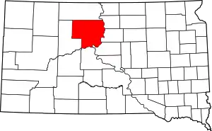 |
| Douglas County | 043 | Armour | 1873 | Charles Mix | Stephen A. Douglas (1813 - 1861), U.S. Senator from Illinois and advocate of popular sovereignty as a middle ground in the slavery debate | 3,002 | 434 sq mi (1,124 km2) | 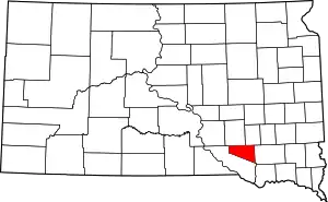 |
| Edmunds County | 045 | Ipswich | 1873 | Buffalo | Newton Edmunds, Governor of Dakota Territory | 4,071 | 1,146 sq mi (2,968 km2) | 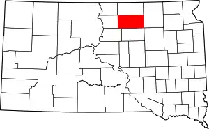 |
| Fall River County | 047 | Hot Springs | 1883 | Custer | Fall River | 7,094 | 1,740 sq mi (4,507 km2) | 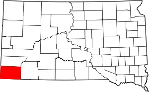 |
| Faulk County | 049 | Faulkton | 1873 | Unorganized lands | Andrew Jackson Faulk, Governor of Dakota Territory | 2,364 | 1,000 sq mi (2,590 km2) | 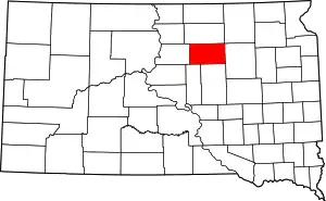 |
| Grant County | 051 | Milbank | 1873 | Codington and Deuel counties | Ulysses S. Grant (1822 - 1885), U.S. President and American Civil War general | 7,356 | 682 sq mi (1,766 km2) | 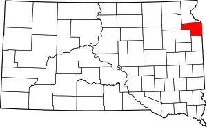 |
| Gregory County | 053 | Burke | 1862 | Unorganized territory | John Shaw Gregory, territorial legislator | 4,271 | 1,016 sq mi (2,631 km2) | 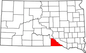 |
| Haakon County | 055 | Philip | 1914 | Stanley County | King Haakon VII of Norway | 1,937 | 1,813 sq mi (4,696 km2) | 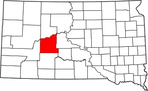 |
| Hamlin County | 057 | Hayti | 1873 | Deuel County | Hannibal Hamlin, Vice-President and United States Senator from Maine | 5,903 | 511 sq mi (1,323 km2) | 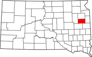 |
| Hand County | 059 | Miller | 1873 | Buffalo County | George H. Hand, territorial legislator | 3,431 | 1,437 sq mi (3,722 km2) | 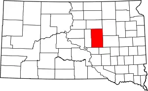 |
| Hanson County | 061 | Alexandria | 1873 | Buffalo and Deuel counties | Joseph R. Hanson, army major in the Indian Wars and early settler | 3,331 | 435 sq mi (1,127 km2) | 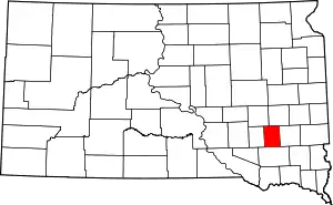 |
| Harding County | 063 | Buffalo | 1909 | Unorganized lands | J.A. Harding, Speaker of the House for Dakota Territory | 1,255 | 2,671 sq mi (6,918 km2) | 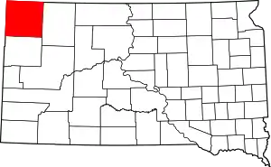 |
| Hughes County | 065 | Pierre | 1880 | Buffalo County | Alexander Hughes, territorial legislator | 17,022 | 741 sq mi (1,919 km2) | 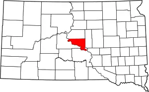 |
| Hutchinson County | 067 | Olivet | 1862 | Unorganized territory | John Hutchinson, territorial legislator | 7,343 | 813 sq mi (2,106 km2) | 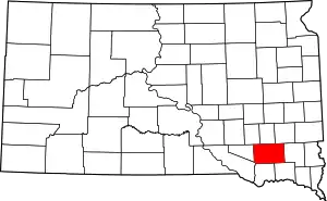 |
| Hyde County | 069 | Highmore | 1873 | Buffalo County | James Hyde, territorial legislator | 1,420 | 861 sq mi (2,230 km2) | 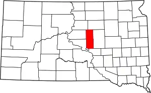 |
| Jackson County | 071 | Kadoka | 1914 | Stanley County | J.R. Jackson, territorial legislator | 3,031 | 1,869 sq mi (4,841 km2) | 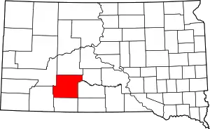 |
| Jerauld County | 073 | Wessington Springs | 1883 | Aurora County | H.A. Jerauld, territorial legislator | 2,070 | 530 sq mi (1,373 km2) | 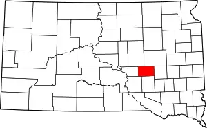 |
| Jones County | 075 | Murdo | 1916 | Lyman County | George W. Jones, territorial legislator | 1,006 | 971 sq mi (2,515 km2) | 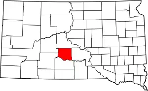 |
| Kingsbury County | 077 | De Smet | 1873 | Hanson County | George W. Kingsbury and T.A. Kingsbury, brothers and territorial legislators | 5,148 | 838 sq mi (2,170 km2) | 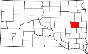 |
| Lake County | 079 | Madison | 1873 | Brookings and Hanson counties | Lakes within the county | 11,200 | 563 sq mi (1,458 km2) | 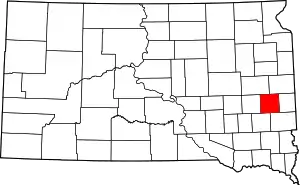 |
| Lawrence County | 081 | Deadwood | 1875 | Unorganized territory | John Lawrence (1839 - 1889), territorial legislator | 24,097 | 800 sq mi (2,072 km2) | 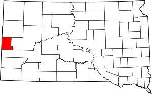 |
| Lincoln County | 083 | Canton | 1867 | Unorganized territory | Abraham Lincoln, the 16th President of the United States,[5] or, possibly, Lincoln County, Maine. | 44,828 | 578 sq mi (1,497 km2) | 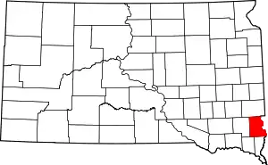 |
| Lyman County | 085 | Kennebec | 1873 | Unorganized territory | W.P. Lyman, territorial legislator | 3,755 | 1,640 sq mi (4,248 km2) | 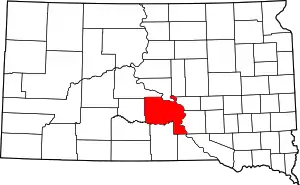 |
| Marshall County | 091 | Britton | 1885 | Day County | Marshall Vincent, Day County Commissioner | 4,656 | 839 sq mi (2,173 km2) | 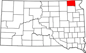 |
| McCook County | 087 | Salem | 1873 | Hanson County | Edwin McCook, Secretary of Dakota Territory | 5,618 | 575 sq mi (1,489 km2) | 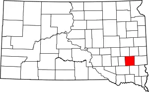 |
| McPherson County | 089 | Leola | 1873 | Buffalo County | James B. McPherson (1828 - 1864), Civil War general | 2,459 | 1,137 sq mi (2,945 km2) | 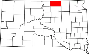 |
| Meade County | 093 | Sturgis | 1889 | Lawrence County | George Meade (1815 - 1872), Civil War general | 25,434 | 3,471 sq mi (8,990 km2) | 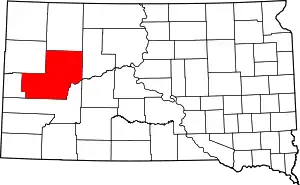 |
| Mellette County | 095 | White River | 1909 | Lyman County | Arthur C. Mellette, first Governor of South Dakota | 2,048 | 1,307 sq mi (3,385 km2) | 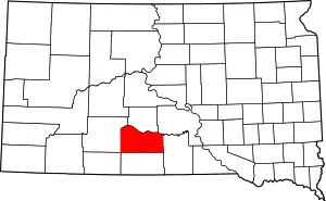 |
| Miner County | 097 | Howard | 1873 | Hanson County | Nelson Miner and Ephriam Miner, brothers and territorial legislators | 2,389 | 570 sq mi (1,476 km2) | 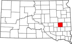 |
| Minnehaha County | 099 | Sioux Falls | 1862 | Unorganized territory | Sioux term for waterfall | 169,468 | 809 sq mi (2,095 km2) | 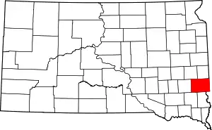 |
| Moody County | 101 | Flandreau | 1873 | Brookings and Minnehaha counties | Gideon C. Moody, Speaker of the House for Dakota Territory | 6,486 | 520 sq mi (1,347 km2) | 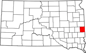 |
| Oglala Lakota County | 102 | 1875 | Fall River County | Oglala Lakota tribe | 13,586 | 2,094 sq mi (5,423 km2) | 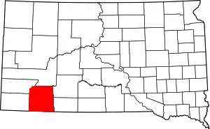 | |
| Pennington County | 103 | Rapid City | 1875 | Unorganized territory | John L. Pennington (1829 - 1900), Governor of Dakota Territory | 100,948 | 2,776 sq mi (7,190 km2) | 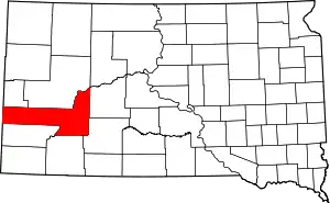 |
| Perkins County | 105 | Bison | 1909 | Butte and Harding counties | Henry E. Perkins, state senator | 2,982 | 2,872 sq mi (7,438 km2) | 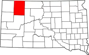 |
| Potter County | 107 | Gettysburg | 1875 | Buffalo County | Joel A. Potter, territorial legislator | 2,329 | 866 sq mi (2,243 km2) | 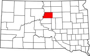 |
| Roberts County | 109 | Sisseton | 1883 | Grant County | S.G. Roberts, territorial legislator | 10,149 | 1,101 sq mi (2,852 km2) | 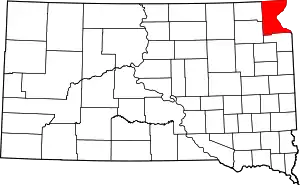 |
| Sanborn County | 111 | Woonsocket | 1883 | Miner County | George W. Sanborn, president of the Milwaukee Railroad | 2,355 | 569 sq mi (1,474 km2) | 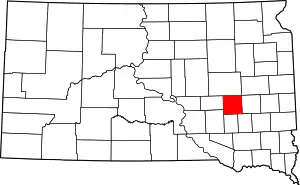 |
| Spink County | 115 | Redfield | 1873 | Hanson County | Solomon Spink, Secretary of Dakota Territory | 6,451 | 1,504 sq mi (3,895 km2) | 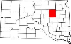 |
| Stanley County | 117 | Fort Pierre | 1873 | Unorganized territory | David S. Stanley, commander of Fort Sully | 2,966 | 1,443 sq mi (3,737 km2) | 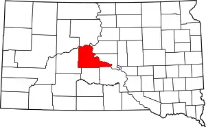 |
| Sully County | 119 | Onida | 1873 | Potter County | Fort Sully, itself named after General Alfred Sully | 1,373 | 1,007 sq mi (2,608 km2) | 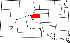 |
| Todd County | 121 | 1909 | Meyer and Tripp counties | John Blair Smith Todd, territorial delegate to Congress | 9,612 | 1,388 sq mi (3,595 km2) | 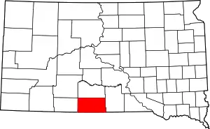 | |
| Tripp County | 123 | Winner | 1873 | Unorganized territory | Bartlett Tripp, Chief Justice of the Dakota Territorial Supreme Court | 5,644 | 1,614 sq mi (4,180 km2) | 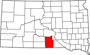 |
| Turner County | 125 | Parker | 1871 | Lincoln County | John W. Turner, territorial legislator | 8,347 | 617 sq mi (1,598 km2) | 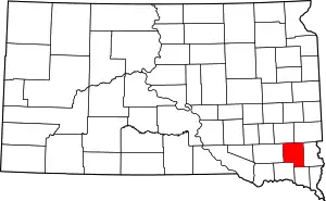 |
| Union County | 127 | Elk Point | 1862 | Unorganized territory | The union of the American states | 14,399 | 460 sq mi (1,191 km2) | 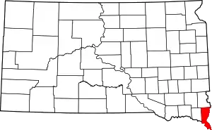 |
| Walworth County | 129 | Selby | 1873 | Buffalo County | Walworth County, Wisconsin | 5,438 | 708 sq mi (1,834 km2) | 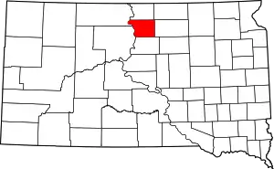 |
| Yankton County | 135 | Yankton | 1862 | Unorganized territory | Yankton Sioux Native Americans | 22,438 | 522 sq mi (1,352 km2) | 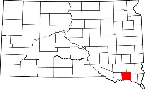 |
| Ziebach County | 137 | Dupree | 1911 | Armstrong, Schnasse, and Sterling counties | Frank M. Ziebach, publisher and army major during the Indian Wars | 2,801 | 1,962 sq mi (5,082 km2) | 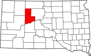 |
Former names
- Shannon County: renamed Oglala Lakota County in 2015
- Boreman County: Renamed Corson County in 1909
- Mandan County: Renamed Lawrence County
- Pratt County: Renamed Jones County
Former counties
- Armstrong County (1883–1952): Created by Dakota Territory as Pyatt County in 1883 from Cheyenne, Rusk (Dewey), and Stanley Counties. Renamed Armstrong in 1895. The western half was annexed to form part of the second Ziebach County, in 1911. The remainder was annexed into Dewey in 1952.
- Ashmore County
- Big Sioux County
- Bramble County
- Bruguier County
- Burchard County
- Burdick County
- Cheyenne County
- Choteau County: Abolished when it merged into Perkins County along with Martin, Rinehart and Wagner Counties.
- Cole County: organized in 1862, was named for Austin Cole, who was a member of the first Territorial Legislature. Two years later, the boundaries were rearranged and the name changed to Union because of sentiment for the Union side of the civil war.
- Cragin County
- Delano County: Absorbed by Meade County
- Ewing County (1889–1890): Created upon statehood. Abolished one year later, when it became the northern half of Harding County.
- Forsythe County
- Greely County, South Dakota
- Jayne County
- Lugenbeel County (1875–1909): Created by Dakota Territory from unorganized lands and Meyer and Pratt Counties in 1875. Abolished in 1909 when it became part of Bennett and Todd Counties.
- Martin County: Abolished when it merged into Perkins County along with Choteau, Rinehart and Wagner Counties.
- Meyer County
- Midway County
- Mills County
- Nowlin County (1883–1898): Created by Dakota Territory in 1883 from Cheyenne and White River Counties. Abolished in 1898 when it became part of Haakon County.
- Presho County: Absorbed by Lyman County
- Pyatt County (1883–1895): Created by Dakota Territory from unorganized lands in 1883. Renamed Armstrong in 1895. Later divided between the revived Ziebach County and Dewey County.
- Rinehart County: Abolished when it merged into Perkins County along with Choteau, Martin, and Wagner Counties.
- Rusk County
- Schnasse County (1883–1911): Created by Dakota Territory from unorganized lands and part of Boreman County in 1883. Later absorbed into Boreman and the revived Ziebach Counties
- Scobey County: Absorbed by Meade County
- Sterling County (1883–1911): Created by Dakota Territory from Cheyenne County. Abolished in 1911 when it became part of Haakon and Ziebach Counties
- Stone County
- Thompson County
- Wagner County: Abolished when it merged into Perkins County along with Choteau, Martin, and Rinehart Counties.
- Washabaugh County (1883–1983): South Dakota's most recent county to be eliminated. Created by Dakota Territory in 1883. Abolished in 1983 when it was merged with Jackson County.
- Washington County (1888–1943): Abolished in 1943 when it was divided between Pennington and Shannon Counties.
- Wetmore County
- White River County
- Wood County
- Ziebach County (1889–1890): Created in 1889, upon statehood. Abolished in 1890, becoming the eastern portion of Pennington County. The name was revived in 1911, when a second Ziebach County was created from parts of Sterling, Schnasse and Pyatt Counties.
Population density map
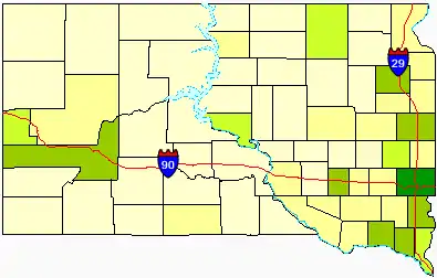
Map showing the density of South Dakota's counties
Darker colors indicate heavier density.
See also
List of US counties
References
- "South Dakota Counties, Regions, Tourism and State Index". Global Index. Archived from the original on January 2, 2006. Retrieved February 5, 2006.
- "EPA County FIPS Code Listing". Environmental Protection Agency. Retrieved May 1, 2008.
- "NACo - Find a county". National Association of Counties. Archived from the original on April 10, 2005. Retrieved May 1, 2008.
- "South Dakota". USA Today. Retrieved April 2, 2011.
- Gannett, Henry (1905). The Origin of Certain Place Names in the United States. US Government Printing Office. p. 187.
- Long, John H. (2006). "Dakota Territory, South Dakota, and North Dakota: Individual County Chronologies". Dakota Territory Atlas of Historical County Boundaries. The Newberry Library. Archived from the original on November 11, 2007.
- Long, John H. (2006). "South Dakota: Consolidated Chronology of State and County Boundaries". South Dakota Atlas of Historical County Boundaries. The Newberry Library. Archived from the original on July 27, 2010.

This article is issued from Wikipedia. The text is licensed under Creative Commons - Attribution - Sharealike. Additional terms may apply for the media files.