Milford Sound (village)
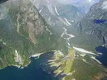
Milford Sound (Māori: Piopiotahi) is a small village located deep within Fiordland National Park in the Southland region of New Zealand. It is located at the head of the fiord also called Milford Sound. The village and fiord are one of the most visited places in New Zealand, receiving about one million day visitors per year.
Milford Sound
Piopiotahi | |
|---|---|
 Milford Sound visitor centre and wharf | |
 Milford Sound | |
| Coordinates: 44°40.23′S 167°55.30′E | |
| Country | |
| Island | South Island |
| Region | Southland region |
| Territorial authorities of New Zealand | Southland District |
| Population (2018) | |
| • Total | 102 |
| Time zone | UTC+12 (NZST) |
| • Summer (DST) | UTC+13 (NZDT) |
| Postcode | 0741 |
| Area code(s) | 03 |
| Local iwi | Ngāi Tahu |
History
Māori were mostly mobile and there is no evidence of permanent settlement in this location.[1][2]
The first European person to live at Milford Sound was the explorer and former soldier Donald Sutherland (1843 or 1844 – 1919), who arrived on 3 December 1877 and lived there for the rest of his life. The nearby Sutherland Falls and Te Hāpua / Sutherland Sound are named after him. After Sutherland married in 1890, he and his wife built an accommodation house; Milford Sound was visited by steamers twice a year during the 1880s. The government paid him to build a track to Sutherland Falls and in his first season in 1888/89, 40 tourists visited. In the following season, this increased to 70 tourists. His widow sold their accommodation house to the government in 1922.[3]
Quintin McKinnon (1851–1892) was tasked by the Otago Survey Department with achieving land access to Milford Sound. He was successful in finding a route over what is now called Mackinnon Pass, with the route itself now known as the Milford Track. This was the first access by foot known to Europeans; Māori had held that knowledge for centuries beforehand.[4]
Road access to Milford Sound was first envisaged by William H. Homer some time after he and George Barber discovered the Homer Saddle in 1889. It was Homer who suggested that a tunnel should be built underneath the pass as it was located at a height of 1,375 metres (4,511 ft)[5] but it was not until 1935 that the project was started. Progress was slow and it took until 1953 that Homer Tunnel was opened. After this road had been achieved, tourism to Milford Sound increased exponentially.[1] Milford Sound is the terminus for the road—State Highway 94 but also known as Milford Road—which is administered by the NZ Transport Agency. Up until the 1970s, the road was closed over winter but is now open year-round.[6] Milford Sound Airport has operated since 1952 and caters for up to twin-engine aircraft sized planes.[7]
Milford Sound today
At an annual average of over 6,800 millimetres (270 in) of rain with 182 rain days, Milford Sound is the wettest permanently lived in settlement in New Zealand. The heavier the rain, the more spectacular the waterfalls, with the Lady Bowen Falls closest to the village.[8] Most tourists visiting Milford Sound are day tourists and just one lodge provides overnight accommodation. As the settlement is located in a national park, camping is not permitted.[9] Most tourists reach Milford Sound by tour coach from Queenstown and with an eight-hour return trip, the village is only busy either side of lunchtime. Some tourists start their journey in Te Anau, which at four hours return is much closer.[10] Annual visitor numbers were expected to exceed one million for the first time in 2019.[11]
Few people live permanently in Milford Sound. The population of the area at the 2018 census was 102.[12] The village gets its drinking water from the Bowen River and this river also feeds a small hydroelectric plant for power supply.[13]
References
- Grant, David (25 May 2015). "Southland places – Milford Sound and north". Te Ara: The Encyclopedia of New Zealand. Retrieved 5 August 2020.
- "Milford Sound history". Entrada Travel Group. Retrieved 5 August 2020.
- Parham, W. T. "Sutherland, Donald". Dictionary of New Zealand Biography. Ministry for Culture and Heritage. Retrieved 5 August 2020.
- McLintock, A. H., ed. (1966). "McKinnon, Quintin McPherson". An Encyclopaedia of New Zealand. Ministry for Culture and Heritage / Te Manatū Taonga. Retrieved 4 August 2020.
- "Place name detail: Homer Saddle". New Zealand Gazetteer. New Zealand Geographic Board. Retrieved 5 August 2020.
- "SH94 Milford Road". NZ Transport Agency. Retrieved 5 August 2020.
- "Airport history". Queenstown Airport. Retrieved 5 August 2020.
- "Milford Sound weather". Entrada Travel Group. Retrieved 5 August 2020.
- "Milford Sound accommodation". Entrada Travel Group. Retrieved 5 August 2020.
- "Milford Sound". Tourism New Zealand. Retrieved 5 August 2020.
- Harding, Evan (28 June 2017). "Milford Sound set to top 1 million visitors in 2019". The Southland Times. Retrieved 5 August 2020.
- "Meshblock Electoral Populations 2020 for proposed boundaries data". Statistics New Zealand. April 2020. Meshblock 3174900.
- "Hydro generation". Milford Sound Infrastructure. Retrieved 5 August 2020.