List of islands of New Zealand
New Zealand consists of many islands, estimated around six hundred,[1] mainly remnants of a larger land mass now beneath the sea. The following is a list of islands of New Zealand.
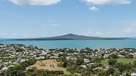
.jpg.webp)
Each of the two larger main islands – where most of the population lives – has two official names, in English and in the Māori language. They are the North Island or Te Ika-a-Māui, and the South Island or Te Waipounamu.[2] Various Māori iwi sometimes use different names, with some preferring to call the South Island Te Waka o Aoraki.[3] The islands are separated by Cook Strait. The South Island is sometimes informally referred to as the "mainland",[4] especially by its residents, because it is somewhat larger, albeit with a smaller population. However, in general practice, the "mainland" refers to the North Island and South Island collectively, in contrast with the smaller offshore islands.
Stewart Island or Rakiura, in the south, is the largest of the smaller islands, although Waiheke Island in the urban Auckland Region has the largest population of the smaller islands.
Listed by size
The following table lists the largest islands of New Zealand by size. (The associated Cook Islands, Niue, Tokelau, and islands of the Antarctic Ross Dependency are excluded.) River delta islands such as Rakaia Island (25.7 km2 (9.9 sq mi)),[5] Fereday Island, Rangitata Island, and Inch Clutha (approximately 15 km2 (5.8 sq mi), 30 km2 (12 sq mi), and 35 km2 (14 sq mi) respectively) are also omitted, as are temporary islands in braided river channels and tidal islands such as Rabbit Island, Nelson (17 km2 (6.6 sq mi)). The country's largest island within a lake, Pomona Island, has an area of just 2.6 km2 (1.0 sq mi).[6]
| Rank | English name | Māori name | Area (km2) | Area (sq mi) | % of NZ area | Population |
|---|---|---|---|---|---|---|
| 1 | South Island | Te Waipounamu, Te Wahi Pounamu, Te Waka a Māui, Te Waka o Aoraki | 150,437 | 58,084 | 56.2% | 1,187,300 |
| 2 | North Island | Te Ika-a-Māui | 113,729 | 43,911 | 42.3% | 3,896,200 |
| 3 | Stewart Island | Rakiura, Te Punga o Te Waka-a-Māui | 1,683 | 650 | 0.6% | 400 |
| 4 | Chatham Island | Rekohu (Moriori); Wharekauri (Māori) | 900 | 350 | 0.3% | 600 |
| 5 | Auckland Island | Mauka Huka | 510 | 200 | 0.2% | 0 |
| 6 | Great Barrier Island | Aotea | 285 | 110 | 0.1% | 850 |
| 7 | Resolution Island | Tau Moana | 208.87 | 80.65 | 0.1% | 0 |
| 8 | D'Urville Island | Rangitoto Ki Te Tonga | 150 | 58 | <0.1% | About 52[7] |
| 9 | Campbell Island | Motu Ihupuku | 115 | 44 | <0.1% | 0 |
| 10 | Adams Island | 100 | 39 | <0.1% | 0 | |
| 11 | Waiheke Island | Waiheke | 92 | 36 | <0.1% | 9,660 |
| 12 | Secretary Island | Ka Tu-waewae-o-Tu | 81.4 | 31.4 | <0.1% | 0 |
| 13 | Arapaoa Island | Arapaoa | 75 | 29 | <0.1% | 50 |
| 14 | Pitt Island | Rangiaotea (Moriori) or Rangiauria (Maori) | 62 | 24 | <0.1% | 38 |
| 15 | Matakana Island | Matakana | 60 | 23 | <0.1% | 225 |
| 16 | Raoul Island | Rangitahua | 29.4 | 11.4 | <0.1% | 6 |
| 17 | Little Barrier Island | Hauturu | 28 | 11 | ~0.0% | 0 |
| 18 | Rangitoto Island | Rangitoto | 23.1 | 8.9 | ~0.0% | 0 |
| 19 | Antipodes Island | 20 | 7.7 | ~0.0% | 0 | |
| 20 | Kapiti Island | Kapiti | 19.7 | 7.6 | ~0.0% | 0 |
| 21 | Kawau Island | Kawau | 19 | 7.3 | ~0.0% | 81 |
| 22 | Long Island, Southland | Motu Roa | 18.99 | 7.33 | ~0.0% | 0 |
| 23 | Cooper Island | Ure Toto | 17.79 | 6.87 | ~0.0% | 0 |
| 24 | Ponui Island | Ponui | 17.7 | 6.8 | ~0.0% | 0 |
| 25 | Great Mercury Island | Ahuahu | 17.2 | 6.6 | ~0.0% | 0 |
| 26 | Ruapuke Island | Ruapuke | 16 | 6.2 | ~0.0% | 0 |
| 27 | Motutapu Island | Motutapu | 15.1 | 5.8 | ~0.0% | 0 |
| 28 | Codfish Island | Whenua Hou | 14 | 5.4 | ~0.0% | 0 |
| 29 | Mayor Island | Tuhua | 13 | 5.0 | ~0.0% | 0 |
| 30 | Coal Island | Te Puka-Hereka | 11.6 | 4.5 | ~0.0% | 0 |
| 31 | Anchor Island | Pukenui | 11.37 | 4.39 | ~0.0% | 0 |
| 32 | Motiti Island | Motiti | 10 | 3.9 | ~0.0% | 27 |
| 33 | Big South Cape Island | Taukihepa | 9.4 | 3.6 | ~0.0% | 0 |
Listed by highest point
The following table lists the islands of New Zealand by their highest elevation. These islands are all in harbours or the open sea. The country's tallest island within a lake, Pomona Island, rises to 511 metres (1,677 ft) above sea level, which is about 333 metres (1,093 ft) above Lake Manapouri's normal lake level.
| Rank | Name of island | Highest point | Name of peak | Type of peak |
|---|---|---|---|---|
| 1 | South Island | 3,754 m (12,316 ft) | Aoraki/Mount Cook | Tectonic |
| 2 | North Island | 2,797 m (9,177 ft) | Mount Ruapehu | Volcanic |
| 3 | Secretary Island | 1,196 m (3,924 ft) | Mount Grono | Tectonic |
| 4 | Resolution Island | 1,069 m (3,507 ft) | Mount Clerke | Tectonic |
| 5 | Stewart Island | 980 m (3,220 ft) | Mount Anglem | Tectonic |
| 6 | D'Urville Island | 729 m (2,392 ft) | Attempt Hill | Tectonic |
| 7 | Little Barrier Island | 722 m (2,369 ft) | Mount Hauturu | Volcanic |
| 8 | Adams Island | 705 m (2,313 ft) | Mount Dick | Volcanic |
| 9 | Auckland Island | 659 m (2,162 ft) | Cavern Peak | Volcanic |
| 10 | Great Barrier Island | 627 m (2,057 ft) | Mount Hobson | Tectonic |
| 11 | Long Island, Southland | 620 m (2,030 ft) | Tectonic | |
| 12 | Campbell Island | 569 m (1,867 ft) | Mount Honey | Volcanic |
| 13 | Arapaoa Island | 559 m (1,834 ft) | Narawhia | Tectonic |
| 14 | Cooper Island | 523 m (1,716 ft) | Tectonic | |
| 15 | Kapiti Island | 521 m (1,709 ft) | Tuteremoana | Tectonic |
| 16 | Raoul Island | 516 m (1,693 ft) | Moumoukai Peak | Volcanic |
| 17= | Anchor Island | 417 m (1,368 ft) | Tectonic | |
| 17= | Taranga (Hen) Island | 417 m (1,368 ft) | The Pinnacles | Tectonic |
| 19 | Bauza Island | 383 m (1,257 ft) | Tectonic | |
| 20 | Maud Island/Te Hoiere | 368 m (1,207 ft) | Tectonic | |
| 21 | Antipodes Island | 366 m (1,201 ft) | Mount Galloway | Volcanic |
| 22 | Forsyth Island | 356 m (1,168 ft) | Tectonic | |
| 23 | Mayor Island | 355 m (1,165 ft) | Opuahau | Volcanic |
| 24 | Moutohora Island/Whale Island | 353 m (1,158 ft) | Motu Hara | Volcanic |
| 25 | Breaksea Island | 350 m (1,150 ft) | Tectonic | |
| 26 | Solander Island/Hautere | 330 m (1,080 ft) | Tectonic | |
| 27 | Whakaari / White Island | 321 m (1,053 ft) | Mount Gisborne | Volcanic |
| 28 | Chatham Island | 299 m (981 ft) | Volcanic | |
| 29 | Blumine Island | 298 m (978 ft) | Tectonic | |
| 30 | Manawatāwhi/Great Island (Three Kings Islands) | 295 m (968 ft) | Tectonic | |
| 31 | Mangere Island (Chatham Islands) | 292 m (958 ft) | Whakapa | Tectonic |
| 32 | Stephens Island/Takapourewa | 283 m (928 ft) | Tectonic | |
| 33 | Rangitoto Island | 260 m (850 ft) | Rangitoto | Volcanic |
| 34 | Coal Island | 251 m (823 ft) | Tectonic | |
| 35 | Codfish Island | 250 m (820 ft) | Tectonic | |
| 36 | Nukuwaiata Island (Chetwode Islands) | 247 m (810 ft) | Tectonic | |
| 37 | Pitt Island/Rangiauria | 241 m (791 ft) | Waihere | Tectonic |
| 38 | Macauley Island (Kermadec Islands) | 238 m (781 ft) | Mount Haszard | Volcanic |
| 39 | Taukihepa / Big South Cape Island | 235 m (771 ft) | Tectonic | |
| 40 | Whatupuke Island (Hen and Chicken Islands) | 234 m (768 ft) | Tectonic | |
| 41= | Great Mercury Island | 231 m (758 ft) | Mount Mohi | Volcanic |
| 41= | Waiheke Island | 231 m (758 ft) | Maunganui | Tectonic |
| 43 | Jacquemart Island (Campbell Islands) | 229 m (751 ft) | Volcanic | |
| 44 | Wakaterepapanui Island (Rangitoto Islands) | 225 m (738 ft) | Tectonic | |
| 45 | South East Island/Rangatira (Chatham Islands) | 224 m (735 ft) | Tectonic | |
| 46 | Rakitu Island | 220 m (720 ft) | Tectonic | |
| 47 | Aorangi Island | 216 m (709 ft) | Tectonic | |
| 48= | Cuvier Island | 214 m (702 ft) | Tectonic | |
| 48= | Little Mangere Island (Chatham Islands) | 214 m (702 ft) | Whakapa | Tectonic |
| 50 | Moekawa/South West Island (Three Kings Islands) | 207 m (679 ft) | Tectonic | |
| 51 | Bollons Island (Antipodes Islands) | 202 m (663 ft) | Volcanic | |
| 52 | Indian Island | 196 m (643 ft) | Tectonic | |
| 53 | Tawhiti Rahi Island (Poor Knights Islands) | 191 m (627 ft) | Tectonic | |
| 54 | Tinui Island (Rangitoto Islands) | 190 m (620 ft) | Tectonic | |
| 55 | Matapara / Pickersgill Island | 186 m (610 ft) | Tectonic | |
| 56= | Great Island | 185 m (607 ft) | Tectonic | |
| 56= | Kaikoura Island | 185 m (607 ft) | Mitre Peak | Tectonic |
| 56= | Pearl Island (off Stewart Island) | 185 m (607 ft) | Tectonic | |
| 59 | Coppermine Island (Hen and Chicken Islands) | 184 m (604 ft) | Huarewa | Tectonic |
| 60 | Kawau Island | 182 m (597 ft) | Grey Heights | Tectonic |
| 61 | Te Kakaho Island (Chetwode Islands) | 179 m (587 ft) | Tectonic | |
| 62 | Motukawanui Island | 177 m (581 ft) | Tectonic | |
| 63 | Ōhau/West Island (Three Kings Islands) | 177 m (581 ft) | Tectonic | |
| 64 | Motutapere Island (off Coromandel) | 175 m (574 ft) | Tectonic | |
| 65 | Ponui Island | 173 m (568 ft) | Ponui | Tectonic |
| 66 | Motuoruhi Island (off Coromandel) | 169 m (554 ft) | Tectonic | |
| 67 | Lady Alice Island (Hen and Chicken Islands) | 158 m (518 ft) | Tectonic | |
| 68 | The Castle/Rangiwheau (Chatham Islands) | 156 m (512 ft) | Tectonic | |
| 69 | Long Island, Marlborough | 152 m (499 ft) | Tectonic | |
| 70 | Noble Island (off Stewart Island) | 154 m (505 ft) | Tectonic | |
| 71 | Chalky Island | 151 m (495 ft) | Tectonic | |
| 72= | Red Mercury Island | 150 m (490 ft) | Volcanic | |
| 72= | Puangiangi Island (Rangitoto Islands) | 150 m (490 ft) | Tectonic | |
In harbours and the open sea
- Adele Island
- Aiguilles Island
- Aldermen Islands
- Allports Island
- Amerikiwhati Island
- Anatakupu Island
- Anchor Island
- Anchorage Island
- Aorangaia Island
- Araara Island
- Arakaninihi Island
- Arapaoa Island
- Aroha Island
- Awarua Rock
- Bare Island
- Bauza Island
- Bells Island
- Bench Island
- Bests Island
- Big South Cape Island
- Blumine Island
- Breaksea Island
- The Brothers
- Browns Island
- Calliope Island, Whangarei Heads
- Catherine Island, Charles Sound
- Cavalli Islands
- Chalky Island
- Chetwode Islands
- Coal Island
- Codfish Island/Whenuahou
- Cooper Island
- Dog Island
- Cuvier Island
- D'Urville Island
- Dragon Island
- East Island / Whangaokeno
- Eleanor Island, Charles Sound
- Elizabeth Island
- Fanny Island, Charles Sound
- Fisherman Island
- Forsyth Island
- Frenchman Island, Whangarei Heads
- Gannet Island
- Goat Island, Auckland
- Goat Island, Otago Harbour
- Goat Island / Te Mapoutahi
- Great Barrier Island/Aotea
- Great Island
- Green Island
- Guano Island, Whangarei Heads
- Hen and Chicken Islands
- High Island
- Herald Island
- Indian Island
- Kaikoura Island
- Kapiti Island
- Kawau Island
- King Billy Island
- Kopuahingahinga Island, Manukau Harbour
- Little Barrier Island (Hauturu)
- Long Island, Marlborough
- Long Island, Southland
- Mahurangi Island (Goat Island)
- Mākaro / Ward Island
- Mana Island
- Matakana Island
- Matiu / Somes Island
- Maud Island/Te Hoiere
- Mauitaha Island, Whangarei Heads
- Mayor Island/Tuhua
- Mercury Islands
- Mokohinau Islands
- Mokopuna Island
- Motiti Island
- Motuara Island
- Motuarohia Island
- Motueka Island (Pigeon Island)
- Motuhoa Island, Tauranga Harbour
- Motuihe Island
- Motukaroro Island
- Motukawao Islands
- Motukiore Island, Parua Bay
- Motu Matakohe / Limestone Island
- Motunau Island
- Motuora Island
- Motuoroi Island
- Moturaka Island
- Moturata/Taieri Island
- Moturekareka Island
- Motutapu Island
- Moutohora Island/Whale Island
- Native Island
- Ngarango Otainui Island
- Ninepin Rock, Manukau Harbour
- Noble Island
- North Island
- Opahekeheke Island
- Open Bay Islands
- Pakatoa Island
- Pakihi Island
- Pararekau Island, Manukau Harbour
- Pearl Island
- Pepin Island (a tied island connected to the mainland)
- Piercy Island
- Ponui Island
- Poor Knights Islands
- Portland Island
- Pourewa Island
- Puketutu Island
- Putauhinu Island
- Quail Island
- Quarantine Island / Kamau Taurua
- Rabbit Island
- Rakino Island
- Rakitu Island
- Rangitoto Island
- Rangitoto Islands, Marlborough Sounds
- Raratoka Island
- Resolution Island
- Ripapa Island
- Rotoroa Island
- Rurima Rocks, including Rurima Island
- Ruapuke Island
- Secretary Island
- Shark Island, Manukau Harbour
- Shoe Island / Motuhoa
- Simmonds Islands
- Slipper Island
- South Island
- Stephens Island/Takapourewa
- Stephenson Island
- Stewart Island / Rakiura
- Sugar Loaf Islands
- Takangaroa Island
- Taputeranga Island
- Tarahiki Island
- Tarakanahi Island
- Tata Islands
- Tikitiki Island, (The Ninepin), Bay of Islands
- Tiritiri Matangi Island
- Titi/Muttonbird Islands
- Tonga Island
- Ulva Island
- Urupukapuka Island
- Waiheke Island
- Walker Island
- Watchman Island
- Whakaari/White Island
- Whanganui Island
- White Island (Otago)
- Wiroa Island, Manukau Harbour
In rivers and lakes
- Black Jacks Island (in Lake Benmore)
- Channel Islands (in Lake Manapouri)
- Dome Islands (in Lake Te Anau)
- Entrance Island (in Lake Te Anau)
- Fereday Island (in the Rakaia River delta)
- Harwich Island (in Lake Wānaka)
- Hidden Island (in Lake Wakatipu)
- Inch Clutha (in the Clutha River delta)
- Junction Island (in Lake Benmore)
- Karihoa Island (in Waikato River)
- Kaiwaka No.1 Island (in Waikato River delta)
- Kaiwaka No.2 Island (in Waikato River delta)
- Manutahi Island (in Waikato River)
- Mary Island (in Lake Hauroko)
- Mokoia Island (in Lake Rotorua)
- Motakorea Island (in Waikato River)
- Motuariki Island (in Lake Tekapo)
- Motukakako Island (in Waikato River delta)
- Motutaiko Island (in Lake Taupo)
- Moutoa Island (in the Whanganui River)
- Mou Tapu (in Lake Wānaka)
- Mou Waho (in Lake Wānaka)
- Motutieke Island (in Waikato River delta)
- Namuheiriro Island (in Waikato River)
- Ngāhinapōuri Island (in Waikato River delta)
- Opuawhanga Island (in Waikato River)
- Pigeon Island/Wāwāhi Waka (in Lake Wakatipu)
- Pig Island/Mātau (in Lake Wakatipu)
- Pomona Island (in Lake Manapouri)
- Puehunui Island (in Waikato River delta)
- Rakaia Island (in the Rakaia River delta)
- Rangitata Island (in the Rangitata River delta)
- Rona Island (in Lake Manapouri)
- Ruby Island (in Lake Wānaka)
- Silver Island (in Lake Hāwea)
- Stevensons Island/Te Peka Karara (in Lake Wānaka)
- Tarahanga Island (in Waikato River)
- Tawanui Island (in Waikato River delta)
- Te Kopura Island (in Waikato River)
- Te Toki Island (in Waikato River)
- Te Weranga Okapu Island (in Waikato River delta)
- Tree Island (in Lake Wakatipu)
- Whatamakiri Island (in Waikato River delta)
Outlying
New Zealand administers the following islands outside the main archipelago. Only the Chatham Islands have a permanent population although others also did in the past. Others host visitors for science, conservation, meteorological observation and tourism.
The New Zealand Subantarctic Islands are designated as a World Heritage Site.
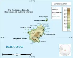
- Antipodes Islands
- Antipodes Island
- Bollons Island
- Auckland Islands
- Bounty Islands
- Campbell Island group
- Campbell Island
- Dent Island
- Folly Island (or Folly Islands)
- Jacquemart Island
- The Snares
Realm of New Zealand
The following islands are part of the Realm of New Zealand, but are not part of New Zealand proper:
Territorial claims
New Zealand also claims the Ross Dependency in Antarctica, including:
- the Balleny Islands
- Scott Island
- Roosevelt Island
- Coulman Island
- the Ross Archipelago
- Ross Island
- Beaufort Island
- White Island
- Black Island
- the Dellbridge Islands
- Inaccessible Island
- Tent Island
- Big Razorback
- Little Razorback
See also
- List of islands
- Geography of New Zealand
- Extreme points of New Zealand
References
- McSaveney, Eileen (24 September 2007). "Nearshore islands". Te Ara – the Encyclopedia of New Zealand.
- "Two official options for NZ island names". The New Zealand Herald. 10 October 2013. Retrieved 20 December 2018.
- Mein Smith, Philippa (2005). A Concise History of New Zealand. Australia: Cambridge University Press. p. 6. ISBN 0-521-54228-6.
- Meier, Cecile (10 September 2015). "South Island the true Mainland: Cecile Meier". Stuff.co.nz. Retrieved 16 December 2018.
- Taylor, Marie. Once-a-day milking next Turner challenge Archived 25 May 2012 at Archive.today, 1 May 2004.
- Pomona Island Charitable Trust, Department of Conservation. Retrieved 22 November 2010.
- Gerard Hindmarsh (2006). Discovering D'Urville, Heritage New Zealand, Winter 2006.