Millbourne, Edmonton
Millbourne is a community comprising four neighbourhoods within the northwest portion of Mill Woods in the City of Edmonton, Alberta, Canada. Neighbourhoods within the community include Lee Ridge,[5] Michaels Park,[6] Richfield[7] and Tweddle Place.[8] Community representation within Millbourne are split by two community leagues. The Lee Ridge and Richfield neighbourhoods are represented by the Leefield Community League,[9] while the Michaels Park and Tweddle Place neighbourhoods are represented by the North Millbourne Community League.[10]
Millbourne | |
|---|---|
Community | |
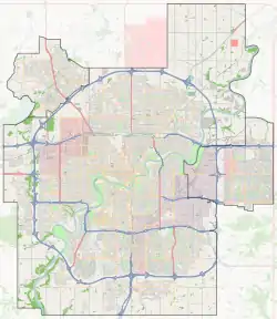
 Millbourne Location of Millbourne in Edmonton | |
| Coordinates: 53.473°N 113.452°W | |
| Country | |
| Province | |
| City | Edmonton |
| Quadrant[1] | NW |
| Ward[1] | 11 |
| Sector[2] | Southeast |
| Area[3] | Mill Woods |
| Government | |
| • Mayor | Don Iveson |
| • Administrative body | Edmonton City Council |
| • Councillor | Mike Nickel |
| Elevation | 687 m (2,254 ft) |
Millgate Transit Centre
Millgate Transit Centre | |
|---|---|
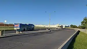
 Millgate Transit Centre in 2020. | |
| Platforms | 14 bus bays[11] |
| Construction | |
| Parking | No |
| Disabled access | Yes |
| Other information | |
| Website | Millgate Transit Centre |
The Millgate Transit Centre is located to the north of the community across Whitemud Drive on 86 Street. This transit centre has a passenger drop off area, a large shelter, vending machines and a pay phone. There are no washrooms or park & ride from this transit centre.[12]
The following bus routes serve the transit centre:[13]
| To/From | Routes |
|---|---|
| Abbottsfield Transit Centre | 8 |
| Bonnie Doon | 8, 15, 71 |
| Brander Gardens | 33 |
| Burnewood | 68 |
| Capilano Transit Centre | 84 |
| Coliseum Transit Centre | 8 |
| Downtown | 8, 15, 60, 61, 66, 68, 69, 71, 81, 87 |
| Eaux Claires Transit Centre | 15 |
| Government Centre Transit Centre | 71 |
| Kingsway/Royal Alex Transit Centre | 8 |
| Lakewood Transit Centre | 6, 8, 15, 66, 97 |
| Laurel | 370 |
| MacEwan | 8, 15, 60, 61, 68, 69, 97 |
| Meadows Transit Centre | 33, 69 |
| Mill Woods Transit Centre | 6, 8, 15, 60, 61, 66, 68, 69, 71, 72, 81, 97, 340, 361, 370 |
| NAIT | 8, 15, 97 |
| Northgate Transit Centre | 15 |
| Pylypow Industrial | 92 |
| Silver Berry | 72, 370 |
| Southgate Transit Centre | 6, 33 |
| Strathcona / Whyte Ave | 60, 61, 66, 68, 69, 81, 97 |
| Strathcona Industrial | 321, 340 |
| West Edmonton Mall Transit Centre | 33 |
School special routes that arrive/depart from Millgate Transit Centre include routes: 6S, 8S, 60S, 61S, 62S, 69S, and 87S.[14]
External links
References
- "City of Edmonton Wards & Standard Neighbourhoods" (PDF). City of Edmonton. Archived from the original (PDF) on December 16, 2011. Retrieved February 13, 2013.
- "Edmonton Developing and Planned Neighbourhoods, 2011" (PDF). City of Edmonton. Archived from the original (PDF) on March 26, 2014. Retrieved February 13, 2013.
- "City of Edmonton Plans in Effect" (PDF). City of Edmonton. November 2011. Archived from the original (PDF) on October 17, 2013. Retrieved February 13, 2013.
- "City Councillors". City of Edmonton. Retrieved February 13, 2013.
- "Lee Ridge Neighbourhood Profile" (PDF). City of Edmonton. Retrieved 2012-11-27.
- "Michaels Park Neighbourhood Profile" (PDF). City of Edmonton. Retrieved 2012-11-27.
- "Richfield Neighbourhood Profile" (PDF). City of Edmonton. Retrieved 2012-11-27.
- "Tweddle Place Neighbourhood Profile" (PDF). City of Edmonton. Retrieved 2012-11-27.
- "Leefield". Mill Woods Presidents' Council. Retrieved 2012-11-27.
- "North Millbourne". Mill Woods Presidents' Council. Retrieved 2012-11-27.
- "Millgate Transit Centre Map" (PDF). City of Edmonton. Retrieved 2 December 2018.
- "Millgate Transit Centre". City of Edmonton. Retrieved October 2, 2017.
- "Brochures in PDF". City of Edmonton. Retrieved 7 November 2019.
- "School Service: ETS Trip Planner". City of Edmonton. Retrieved 29 August 2019.