Mingha River
The Mingha River is a river of the Canterbury Region of New Zealand's South Island. It flows east then south from its origin on the slopes of Mt Temple, meeting the Bealey River 8 kilometres (5 mi) south of Arthur's Pass.
| Mingha River | |
|---|---|
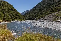 Mingha River close to Mingha Bivouac | |
| Location | |
| Country | New Zealand |
| Physical characteristics | |
| Source | |
| • location | Southern Alps |
| • elevation | 1,600 m (5,200 ft) |
| Mouth | |
• location | Bealey River |
• elevation | 670 m (2,200 ft) |
| Length | 11 km (6.8 mi) |
Together with Goat Pass, elevation 1,071 metres (3,514 ft), and the Deception River, the Mingha valley forms a route across the Southern Alps known as the Mingha/Deception. It is used for the mountain running segment of the annual Coast to Coast race.
See also
References
- "Place name detail: Mingha River". New Zealand Gazetteer. New Zealand Geographic Board. Retrieved 12 July 2009.
- New Zealand 1:50000 topographic map sheet BV20 - Otira
This article is issued from Wikipedia. The text is licensed under Creative Commons - Attribution - Sharealike. Additional terms may apply for the media files.
