Canterbury, New Zealand
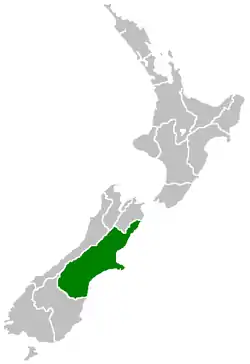
Canterbury (Māori: Waitaha) is a region of New Zealand, located in the central-eastern South Island. The region covers an area of 44,508 square kilometres (17,185 sq mi), and is home to a population of 645,900 (June 2020).[1]
Canterbury
Waitaha | |
|---|---|
| Canterbury Region | |
 Canterbury Region within New Zealand | |
| Coordinates: 43.6°S 172.0°E | |
| Country | |
| Island | South Island |
| Established | 1989 |
| Seat | Christchurch |
| Territorial authorities | |
| Government | |
| • Chairperson | Jenny Hughey (TPC) |
| Area | |
| • Region | 44,508 km2 (17,185 sq mi) |
| Population (June 2020)[1] | |
| • Region | 645,900 |
| • Density | 15/km2 (38/sq mi) |
| Demonym(s) | Cantabrian |
| Time zone | UTC+12 (NZST) |
| • Summer (DST) | UTC+13 (NZDT) |
| HDI (2017) | 0.926[2] very high · 3rd |
The region in its current form was established in 1989 during nationwide local government reforms. The Kaikoura District joined the region in 1992 following the abolition of the Nelson-Marlborough Regional Council.
Christchurch, the South Island's largest city and the country's second-largest urban area, is the seat of the region and home to 59 percent of the region's population. Other major towns and cities include Timaru, Ashburton, Rangiora and Rolleston.
History
Colonisation
In 1848, Edward Gibbon Wakefield, a Briton, and John Robert Godley, an Anglo-Irish aristocrat, founded the Canterbury Association to establish an Anglican colony in the South Island. The colony was based upon theories developed by Wakefield while in prison for eloping with a woman not-of-age. Due to ties to the University of Oxford, the Canterbury Association succeeded in raising sufficient funds and recruiting middle-class and upper-class settlers.[3] In April 1850, a preliminary group led by Godley landed at Port Cooper—modern-day Lyttelton Harbour—and established a port, housing and shops in preparation for the main body of settlers. In December 1850, the first wave of 750 settlers arrived at Lyttelton in a fleet of four ships.[3]
Following 1850, the province's economy developed with the introduction of sheep farming. The Canterbury region's tussock plains in particular were suitable for extensive sheep farming. Since they were highly valued by settlers for their meat and wool, there were over half a million sheep in the region by the early 1850s. By the 1860s, this figure had risen to three million.[3] During this period, the architect Benjamin Mountfort designed many civic and ecclesiastical buildings in the Gothic Revival style.
Canterbury Province
The Canterbury Province was formed in 1853 following the passing of the New Zealand Constitution Act 1852. It was formed from part of New Munster Province and covered the middle part of the South Island, stretching from the east coast to the west coast. The province was abolished, along with other provinces of New Zealand, when the Abolition of the Provinces Act came into force on 1 Nov 1876.[4] The modern Canterbury Region has slightly different boundaries, particularly in the north, where it includes some districts from the old Nelson Province.
September 2010
An earthquake with magnitude 7.1 occurred in the South Island of New Zealand at Saturday 04:35 am local time, 4 September 2010 (16:35 UTC, 3 September 2010).[5] The earthquake occurred at a depth of 10 kilometres (6.2 mi), and there were no fatalities.
The epicentre was located 40 kilometres (25 mi) west of Christchurch; 10 kilometres (6.2 mi) south-east of Darfield;[6] 190 kilometres (120 mi) south-southeast of Westport; 295 kilometres (183 mi) south-west of Wellington; and 320 kilometres (200 mi) north-northeast of Dunedin.
Sewers were damaged, gas and water lines were broken, and power to up to 75% of the city was disrupted.[7] Among the facilities impacted by lack of power was the Christchurch Hospital, which was forced to use emergency generators in the immediate aftermath of the quake.[7]
A local state of emergency was declared at 10:16 am on 4 September for the city, and evacuations of parts were planned to begin later in the day.[8] People inside the Christchurch city centre were evacuated, and the city's central business district remained closed until 5 September.[9] A curfew from 7 pm on 4 September to 7 am on 5 September was put in place.[10] The New Zealand Army was also deployed to assist police and enforce the curfew. All schools were closed until 8 September so they could be checked.
Christchurch International Airport was closed following the earthquake and flights in and out of it cancelled. It reopened at 1:30 pm following inspection of the main runway.[11]
The earthquake was reported to have caused widespread damage and power outages. 63 aftershocks were also reported in the first 48 hours with three registering 5.2 magnitude. Christchurch residents reported chimneys falling in through roofs, cracked ceilings and collapsed brick walls.[12] The total insurance costs of this event were estimated to reach up to $11 billion according to the New Zealand Treasury.[13][14]
February 2011
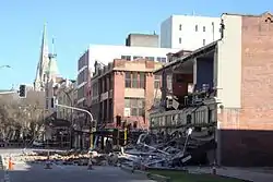
A large aftershock of magnitude 6.3 occurred on 22 February 2011 at 12:51 pm. It was centred just to the north of Lyttelton, 10 kilometres south east of Christchurch, at a depth of 5 km.[15] Although lower on the moment magnitude scale than the quake of September 2010, the intensity and violence of the ground shaking was measured to be VIII on the MMI and among the strongest ever recorded globally in an urban area due to the shallowness and proximity of the epicentre.[16] Early assessments indicated that about a third of the buildings in the Central Business District would have to be demolished.
In contrast to the September 2010 quake, the February 2011 earthquake struck on a busy weekday afternoon. This, along with the strength of the quakes, and the proximity to the city centre resulted in 181 deaths.[17]
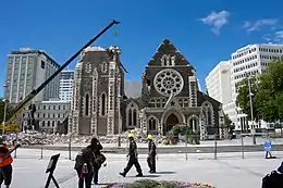
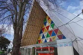
This event promptly resulted in the declaration of New Zealand's first National State of Emergency. Many buildings and landmarks were severely damaged, including the iconic Shag Rock and Christchurch Cathedral.
International bodies quickly offered assistance. Contingents of Urban Search and Rescue (USAR) soon arrived. Teams were provided by Australia, United States, Singapore, Britain, Taiwan, Japan and China.
The Royal New Zealand Navy was involved immediately. HMNZS Canterbury, which was docked at Lyttelton when the quake struck, was involved in providing local community assistance, in particular by providing hot meals.
After inspection, the runway at Christchurch Airport was found to be in good order. Due to the demand of citizens wishing to leave the city, the national airline Air New Zealand, offered a $50 Domestic Standby airfare. The Air New Zealand CEO increased the domestic airline traffic from Christchurch to Wellington and Auckland. Thousands of people took up this offer to relocate temporarily in the wake of the event.
On 1 March at 12:51, a week after the tragedy, New Zealand observed a two-minute silence.
June 2011
On 13 June 2011 at about 1:00 pm New Zealand time, Christchurch was again rocked by a magnitude 5.7 quake, followed by a magnitude 6.3 quake (initially thought to be 6.0) at 2:20 pm, centred in a similar location to that of the February quake with a depth of 6.0 kilometres. Dozens of aftershocks occurred over the following days, including several over magnitude 4.
Phone lines and power were lost in some suburbs, and liquefaction surfaced mainly in the eastern areas of the city which were worst affected following the aftershocks.[18] Many residents in and around the hillside suburb of Sumner self-evacuated.[19]
Further damage was reported to buildings inside the cordoned central business district, with an estimate of 75 additional buildings needing demolition.[20] Among the buildings further damaged was the Christchurch Cathedral, which lost its iconic rose window,[21] a factor reducing the likelihood of the cathedral being restored.[22]
There was only one death recorded following the quake; however there were many injuries.
Geography
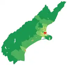
The area administered by the Canterbury Regional Council consists of all the river catchments on the east coast of the South Island from that of the Clarence River, north of Kaikoura, to that of the Waitaki River, in South Canterbury. It is New Zealand's largest region by area, with an area of 45,346 km2.
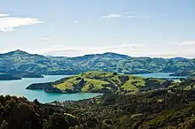
Canterbury was traditionally bounded in the north by the Conway River, to the west by the Southern Alps, and to the south by the Waitaki River. The area is commonly divided into North Canterbury (north of the Rakaia River to the Conway River), Mid Canterbury (from the Rakaia River to the Rangitata River), South Canterbury (south of the Rangitata River to the Waitaki River) and Christchurch City.
Demographics
| Year | Pop. | ±% p.a. |
|---|---|---|
| 1991 | 438,171 | — |
| 1996 | 468,039 | +1.33% |
| 2001 | 481,431 | +0.57% |
| 2006 | 521,832 | +1.62% |
| 2013 | 539,433 | +0.48% |
| 2018 | 599,694 | +2.14% |
| Source: [23][24] | ||
Statistics New Zealand estimates the population of Canterbury is 645,900 as of June 2020. The region is home to 12.7% of New Zealand's population.[1]
Canterbury Region had a population of 599,694 at the 2018 New Zealand census, an increase of 60,261 people (11.2%) since the 2013 census, and an increase of 77,862 people (14.9%) since the 2006 census. There were 225,408 households. There were 299,397 males and 300,297 females, giving a sex ratio of 1.0 males per female. Of the total population, 109,164 people (18.2%) were aged up to 15 years, 121,833 (20.3%) were 15 to 29, 272,718 (45.5%) were 30 to 64, and 95,982 (16.0%) were 65 or older. Figures may not add up to the total due to rounding.
Of those at least 15 years old, 104,658 (21.3%) people had a bachelor or higher degree, and 87,948 (17.9%) people had no formal qualifications. The median income was $33,700. The employment status of those at least 15 was that 250,845 (51.1%) people were employed full-time, 75,861 (15.5%) were part-time, and 15,864 (3.2%) were unemployed.[24]
Urban areas
Culture and identity
In the 2018 census, 82.4% were European/Pākehā, 9.4% Māori, 3.2% Pacific peoples, 11.1% Asian, and 2.6% other ethnicities. People may identify with more than one ethnicity.
The percentage of people born overseas was 23.2, compared with 27.1% nationally.
Although some people objected to giving their religion, 51.0% had no religion, 37.1% were Christian, and 5.3% had other religions.[24]
| Largest groups of overseas-born residents[25] | |
| Nationality | Population (2018) |
|---|---|
| 28,719 | |
| 13,650 | |
| 11,553 | |
| 10,428 | |
| 8,823 | |
| 6,195 | |
| 3,798 | |
| 3,672 | |
| 3,483 | |
| 3,339 | |
In the 2013 census, just under 20 percent of Canterbury's population was born overseas, compared to 25 percent for New Zealand as a whole. The British Isles remains the largest region of origin, accounting for 36.5 percent of the overseas-born population in Canterbury. Around a quarter of Canterbury's overseas-born population at the 2013 Census had been living in New Zealand for less than five years, and 11 percent had been living in New Zealand for less than two years (i.e. they moved to New Zealand after the 2011 Christchurch earthquake).[26][27]
Anglicanism is the largest Christian denomination in Canterbury with 14.8 percent affiliating, while Catholicism is the second-largest with 12.7 percent affiliating.[27]
| Ethnicity | 2006 census | 2013 census | 2018 census | |||
|---|---|---|---|---|---|---|
| Number | % | Number | % | Number | % | |
| European | 393,219 | 77.4 | 448,650 | 86.9 | 494,340 | 82.4 |
| Māori | 36,669 | 7.2 | 41,910 | 8.1 | 56,298 | 9.4 |
| Pacific peoples | 10,926 | 2.2 | 12,720 | 2.5 | 18,927 | 3.2 |
| Asian | 29,172 | 5.7 | 35,847 | 6.9 | 66,672 | 11.1 |
| Middle Eastern/Latin American/African | 3,363 | 0.7 | 4,374 | 0.8 | 7,314 | 1.2 |
| Other | 70,254 | 13.8 | 10,236 | 2.0 | 8,307 | 1.4 |
| Total people stated | 508,185 | 516,360 | 599,694 | |||
| Not elsewhere included | 13,650 | 2.6 | 23,076 | 4.3 | 0 | 0.0 |
Economy
The subnational gross domestic product (GDP) of Canterbury was estimated at NZ$37.51 billion in the year to March 2019, 12.4% of New Zealand's national GDP. The regional GDP per capita was estimated at $60,101 in the same period. In the year to March 2018, primary industries contributed $2.99 billion (8.3%) to the regional GDP, goods-producing industries contributed $8.36 billion (23.1%), service industries contributed $21.73 billion (60.0%), and taxes and duties contributed $3.10 billion (8.6%).[29]
The Canterbury region's economy is diversified into agriculture, industry, fishing, forestry, tourism and energy resources such as coal and hydroelectricity.[30] Its agriculture sector is also diversified into dairy farming, sheep farming and horticulture particularly viticulture.[31] The strength of the region's agricultural economy is displayed every November at the Canterbury A&P Show. The show coincides with the regional anniversary day and Cup Week. During the interwar period, agricultural productivity was boosted by the introduction of mechanization, lime and the improvement of seed stocks. Canterbury is also New Zealand's main producer of cereal crops such as wheat, barley and oats. As of 2002, the region produced 60.7% of the nation's supply of wheat, 51.1% of its barley stocks and 43.7% of its supply of oats.[31]
Canterbury has 25,065 hectares of horticultural land, the largest area in New Zealand. The largest crops are potatoes (4,330 ha), peas and beans (2,700 ha), wine grapes (1,770 ha), berries (1,100 ha), and onions (1,000 ha). The region produces half of the New Zealand's mushrooms, nuts and berries.[32]
The region's viticulture industry was established by French settlers in Akaroa. Since then, wine-growing is concentrated into two regions: Waipara and Burnham.[31] Recently there have been vintages from plantings from Kurow further to the south. White wine has typically predominated in Canterbury from Riesling, Sauvignon blanc, Chardonnay, Gewürztraminer, and to a lesser extent Pinot blanc and Pinot gris. Pinot noir has had some success in the province particularly in Waipara.
The manufacturing industry is the second-largest contributor to the Canterbury economy. With so many agricultural businesses, there is especially room for development and innovation in products for this sector, as well as construction and engineering as a result of the 2011 Christchurch earthquake. 2,000 local manufacturing companies employ 23,000 workers, contributing an estimated $2.2 billion NZD to the national GDP.[33]
Environment
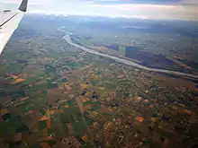
Like much of the Canterbury-Otago tussock grasslands the Canterbury Plains have been highly modified since human settlement and now support a large agricultural industry. Prior to the arrival of Māori settlers in the 13th century, much of the modern Canterbury region was covered in scrub and beech forests. Forest fires destroyed much of the original forest cover which was succeeded by tussock grassland. By the 19th century, only ten percent of this forest cover remained and the European settlers introduced several new exotic grass, lupin, pine and macrocarpa that gradually supplanted the native vegetation. Much of the native vegetation was isolated to the alpine zones and Banks Peninsula. From a minimum of about one percent of its original forest cover in circa 1900, the amount of forest on Banks Peninsula has increased.
The amount of dairy farming is increasing with a corresponding increase in demand for water. Water use is now becoming a contentious issue in Canterbury. Lowland rivers and streams are generally polluted and some of the aquifers are being overdrawn. The Central Plains Water scheme is a proposal for water storage that has attracted much controversy. The Canterbury Water Management Strategy is one of the many means being used to address the water issue.
The Canterbury mudfish (kowaro) is an endangered species that is monitored by the Department of Conservation.[34]
Government and politics
Local government
The Canterbury region is administered by the Canterbury Regional Council. The area includes ten territorial authorities, including Christchurch City Council and part of the Waitaki District, the other part of which is in Otago. Following the local government reform of 1989, Kaikoura District was part of the Nelson-Marlborough Region. That region was later abolished and replaced with three unitary authorities. Kaikoura was too small to function as an independent unitary authority and was moved under the jurisdiction of the Canterbury Regional Council in 1992. However Kaikoura remains part of Marlborough in the minds of many people. In 2006, the Banks Peninsula District was merged into Christchurch City following a 2005 referendum.
National government
The Canterbury Region is covered by ten general electorates and one Māori electorate. The city of Christchurch as a whole consists of five of these electorates, while the electorate of Waimakariri contains a mix of Christchurch and exurban Canterbury. The Port Hills, Wigram, Christchurch Central, and Christchurch East electorates are currently held by the governing Labour Party members Ruth Dyson, Megan Woods, Duncan Webb, and Poto Williams respectively. Meanwhile, the Ilam and Waimakariri electorates are currently held by members of the opposition (National Party's) Gerry Brownlee and Matthew Doocey respectively. In contrast to Christchurch, much of the surrounding Canterbury region is dominated by the National Party due to its ties to rural farming and business interests. The large Kaikōura electorate covers all of the Marlborough Region and northern Canterbury and is represented by National MP Stuart Smith. The substantial Waitaki electorate covers most of South Canterbury and neighbouring North Otago. Rangitata and Selwyn are held by National MPs Jo Goodhew and Amy Adams while Waitaki is represented by Jacqui Dean.
Under the Maori seats system, Canterbury is part of the large Te Tai Tonga electorate which covers the entire South Island, the surrounding islands and most of Wellington in the North Island. It is currently held by Labour Party MP Rino Tirikatene.
Judicially, the region is served by four District Courts at Christchurch, Ashburton, Timaru and Kaikōura, and two High Courts at Christchurch and Timaru.[35] The Christchurch High Court also hosts a divisional court of the Court of Appeal.
Transport
State Highway 1 runs the length of Canterbury, connecting north to Blenheim and the Cook Strait ferry terminal at Picton and south to Oamaru, Dunedin and Invercargill.
Christchurch International Airport, located in Harewood on the northwest outskirts of Christchurch, is the region's main airport. Regular flights operate from Christchurch to most major centres in New Zealand, as well as Australia, the Pacific Islands and eastern Asia. Timaru's Richard Pearse Airport serves South Canterbury with daily flights to Wellington.
Education
Canterbury is served by 292 primary and secondary schools educating around 94,000 students from ages 5 to 18. Around 13 percent of students attend state-integrated schools and 5 percent attend private schools, with the remaining 82 percent attending state schools.[36]
Both Christchurch and Timaru have single-sex state secondary schools.
Canterbury has two universities: the University of Canterbury located in western Christchurch, and Lincoln University located in Lincoln.
Sport
The region is home the Crusaders who play in the Super Rugby competition. The Crusaders also represent other provinces in the upper South Island but are based in Christchurch. They were formerly known as the Canterbury Crusaders.
In provincial rugby Canterbury is represented by three unions; Canterbury, Mid Canterbury and South Canterbury. For historical reasons players from Kaikoura District still play for the Marlborough Rugby Union which is part of the Tasman Provincial team (Nelson/Marlborough Unions combined).
The Canterbury Kings are Canterbury's cricket team in New Zealand's State Championship. Other sporting teams include the Mainland Tactix (netball), Canterbury United FC (football) and Canterbury Rams (basketball).
Film location
Canterbury was the location used in the filming The Lord of the Rings for the fictional city of Edoras, Rohan, on Mount Sunday, as well as Helm's deep backdrop, several miles down the valley.[37]
See also
References
- "Population estimate tables - NZ.Stat". Statistics New Zealand. Retrieved 22 October 2020.
- "Sub-national HDI - Area Database - Global Data Lab". hdi.globaldatalab.org. Retrieved 13 September 2018.
- John Parker, Frontier of Dreams: From Treaty to Nationhood (1830–1913), Auckland, NZ: Scholastic (NZ) Ltd, 2005 (ISBN 978-1-86943-681-0), pp. 58–59
- "New Zealand provinces 1848-77". rulers.org.
- Strong quake hits near Christchurch, Radio New Zealand, 4 September 2010
- "New Zealand earthquake report – Sep 4 2010 at 4:35 am (NZST)". GeoNet. Earthquake Commission and GNS Science. 4 September 2010. Archived from the original on 5 September 2010. Retrieved 6 September 2010.
- "New Zealand's South Island Rocked by Magnitude 7.0 Earthquake". Bloomberg. 3 September 2010. Retrieved 4 September 2010.
- "Latest News: Christchurch earthquake". The New Zealand Herald. 5 September 2010. Retrieved 4 September 2010.
- "Central Christchurch to be evacuated after quake". Radio New Zealand. 4 September 2010. Retrieved 4 September 2010.
- Stuff.co.nz (4 September 2010). "Officers flown into protect Christchurch". Stuff. New Zealand. Archived from the original on 21 October 2012. Retrieved 4 September 2010.
- 9:08 am Saturday 4 September 2010. "State of emergency declared after quake hits Chch | NATIONAL News". Tvnz.co.nz. Retrieved 4 September 2010.
- "Massive 7.4 quake hits South Island", Stuff, New Zealand, 4 September 2010, archived from the original on 6 September 2010
- "Canterbury shaken by 240 aftershocks". Stuff. New Zealand. 8 September 2010. Retrieved 8 September 2010.
- "Multiple fatalities in New Zealand earthquake near Christchurch". Daily Telegraph. UK. 22 February 2011. Retrieved 22 February 2011.
- "New Zealand Earthquake Report – Feb 22, 2011 at 12:51 pm (NZDT)". GeoNet. Earthquake Commission and GNS Science. 22 February 2011. Archived from the original on 23 February 2011. Retrieved 22 February 2011.
- Fox, Andrea (1 March 2011). "Building code no match for earthquake". The Dominion Post. Retrieved 11 July 2011.
- "List of deceased". New Zealand Police. 1 June 2011. Retrieved 11 July 2011.
- "Archived copy". Archived from the original on 19 September 2012. Retrieved 21 August 2011.CS1 maint: archived copy as title (link) Christchurch aftershocks: Hard-hit east residents three times unlucky
- "Christchurch earthquake: Latest information - Friday". Stuff. 4 March 2011. Retrieved 3 October 2011.
- "'Thousands of homes need to go'". The Press. 14 June 2011. Retrieved 3 October 2011.
- Iconic cathedral window collapses in quake
- Anglican Taonga: Cathedral loses rose window
- "2001 Census: Regional summary". archive.stats.govt.nz. Retrieved 28 April 2020.
- "Statistical area 1 dataset for 2018 Census". Statistics New Zealand. March 2020. Canterbury Region (13). 2018 Census place summary: Canterbury Region
- "Birthplace (detailed), for the census usually resident population count, 2006, 2013, and 2018 Censuses (RC, TA, SA2, DHB)". nzdotstat.stats.govt.nz. Retrieved 28 February 2020.
- "Birthplace (detailed), for the census usually resident population count, 2001, 2006, and 2013 (RC, TA) – NZ.Stat". Statistics New Zealand. Retrieved 23 January 2016.
- "2013 Census QuickStats about culture and identity – data tables". Statistics New Zealand. 15 April 2014. Archived from the original on 24 May 2014. Retrieved 25 January 2016.
- "Ethnic group (detailed total response - level 3) by age and sex, for the census usually resident population count, 2006, 2013, and 2018 Censuses (RC, TA, SA2, DHB)". nzdotstat.stats.govt.nz. Retrieved 3 March 2020.
- "Regional gross domestic product: Year ended March 2019 | Stats NZ". www.stats.govt.nz. Retrieved 21 May 2020.
- Wilson, John (2 March 2009). "Canterbury region: Industry". Te Ara: The Encyclopedia of New Zealand. Retrieved 11 June 2010.
- Wilson, John (2 March 2009). "Canterbury region: Agriculture after 1900". Te Ara: The Encyclopedia of New Zealand. Retrieved 11 June 2010.
- "Fresh Facts: New Zealand Horticulture" (PDF). Plant & Food Research. 2018. ISSN 1177-2190.
- "Christchurch Manufacturing Jobs". CDC.org.nz. Retrieved 9 March 2015.
- "Mudfish: New Zealand Freshwater Fish". www.doc.govt.nz. Department of Conservation. Retrieved 22 February 2019.
- "Contact a court — Courts of New Zealand". www.courtsofnz.govt.nz. Retrieved 27 June 2019.
- "New Zealand Schools Directory". New Zealand Ministry of Education. Retrieved 26 April 2020.
- (DOC), corporatename = New Zealand Department of Conservation. "Lord of the Rings locations". www.doc.govt.nz.
External links
| Wikivoyage has a travel guide for Canterbury (New Zealand). |
| Wikimedia Commons has media related to Canterbury Region. |
- Environment Canterbury (Canterbury Regional Council)
- Canterbury Biodiversity, Environment Canterbury
| North Island | ||
|---|---|---|
| South Island | ||
* Governed by a unitary authority rather than a regional council | ||
| Authority control |
|---|