Minnesota State Highway 222
Minnesota State Highway 222 (MN 222) is a short 1.474-mile-long (2.372 km) highway in northwest Minnesota, which runs from its intersection with State Highway 92 in Lambert Township of Red Lake County and continues north to its northern terminus at its intersection with Red Lake County State-Aid Highway 5 in Oklee. The route is 1.5 miles (2.4 km) in length.
| ||||
|---|---|---|---|---|
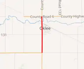
MN 222 highlighted in red | ||||
| Route information | ||||
| Defined by MS § 161.115(153) | ||||
| Maintained by MnDOT | ||||
| Length | 1.474 mi[1] (2.372 km) | |||
| Existed | July 1, 1949[2]–present | |||
| Major junctions | ||||
| South end | ||||
| North end | ||||
| Location | ||||
| Counties | Red Lake | |||
| Highway system | ||||
| ||||

Route description
Highway 222 serves as a short north–south connector route in northwest Minnesota. It connects State Highway 92 with the town of Oklee.
The route is legally defined as Route 222 in the Minnesota Statutes.[3]
History
Highway 222 was authorized on July 1, 1949.[2]
The route was paved at the time it was marked.[4]
The 2019 Minnesota Legislature authorized removal of the highway, pending a turnback agreement with Red Lake County.[5]
Major intersections
The entire route is in Red Lake County.
| Location | mi[1] | km | Destinations | Notes | |
|---|---|---|---|---|---|
| Lambert Township | 0.000 | 0.000 | Southern terminus; roadway continues south as MN 92 | ||
| Oklee | 1.008 | 1.622 | |||
| 1.403 | 2.258 | ||||
| 1.474 | 2.372 | Northern terminus; roadway continues north as CSAH 5 | |||
| 1.000 mi = 1.609 km; 1.000 km = 0.621 mi | |||||
References
- "Trunk Highway Log Point Listing — Construction District 2" (PDF). Minnesota Department of Transportation. August 23, 2010. Archived from the original (PDF) on December 4, 2008. Retrieved December 12, 2010.
- "Chapter 663-H.F. No. 1792", Session Laws of Minnesota for 1949, Earl L. Berg, Commissioner of Administration, pp. 1177–1185
- "161.115, Additional Trunk Highways". Minnesota Statutes. Office of the Revisor of Statutes, State of Minnesota. 2010. Retrieved December 12, 2010.
- Minnesota 1950 Official Highway Map (Map). Minnesota Department of Highways. January 1, 1950. § D6. Archived from the original on July 21, 2011. Retrieved April 5, 2020.
- "Chapter 3-H.F.No. 6, §132", Minnesota Session Laws - 2019, 1st Special Session, Office of the Revisor of Statutes, State of Minnesota, May 30, 2019, retrieved November 11, 2020