Minnesota State Highway 223
Minnesota State Highway 223 (MN 223) is a 7.643-mile-long (12.300 km) highway in northwest Minnesota, which runs from its intersection with State Highway 92 in Holst Township of Clearwater County and continues east to its eastern terminus at its intersection with Clearwater County State-Aid Highway 10 in Leonard. It is also signed as Leonard Road.
| ||||
|---|---|---|---|---|
| Leonard Road | ||||
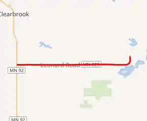
MN 223 highlighted in red | ||||
| Route information | ||||
| Defined by MS § 161.115(154) | ||||
| Maintained by MnDOT | ||||
| Length | 7.643 mi[1] (12.300 km) | |||
| Existed | July 1, 1949[2]–present | |||
| Major junctions | ||||
| West end | ||||
| East end | ||||
| Location | ||||
| Counties | Clearwater | |||
| Highway system | ||||
| ||||

MN 223 passes through Holst Township, Dudley Township, and Leonard.
Route description
Highway 223 serves as an east–west connector route in northwest Minnesota. It connects State Highway 92 with the town of Leonard.
The route is legally defined as Route 223 in the Minnesota Statutes.[3]
Major intersections
The entire route is in Clearwater County.
| Location | mi[1] | km | Destinations | Notes | |
|---|---|---|---|---|---|
| Holst Township | 0.000 | 0.000 | Western terminus | ||
| 1.980 | 3.187 | ||||
| 3.239 | 5.213 | ||||
| 3.989 | 6.420 | ||||
| Dudley Township | 6.960 | 11.201 | |||
| Leonard | 7.520 | 12.102 | |||
| 7.591 | 12.217 | ||||
| 7.644 | 12.302 | Eastern terminus | |||
| 1.000 mi = 1.609 km; 1.000 km = 0.621 mi | |||||
References
- "Trunk Highway Log Point Listing - Construction District 2" (PDF). Minnesota Department of Transportation. August 23, 2010. Archived from the original (PDF) on December 4, 2008. Retrieved December 12, 2010.
- "Chapter 663-H.F. No. 1792", Session Laws of Minnesota for 1949, Earl L. Berg, Commissioner of Administration, pp. 1177–1185
- "161.115, Additional Trunk Highways". Minnesota Statutes. Office of the Revisor of Statutes, State of Minnesota. 2010. Retrieved December 12, 2010.
- 1960 Official Road Map - Minnesota (Map). Cartography by The H.M. Gousha Company. Minnesota Department of Highways. 1960. § E6. Archived from the original on August 25, 2011. Retrieved December 12, 2010.
- 1961 Official Road Map - Minnesota (Map). Cartography by The H.M. Gousha Company. Minnesota Department of Highways. 1961. § E6. Archived from the original on 2011-08-25. Retrieved 2020-04-05.
External links
This article is issued from Wikipedia. The text is licensed under Creative Commons - Attribution - Sharealike. Additional terms may apply for the media files.
