Minnesota State Highway 39
Minnesota State Highway 39 (MN 39) is a short 1.080-mile-long (1.738 km) highway in northeast Minnesota, which runs from its intersection with State Highway 23 (Commonwealth Avenue) in Duluth and continues east to its eastern terminus at the Wisconsin state line (at the Oliver Bridge), where it becomes Wisconsin Highway 105 upon entering the village of Oliver, Wisconsin.
| ||||
|---|---|---|---|---|
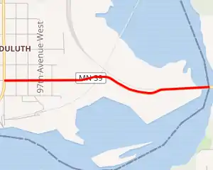
MN 39 highlighted in red | ||||
| Route information | ||||
| Defined by MS § 161.115(144) | ||||
| Maintained by MnDOT | ||||
| Length | 1.080 mi[1] (1.738 km) | |||
| Existed | April 12, 1943[2]–present | |||
| Major junctions | ||||
| West end | ||||
| East end | the Minnesota — Wisconsin state line | |||
| Location | ||||
| Counties | St. Louis | |||
| Highway system | ||||
| ||||

The east end of Highway 39 crosses the Saint Louis River to Wisconsin, over the double-deck Oliver Bridge with a railroad track on the upper deck.
Highway 39 is also known as McCuen Street in the Gary–New Duluth neighborhood of Duluth.
Route description
State Highway 39 serves as a short route between Duluth and the village of Oliver, Wisconsin.
Highway 39, together with Wisconsin Highway 105, are part of a 6-mile (9.7 km) east–west connector between the city of Superior, WI, Oliver, and the Gary–New Duluth neighborhood of Duluth.
The route is legally defined as Legislative Route 213 in the Minnesota Statutes.[3] It is not marked with this number.
History
Highway 39 was authorized on April 12, 1943.[2]
From 1958 to 1973, Highway 39 had continued farther west, extending over present-day State Highway 210 through Jay Cooke State Park to then-U.S. Highway 61 (now State Highway 45) at Carlton.[4]
The road deck on the Highway 39 / Highway 105 Oliver Bridge was originally a wooden deck. Modernization came in the year 2000 when both states' DOT (WisDOT and MnDOT) cooperated with the Duluth, Missabe and Iron Range Railway to jointly fund a reconstruction of the roadway surface, which now features a stronger steel and reinforced concrete deck.
Major intersections
The entire route is in St. Louis County.
| Location | mi[1] | km | Destinations | Notes | |
|---|---|---|---|---|---|
| Duluth | 0.000 | 0.000 | Western terminus | ||
| Saint Louis River | 0.901 | 1.450 | Oliver Bridge; Minnesota–Wisconsin state line | ||
| Oliver | 1.080 | 1.738 | Eastern terminus | ||
| 1.000 mi = 1.609 km; 1.000 km = 0.621 mi | |||||
References
- "Trunk Highway Log Point Listing - Construction District 1" (PDF). Minnesota Department of Transportation. August 20, 2010. Archived from the original (PDF) on December 4, 2008. Retrieved October 19, 2010.
- "Chapter 399-H.F. No. 1000", Session Laws of Minnesota for 1943, Commissioner of Administration, pp. 536–537
- "161.115, Additional Trunk Highways". Minnesota Statutes. Office of the Revisor of Statutes, State of Minnesota. 2010. Retrieved October 18, 2010.
- Riner, Steve. "Details of Routes 26-50". The Unofficial Minnesota Highways Page. Retrieved February 24, 2007.