Minnesota State Highway 38
Minnesota State Highway 38 (MN 38) is a 46.766-mile-long (75.263 km) highway in north-central Minnesota, which runs from its intersection with U.S. Highway 2 in Grand Rapids and continues north to its northern terminus at its intersection with State Highway 1 in Effie.
| ||||
|---|---|---|---|---|
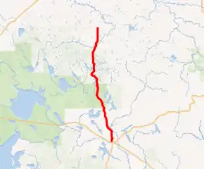
MN 38 highlighted in red | ||||
| Route information | ||||
| Maintained by MnDOT | ||||
| Length | 46.766 mi[1] (75.263 km) | |||
| Existed | 1933[2]–present | |||
| Tourist routes | ||||
| Major junctions | ||||
| South end | ||||
| North end | ||||
| Location | ||||
| Counties | Itasca | |||
| Highway system | ||||
| ||||

The entire length of Highway 38 has been designated a National Scenic Byway under the name Edge of the Wilderness.[3] It is also sometimes called the Northwoods Highway.
Route description
State Highway 38 serves as a north–south route between Grand Rapids and Effie in north-central Minnesota. The route is noted for being a twisty roadway.
The route passes through many lake resort areas, such as Wabana Lake, Trout Lake, and others.
Highway 38 passes through the Chippewa National Forest between Itasca County Road 19 and Bigfork.[4]
Scenic State Park is located 7 miles east of the junction of Highway 38 and County Road 7 at Bigfork. The park entrance is located on County Road 7.[5]
Highway 38 parallels State Highway 6 throughout its route.
Major intersections
The entire route is in Itasca County.
| Location | mi[1] | km | Destinations | Notes | |
|---|---|---|---|---|---|
| Grand Rapids | 0.000 | 0.000 | |||
| Grand Rapids Township | 3.427 | 5.515 | |||
| Arbo Township | 6.476 | 10.422 | CR 49 (Wabana Road) | ||
| Deer Lake | 12.584 | 20.252 | CR 60 | ||
| 12.894 | 20.751 | CR 19 | |||
| 22.314 | 35.911 | CR 48 | |||
| 23.590 | 37.964 | CR 49 | |||
| Marcell | 28.493 | 45.855 | |||
| Marcell Township | 28.966 | 46.616 | CR 45 | ||
| Stokes Township | 32.943 | 53.017 | CR 43 | ||
| Bigfork | 39.800 | 64.052 | CR 7 (Cemetery Road) | ||
| 40.725 | 65.541 | CR 14 | |||
| Bigfork Township | 42.141 | 67.819 | CR 42 | ||
| Effie | 46.858 | 75.411 | |||
| 1.000 mi = 1.609 km; 1.000 km = 0.621 mi | |||||
References
- "Trunk Highway Log Point Listing - Construction District 1" (PDF). Minnesota Department of Transportation. August 20, 2010. Archived from the original (PDF) on December 4, 2008. Retrieved October 17, 2010.
- Riner, Steve. "Details of Routes 26-50". The Unofficial Minnesota Highways Page. Retrieved February 24, 2007.
- "Edge of the Wilderness". National Scenic Byway Program. U.S. Department of Transportation Federal Highway Administration. Retrieved October 17, 2010.
- Chippewa National Forest website - Link
- Minnesota DNR website for Scenic State Park - Link