Minnesota State Highway 67
Minnesota State Highway 67 (MN 67) is a 83.026-mile-long (133.617 km) highway in southwest Minnesota, which runs from its intersection with U.S. Highway 75 in Oshkosh Township near Canby and continues east and southeast to its eastern terminus at its intersection with State Highway 68 in Morgan.
| ||||
|---|---|---|---|---|
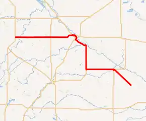
MN 67 highlighted in red | ||||
| Route information | ||||
| Maintained by MnDOT | ||||
| Length | 83.026 mi (133.617 km) | |||
| Existed | 1933–present | |||
| Major junctions | ||||
| West end | ||||
| ||||
| East end | ||||
| Location | ||||
| Counties | Yellow Medicine, Redwood | |||
| Highway system | ||||
| ||||

Route description
Highway 67 serves as an east–west and north–south route in southwest Minnesota between Canby, Clarkfield, Granite Falls, Redwood Falls, and Morgan.
The highway is officially marked as an east–west route by its highway shields from beginning to end.
Upper Sioux Agency State Park is located on Highway 67, eight miles southeast of Granite Falls.[1]
Highway 67 runs together with State Highway 19 for 14 miles (23 km), west of Redwood Falls.
History
| |
|---|---|
| Location | Redwood Falls to Morgan |
| Length | 13 mi (21 km) |
| Existed | 1934–1963 |
Highway 67 was authorized in 1920 from present-day Highway 19 south of Echo to Granite Falls.[2] In 1934, it was extended westward to U.S. 75 at Canby. The route was expanded east to Redwood Falls and southeast to Morgan circa 1963.[3]
Highway 67 was paved from Granite Falls to U.S. Highway 75 by 1940. The route was completely paved by 1953.[3]
Major intersections
| County | Location | mi | km | Destinations | Notes |
|---|---|---|---|---|---|
| Yellow Medicine | Oshkosh Township | 0.000 | 0.000 | Western terminus | |
| Clarkfield | 19.039 | 30.640 | |||
| Stony Run Township | 31.259 | 50.306 | Northern end of US 212 concurrency | ||
| Granite Falls | 32.358 | 52.075 | Eastern end of US 212 concurrency; northern end of MN 23 concurrency | ||
| 32.571 | 52.418 | Southern end of MN 23 concurrency | |||
| Echo Township | 54.802 | 88.195 | Western end of MN 19 concurrency | ||
| Redwood | Redwood Falls | 69.761 | 112.269 | Eastern end of MN 19 concurrency; northern end of US 71 concurrency | |
| 70.216 | 113.002 | Southern end of US 71 concurrency | |||
| Morgan | 82.942 | 133.482 | Eastern terminus; roadway continues as MN 68 | ||
1.000 mi = 1.609 km; 1.000 km = 0.621 mi
| |||||
References
- Minnesota DNR web page for Upper Sioux Agency State Park - Link
- Minnesota State Legislature (2010). "§ 161.114, Constitutional Trunk Highways". Minnesota Statutes. Minnesota Office of the Revisor of Statutes. Retrieved October 25, 2010.
- Riner, Steve. "Details of routes 51–75". The Unofficial Minnesota Highways Page. Self-published. Retrieved October 25, 2010.