Minnesota State Highway 98
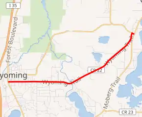
Minnesota State Highway 98 was a highway in Minnesota, which ran from to U.S. Route 61 in Wyoming to U.S. Route 8 in Chisago City. It was decommissioned in 1996 and became Chisago County Road 22.
| ||||
|---|---|---|---|---|

MN 98 highlighted in red | ||||
| Route information | ||||
| Defined by MS § 161.114() | ||||
| Maintained by MnDOT | ||||
| Length | 5 mi[1] (8 km) | |||
| Existed | 1933, 1955[2]–1996[3] | |||
| Major junctions | ||||
| West end | ||||
| East end | ||||
| Location | ||||
| Counties | Chisago | |||
| Highway system | ||||
| ||||
Highway 98 was also known as Wyoming Trail.
Route description
Highway 98 served to connect U.S. 61 in the city of Wyoming with U.S. 8 in Chisago City. Legally, it followed Minnesota Constitutional Route 46 as defined in the Minnesota Statutes § 161.114.
History
As commissioned in 1933, Highway 98 ran south from Chisago City along what is now County Road 24 between Chisago and Green lakes. It then moved westward along today's County Road 23 and U.S. 8 to Forest Lake. In the mid-1950s, the route was realigned west of Green Lake, and U.S. 8 was moved to this segment, and MN 98 was moved to the former route of 8. Legally, the original route is defined as Route 98 in the Minnesota Statutes § 161.115(29).
Highway 98 was turned back in 1996 and became Chisago County Road 22.
Major intersections
The entire route is in Chisago County.
| Location | mi[4][1] | km | Destinations | Notes | |
|---|---|---|---|---|---|
| Wyoming | 0 | 0.0 | Western terminus | ||
| 1 | 1.6 | Goodview Avenue | |||
| 2 | 3.2 | Pioneer Road | |||
| Chisago City | 5 | 8.0 | Eastern terminus | ||
| 1.000 mi = 1.609 km; 1.000 km = 0.621 mi | |||||
References
- 1995-1996 Official Highway Map - Minnesota (Map). Minnesota Department of Transportation. 1995. § K15. Archived from the original on April 15, 2013.
- Riner, Steve. "Details of Routes 76-100". The Unofficial Minnesota Highways Page. Retrieved October 15, 2006.
- "2010 Control Section Report" (PDF). Minnesota Department of Transportation. August 31, 2010. Archived from the original (PDF) on March 24, 2009. Retrieved December 15, 2010.
|section=ignored (help) - General Highway Map - Chisago County, Minnesota (PDF) (Map). Minnesota Department of Transportation. 2010. Archived from the original (PDF) on September 8, 2012.
