Chisago County, Minnesota
Chisago County (/ʃɪˈsɑːɡoʊ/ shi-SAH-goh) is a county in the U.S. state of Minnesota. As of the 2010 United States Census, the population was 53,887.[2] Its county seat is Center City.[3]
Chisago County | |
|---|---|
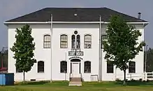 Old Chisago County Courthouse originally in Center City, Minnesota. In 1990 moved to Almelund, Minnesota. | |
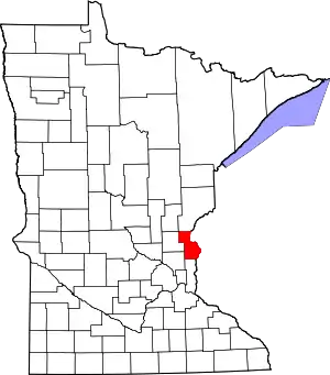 Location within the U.S. state of Minnesota | |
 Minnesota's location within the U.S. | |
| Coordinates: 45°30′N 92°55′W | |
| Country | |
| State | |
| Founded | September 1, 1851[1] |
| Named for | Chisago Lake |
| Seat | Center City |
| Largest city | North Branch |
| Area | |
| • Total | 442 sq mi (1,140 km2) |
| • Land | 415 sq mi (1,070 km2) |
| • Water | 28 sq mi (70 km2) 6.2%% |
| Population (2010) | |
| • Total | 53,887 |
| • Estimate (2019) | 56,579 |
| • Density | 133/sq mi (51/km2) |
| Time zone | UTC−6 (Central) |
| • Summer (DST) | UTC−5 (CDT) |
| Congressional district | 8th |
| Website | www |
Chisago County is part of the Minneapolis-St. Paul-Bloomington, MN-WI Metropolitan Statistical Area.
History
Chisago County was organized in 1851. It took its name from Chisago Lake.[4] Swedish immigrants were the predominant group in Chisago Country from the early to late 1800's, and strongly influenced the county's religious and cultural development. The county has retained and continues to celebrate much of its Swedish heritage.[5]
Geography
Chisago County lies on Minnesota's eastern border, abutting the western border of Wisconsin (across the Saint Croix River). The Saint Croix flows south-southeast along the county's eastern border. The Sunrise River flows north through the county's central part, collecting the waters of the North Branch Sunrise River and Hay Creek before discharging into the St. Croix at the county's eastern boundary. The county terrain consists of rolling hills, devoted to agriculture.[7] The terrain slopes to the south and east, with its highest point near the northwest corner, at 1,017' (310m) ASL.[8] The county has an area of 442 square miles (1,140 km2), of which 415 square miles (1,070 km2) is land and 28 square miles (73 km2) (6.2%) is water.[9]
Major highways
 Interstate 35
 US Highway 8
 US Highway 61
 Minnesota State Highway 95
 Minnesota State Highway 243
- List of county roads
Adjacent counties
- Pine County - north
- Burnett County, Wisconsin - northeast
- Polk County, Wisconsin - east
- Washington County - south
- Anoka County - southwest
- Isanti County - west
- Kanabec County - northwest
Protected areas[7]
- Fish Lake County Park
- Franconia Bluffs Scientific and Natural Area
- Interstate State Park
- Lawrence Creek Scientific and Natural Area
- Ojiketa Regional Park
- Saint Croix National Scenic Riverway (part)
- Wild River State Park
Climate and weather
| Center City, Minnesota | ||||||||||||||||||||||||||||||||||||||||||||||||||||||||||||
|---|---|---|---|---|---|---|---|---|---|---|---|---|---|---|---|---|---|---|---|---|---|---|---|---|---|---|---|---|---|---|---|---|---|---|---|---|---|---|---|---|---|---|---|---|---|---|---|---|---|---|---|---|---|---|---|---|---|---|---|---|
| Climate chart (explanation) | ||||||||||||||||||||||||||||||||||||||||||||||||||||||||||||
| ||||||||||||||||||||||||||||||||||||||||||||||||||||||||||||
| ||||||||||||||||||||||||||||||||||||||||||||||||||||||||||||
In recent years, average temperatures in Center City have ranged from a low of 2 °F (−17 °C) in January to a high of 84 °F (29 °C) in July, although a record low of −38 °F (−39 °C) was recorded in January 1977 and a record high of 104 °F (40 °C) was recorded in July 1988. Average monthly precipitation ranged from 0.89 inches (23 mm) in January to 4.48 inches (114 mm) in June.[10]
Demographics
| Historical population | |||
|---|---|---|---|
| Census | Pop. | %± | |
| 1860 | 1,743 | — | |
| 1870 | 4,358 | 150.0% | |
| 1880 | 7,982 | 83.2% | |
| 1890 | 10,359 | 29.8% | |
| 1900 | 13,248 | 27.9% | |
| 1910 | 13,537 | 2.2% | |
| 1920 | 14,445 | 6.7% | |
| 1930 | 13,189 | −8.7% | |
| 1940 | 13,124 | −0.5% | |
| 1950 | 12,669 | −3.5% | |
| 1960 | 13,419 | 5.9% | |
| 1970 | 17,492 | 30.4% | |
| 1980 | 25,717 | 47.0% | |
| 1990 | 30,521 | 18.7% | |
| 2000 | 41,101 | 34.7% | |
| 2010 | 53,887 | 31.1% | |
| 2019 (est.) | 56,579 | [11] | 5.0% |
| US Decennial Census[12] 1790-1960[13] 1900-1990[14] 1990-2000[15] 2010-2019[2] | |||
2010 census
As of the 2010 United States Census, there were 53,887 people, 19,470 households, and 14,389 families in the county. The population density was 130/sqmi (50.1/km2). There were 21,172 housing units at an average density of 51.0/sqmi (19.7/km2). The racial makeup of the county was 95.80% White, 1.20% Black or African American, 0.60% Native American, 0.90% Asian, 0.01% Pacific Islander, 0.30% from other races, and 1.20% from two or more races. 1.50% of the population were Hispanic or Latino of any race.
There were 19,470 households, out of which 37.20% had children under the age of 18 living with them, 61.00% were married couples living together, 7.90% had a female householder with no husband present, and 26.10% were non-families. 20.30% of all households were made up of individuals, and 8.60% had someone living alone who was 65 years of age or older. The average household size was 2.68 and the average family size was 3.09.
The county population contained 25.70% under the age of 18, 7.30% from 18 to 24, 26.80% from 25 to 44, 28.60% from 45 to 64, and 11.60% who were 65 years of age or older. The median age was 39 years. For every 100 females there were 101.60 males. For every 100 females age 18 and over, there were 101.50 males. The per capita income for the county was $29,293. About 6.20% of the population was below the poverty line.
2000 census
As of the 2000 census, there were 41,101 people, 14,454 households, and 11,086 families in the county. The population density was 99.0/sqmi (38.2/km2). There were 15,533 housing units at an average density of 37 per square mile (14/km2). The racial makeup of the county was 97.21% White, 0.51% Black or African American, 0.45% Native American, 0.70% Asian, 0.03% Pacific Islander, 0.31% from other races, and 0.80% from two or more races. 1.15% of the population were Hispanic or Latino of any race. 31.3% were of German, 18.1% Swedish, 11.3% Norwegian and 6.9% Irish ancestry.
There were 14,454 households, out of which 41.00% had children under the age of 18 living with them, 64.50% were married couples living together, 8.00% had a female householder with no husband present, and 23.30% were non-families. 18.40% of all households were made up of individuals, and 7.40% had someone living alone who was 65 years of age or older. The average household size was 2.79 and the average family size was 3.18.
The county population contained 30.20% under the age of 18, 7.10% from 18 to 24, 32.20% from 25 to 44, 20.70% from 45 to 64, and 9.80% who were 65 years of age or older. The median age was 34 years. For every 100 females there were 103.90 males. For every 100 females age 18 and over, there were 101.70 males.
The median income for a household in the county was $52,012, and the median income for a family was $57,335. Males had a median income of $40,743 versus $27,653 for females. The per capita income for the county was $21,013. About 3.20% of families and 5.10% of the population were below the poverty line, including 5.40% of those under age 18 and 8.00% of those age 65 or over.
Education
- Chisago Lakes High School
- North Branch Area High School
- Rush City High School
Communities
Cities
- Center City (county seat)
- Chisago City
- Harris
- Lindström
- North Branch
- Rush City
- Shafer
- Stacy
- Taylors Falls
- Wyoming
Townships
Arts and culture
Chisago County is strongly influenced by the German, Swedish and Norwegian immigrants who settled there in the mid-19th century. It provided the setting for much of Swedish author Vilhelm Moberg's suite of novels The Emigrants in the 1950s, and Moberg engaged in both archival and oral history research for his books to recreate the early Swedish immigration in the area. Sculptor Ian Dudley's bronze statue of Moberg stands in Chisago City's park. His fictional characters Karl-Oskar and Kristina Nilsson from Ljuder parish in Småland settled around the Lake Ki-Chi-Saga (from the Ojibwe language Ki-chi-saga-igun (Gichi-zaaga'igan in the contemporary spelling) meaning "Big Lake-with-an-outlet," which was later shortened to Lake Chisago). The early settlers' heritage is still honored by the annual Karl Oskar Days in Lindström.
Government and politics
Chisago Country has trended conservative in recent state and federal elections, backing every Republican candidate for president since 2000.
| Year | Republican | Democratic | Third parties |
|---|---|---|---|
| 2020 | 63.4% 21,916 | 34.2% 11,806 | 2.5% 848 |
| 2016 | 61.0% 18,441 | 30.7% 9,278 | 8.3% 2,509 |
| 2012 | 55.1% 16,227 | 42.5% 12,524 | 2.3% 690 |
| 2008 | 53.9% 15,789 | 43.6% 12,783 | 2.5% 733 |
| 2004 | 55.6% 15,705 | 43.2% 12,219 | 1.2% 336 |
| 2000 | 49.7% 10,937 | 43.6% 9,593 | 6.6% 1,457 |
| 1996 | 33.7% 5,984 | 48.6% 8,611 | 17.7% 3,138 |
| 1992 | 28.1% 4,813 | 41.3% 7,077 | 30.6% 5,229 |
| 1988 | 43.5% 6,163 | 55.6% 7,875 | 0.9% 132 |
| 1984 | 48.1% 6,279 | 51.2% 6,683 | 0.7% 87 |
| 1980 | 40.1% 5,017 | 49.8% 6,240 | 10.1% 1,266 |
| 1976 | 35.7% 3,874 | 61.0% 6,625 | 3.4% 368 |
| 1972 | 51.1% 4,718 | 45.2% 4,174 | 3.8% 349 |
| 1968 | 39.9% 3,053 | 53.6% 4,102 | 6.5% 496 |
| 1964 | 36.7% 2,525 | 63.1% 4,347 | 0.3% 17 |
| 1960 | 56.6% 3,822 | 43.0% 2,907 | 0.4% 25 |
| 1956 | 55.5% 3,413 | 44.4% 2,731 | 0.2% 9 |
| 1952 | 60.3% 3,892 | 39.3% 2,536 | 0.5% 32 |
| 1948 | 44.6% 2,704 | 52.5% 3,184 | 2.9% 177 |
| 1944 | 55.6% 3,020 | 43.7% 2,376 | 0.7% 38 |
| 1940 | 56.0% 3,569 | 43.1% 2,746 | 1.0% 62 |
| 1936 | 40.5% 2,462 | 55.3% 3,360 | 4.2% 258 |
| 1932 | 43.9% 2,524 | 53.0% 3,047 | 3.2% 184 |
| 1928 | 75.5% 4,215 | 23.2% 1,297 | 1.3% 70 |
| 1924 | 52.8% 2,678 | 2.7% 135 | 44.5% 2,259 |
| 1920 | 80.0% 4,361 | 8.9% 484 | 11.1% 605 |
| 1916 | 61.2% 1,749 | 33.0% 944 | 5.7% 164 |
| 1912 | 13.3% 346 | 16.7% 435 | 70.0% 1,819 |
| 1908 | 79.9% 2,107 | 15.5% 408 | 4.6% 122 |
| 1904 | 91.5% 2,417 | 5.9% 156 | 2.7% 70 |
| 1900 | 83.4% 2,354 | 14.6% 411 | 2.1% 59 |
| 1896 | 84.4% 2,558 | 14.4% 437 | 1.2% 37 |
| 1892 | 75.0% 1,480 | 17.1% 338 | 7.9% 155 |
| Position | Name | District | Next Election | |
|---|---|---|---|---|
| Commissioner and Vice Chair | Chris DuBose | District 1 | 2022 | |
| Commissioner | Rick Greene | District 2 | 2020 | |
| Commissioner | George McMahon | District 3 | 2020 | |
| Commissioner and Chair | Ben Montzka | District 4 | 2022 | |
| Commissioner | Mike Robinson | District 5 | 2020 | |
| Position | Name | Affiliation | District | |
|---|---|---|---|---|
| Senate | Mark Koran[18] | Republican | District 32 | |
| Senate | Karin Housley[19] | Republican | District 39 | |
| House of Representatives | Brian Johnson[20] | Republican | District 32A | |
| House of Representatives | Anne Neu[21] | Republican | District 32B | |
| House of Representatives | Bob Dettmer[22] | Republican | District 39A | |
| Position | Name | Affiliation | District | |
|---|---|---|---|---|
| House of Representatives | Pete Stauber | Republican | 8th | |
| Senate | Amy Klobuchar[23] | Democrat | N/A | |
| Senate | Tina Smith[24] | Democrat | N/A | |
See also
References
- "Minnesota Place Names". Minnesota Historical Society. Archived from the original on June 20, 2012. Retrieved March 17, 2014.
- "State & County QuickFacts". United States Census Bureau. Archived from the original on July 8, 2011. Retrieved August 31, 2013.
- "Find a County". National Association of Counties. Archived from the original on May 3, 2015. Retrieved June 7, 2011.
- Upham, Warren (1920). Minnesota Geographic Names: Their Origin and Historic Significance. Minnesota Historical Society. p. 107.
- Bosman, Julie (April 16, 2015). "Lindström Loses Umlauts on Road Signs, and the Town is Dotted With Displeasure (Published 2015)". The New York Times. ISSN 0362-4331. Retrieved December 25, 2020.
- Nelson, Steven (2011). Savanna Soils of Minnesota. Minnesota: Self. pp. 61-64. ISBN 978-0-615-50320-2.
- Chisago County MN Google Maps (accessed 6 March 2019)
- ""Find an Altitude/Chisago County MN" Google Maps (accessed 6 March 2019)". Archived from the original on May 21, 2019. Retrieved March 6, 2019.
- "2010 Census Gazetteer Files". US Census Bureau. August 22, 2012. Archived from the original on October 6, 2014. Retrieved October 6, 2014.
- "Monthly Averages for Center City MN". The Weather Channel. Retrieved November 6, 2011.
- "Population and Housing Unit Estimates". Retrieved March 26, 2020.
- "US Decennial Census". US Census Bureau. Archived from the original on April 26, 2015. Retrieved October 6, 2014.
- "Historical Census Browser". University of Virginia Library. Retrieved October 6, 2014.
- "Population of Counties by Decennial Census: 1900 to 1990". US Census Bureau. Retrieved October 6, 2014.
- "Census 2000 PHC-T-4. Ranking Tables for Counties: 1990 and 2000" (PDF). US Census Bureau. Retrieved October 6, 2014.
- Leip, David. "Atlas of US Presidential Elections". uselectionatlas.org. Retrieved April 17, 2018.
- "County Board of Commissioners | Chisago County, MN - Official Website". www.chisagocounty.us. Retrieved June 26, 2020.
- "MN State Senate". www.senate.mn. Retrieved June 26, 2020.
- "MN State Senate". www.senate.mn. Retrieved June 26, 2020.
- "Rep. Brian Johnson (32A) - Minnesota House of Representatives". www.house.leg.state.mn.us. Retrieved June 26, 2020.
- "Rep. Anne Neu (32B) - Minnesota House of Representatives". www.house.leg.state.mn.us. Retrieved June 26, 2020.
- "Rep. Bob Dettmer (39A) - Minnesota House of Representatives". www.house.leg.state.mn.us. Retrieved June 26, 2020.
- "U.S. Senator Amy Klobuchar". www.klobuchar.senate.gov. Retrieved June 24, 2020.
- "Home". Senator Tina Smith. Retrieved June 24, 2020.
External links
- Chisago County government's website
- Chisago County Historical Society website
- Minnesota DOT Highway map of Chisago County
Places adjacent to Chisago County, Minnesota | ||||||||||
|---|---|---|---|---|---|---|---|---|---|---|
| ||||||||||
Municipalities and communities of Chisago County, Minnesota, United States | ||
|---|---|---|
| Cities | Map of Minnesota highlighting Chisago County | |
| Townships | ||
| Unincorporated communities | ||
| ||

| Authority control |
|---|