Minnesota State Highway 99
Minnesota State Highway 99 (MN 99) is a 40.827-mile-long (65.705 km) highway in south-central Minnesota, which runs from its intersection with U.S. Highway 14 in Nicollet and continues east to its eastern terminus at its intersection with State Highway 21 in Erin Township, near the city of Faribault.
| ||||
|---|---|---|---|---|
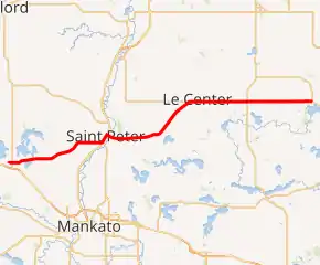
MN 99 highlighted in red | ||||
| Route information | ||||
| Maintained by MnDOT | ||||
| Length | 40.827 mi (65.705 km) | |||
| Existed | 1933–present | |||
| Major junctions | ||||
| West end | ||||
| East end | ||||
| Location | ||||
| Counties | Nicollet, Le Sueur, Rice | |||
| Highway system | ||||
| ||||

Route description

Highway 99 serves as an east–west route in south-central Minnesota between Nicollet, St. Peter, Cleveland, Le Center, and Faribault.
The route is also known as 3rd Street in the town of Nicollet.
Highway 99 follows Minnesota Avenue for 16 blocks in the city of St. Peter. The route is concurrent with U.S. Highway 169 and State Highway 22 throughout this length.
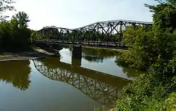
The route crosses the Minnesota River at St. Peter.
Highway 99 is also known as Derrynane Street in the city of Le Center.
History
Highway 99 was authorized on April 22, 1933.[1] It was posted in 1934 and included parts of what were previously State Highways 7 and 21. It was paved between Nicollet and Le Center at this time.[2] The section between Le Center and Highway 13 was paved in 1939,[3][4] and the last section between Highway 13 and Highway 21 was paved in 1952.[5][6]
Until the mid-1950s, Highway 99 turned directly north at Cleveland along what is now County Road 15 to intersect Highway 112. A shortcut heading northeast to Le Center was begun in 1953[7] and completed by 1956.[8]
Major intersections
| County | Location | mi | km | Destinations | Notes |
|---|---|---|---|---|---|
| Nicollet | Nicollet | 0.000 | 0.000 | ||
| 0.520 | 0.837 | ||||
| St. Peter | 12.337 | 19.854 | South end of US 169 overlap | ||
| South end of MN 22 overlap | |||||
| 13.376 | 21.527 | North end of US 169 / MN 22 overlap | |||
| Minnesota River | 13.414– 13.494 | 21.588– 21.716 | Broadway Bridge | ||
| Le Sueur | Lexington Township | 25.393 | 40.866 | ||
| Montgomery Township | 32.579 | 52.431 | |||
| Rice | Erin Township | 40.618 | 65.368 | ||
1.000 mi = 1.609 km; 1.000 km = 0.621 mi
| |||||
References
- "Chapter 440-H.F. No. 2000, Section 1", Session Laws of the State of Minnesota, Forty-Eighth Session, Mike Holm, Secretary of State, pp. 881–897.
- 1934 Map of Trunk Highway System, State of Minnesota (Map). Minnesota Highway Department. May 1, 1934. § J20-K20. Archived from the original on July 21, 2011. Retrieved November 15, 2010.
- 1939 Map of Minnesota Trunk Highway System (Map). Minnesota Highway Department. January 1, 1939. § K20. Archived from the original on July 21, 2011. Retrieved April 5, 2020.
- 1940 Map of Minnesota Trunk Highway System (Map). Minnesota Highway Department. January 1, 1940. § K20. Archived from the original on July 21, 2011. Retrieved April 5, 2020.
- 1952 Official Road Map of Minnesota (Map). Cartography by The H.M. Gousha Company. Minnesota Highway Department. January 1, 1952. § J17-K17. Archived from the original on July 21, 2011. Retrieved April 5, 2020.
- 1953 Official Road Map of Minnesota (Map). Cartography by The H.M. Gousha Company. Minnesota Highway Department. January 1, 1953. § J17-K17. Archived from the original on July 21, 2011.
- 1954 Official Road Map of Minnesota (Map). Cartography by The H.M. Gousha Company. Minnesota Highway Department. January 1, 1954. § J17. Archived from the original on July 21, 2011. Retrieved November 15, 2010.
- 1956 Official Road Map of Minnesota (Map). Cartography by The H.M. Gousha Company. Minnesota Highway Department. 1956. § J17. Archived from the original on July 21, 2011. Retrieved November 15, 2010.
External links
 Media related to Minnesota State Highway 99 at Wikimedia Commons
- Details of Routes 76 to 100, Steve Riner's Unofficial Minnesota Highways Page