Miraj
Miraj (![]() pronunciation ) is a city in southern Maharashtra, India, that was founded in the early 10th century. It was an important Jagir of the Adil Shahi Court of Bijapur
pronunciation ) is a city in southern Maharashtra, India, that was founded in the early 10th century. It was an important Jagir of the Adil Shahi Court of Bijapur
Miraj | |
|---|---|
City | |
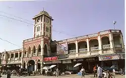 Laxmi Market Miraj | |
 Miraj | |
| Coordinates: 16.83°N 74.63°E | |
| Country | India |
| State | Maharashtra |
| District | Sangli |
| Government | |
| • Type | Municipal corporation |
| • Body | Sangli-Miraj and kupwad municipal corporation |
| • Mayor | Mrs. Sangita Khot |
| Population | |
| • Total | 355,000 |
| Demonym(s) | Mirajkar |
| Languages | |
| • Official | Marathi |
| Time zone | UTC+5:30 (IST) |
| PIN | 416410 |
| Telephone Code | 0233 |
| Vehicle registration | MH-10 |
Chatrapati Shivaji Maharaj stayed in Miraj for two months during his South India Campaign. Because of its location, Miraj has been held as a strategic bastion.It was the capital of Miraj Senior and is an important junction on the central railway network. The Pathwardhan family were the hereditary rulers of Miraj until independence.
City is part of the Sangli-Miraj-Kupwad Municipal Corporation formed in 1999. The city is recognised for Hindustani classical music and Medical services. Many medical tourists visit from adjoining districts of North Karnataka and from Arab countries. Ganesh festival is celebrated with great enthusiasm. The annual Ganesh Visarjan procession is an attraction that lasts for an average of twenty hours. Miraj also finds its mention in Ashi Hi Banwa Banwi and popular musical play and movie Katyar Kaljat Ghusli.
History
Early history
In 1024 AD, Miraj was ruled by Narsimha of the Silahar dynasty. From 1216 to 1316, the Yadavas of Devgiri ruled the town. In 1395, the Bahamanis conquered Miraj. Between 1391 and 1403, Miraj was affected by the Durgadevi famine. From 1423, Malik Imad Ul Mulk ruled Miraj. 1494 was the year of Bahadur Khan Gilani's rebellion. For two months of 1660, Shivaji Maharaj and Adilshah battled for control of Miraj. In 1680, Santaji Ghorpade became Deshmukhi of Miraj and six years later, the town was captured by Aurangzeb. In 1730, Chatrapati Shahu of Satara instructed Pant Pratinidhi to attack the town. Shahu gains power in Miraj on 3 October 1739 and brings Maratha rule. In 1761, Harbhat Patwardhan's son, Gopalrao, took the Miraj Jagir from Peshwa Madhavrao. In 1801, the Miraj was divided into two parts, Miraj and Chintamanrao with Sangli. In 1819, British rule is established and in 1948, the Princedom of Miraj becomes part of the Republic of India.
Shilahara (1000 to 1216)
At the end of the 9th century, the Silaharas of Kolhapur gained rule of Miraj. Jattiga II (circa 1000-1020 AD), the fourth ruler of Silahar dynasty, appears in the records of his son, Narasimha (circa 1050 to 1075 AD). Jattiga II was succeeded by his son, Gonka who has been described in inscriptions as the conqueror of Karahata (Karhad), Mirinj Miraj and Konkan. The Shilaharas were able to retain the rule of Miraj despite nearby military action by Chavan-raja, the general of Chalukya Jayasirhha II.
Yadavas and Bahamanis (1216 to 1347)
In 1216, Miraj, along with other territories of Silaharas, was conquered by the Yadavas. In 1318, the Bahamanis gained control. Historian, Tazkirat-ul-Mulk, reported that Hasan, the founder of the Bahamani dynasty, was in the employ of the Saikh Muhammad Junaidi at Gangi near Miraj. Hasan found a treasure with which he raised an army, marched on Miraj. He defeated and imprisoned Rani Durgavati, the subhedar of Miraj and captured the town's fort. At the behest of Saikh Muhammad, the name of the town was changed to Mubarakabad in 1347 (748 Hijri).
Fortress
The builder of the Miraj fort is unknown. It probably predates the Bahamani sultans even though they might have repaired it and increased its fortifications. They used the fort as a base for military expeditions against South Konkan and Goa. Firishta mentions the fort in an account of the rebellion of Bahadur Gilani in 1494, which was quelled by Sultan Muhammad II (1452–1515). Muhammad II took the fort from its governor, Buna Naik, who acquiesced to the new ruler. Gilani's troops were offered the option of joining Muhammad's army and being treated with leniency or leaving. About 2000 soldiers left the fort to join Gilani's rebel forces. The main entrance of the fortress was a huge gate about 30 ft (9.1 m) high but it has been demolished in recent times.
Fall of the Bahamani Empire
The power of the Bahamani rulers waned under the influence of powerful provincial governors. In 1490, the rule of Miraj passed to the Sultanate of Bijapur. During the later years of his reign, Ibrahim Ali Shah I (1534–1558) kept his son, Ali Adil Shah I (1558–1580), under house arrest in Miraj. On Ibrahim's death in 1580, Miraj became a point d' appui (an assembly point) for Ali's troops in his assuming the throne. Subsequently, the troops of Miraj fought with Ismail against Ibrahim Adil Sah III.
Rise of the Maratha Empire
On 28 November 1659, (within 18 days of Afzal Khan's, the Bijapuri sardar's, death at Pratapgad, Panhala), the western AdilShahi district was surrendered to Annaji Datto ( Chatrapati Shivaji Maharaj's finance minister). Unlike other towns, the Miraj fort resisted. Chatrapati Shivaji Maharaj, who was encamped at Kolhapur, sent Netaji Palkar to besiege Miraj. In January 1660, Chatrapati Shivaji Maharaj arrived to personally command the three-month-long ongoing siege. However, news of attacks by Siddi Johar and Fazal Khan caused his return to Panhala. The siege of Miraj was abandoned and negotiations began. Under the rule of Chatrapati Sambhaji Maharaj, Maratha generals (Santaji Ghorpade and Dhanaji Jadhav) chose Miraj as a safe place for their families while they were conducting guerilla actions against the invading Aurangzeb forces of the Mughal emperor.
Mughals
In 1687, Bijapur fell to the Mughals. Miraj remained under Mughal rule until 3 October 1739. On that day, it was captured by Shahu after a military campaign of two years, reflecting the fall of the last defences of the Mughals.
British Raj
The Patwardhan dynasty ruled Miraj as the capital of a principality, overseen by British rule. Miraj was part of the southern division of the Bombay Presidency which in turn was part of the southern Mahratta Jagirs, and later the Deccan States Agency. In 1820, the state of Miraj was divided into Miraj Senior and Miraj Junior. The territory of both regions was distributed among other native states and British districts. The area of Miraj Senior was 339 square miles (880 km2). In 1901, its population was 81, 467. Its revenue was £23,000 and the tax paid to the British was £800. The population of the town of Miraj in 1901 was 18, 425. It lay on a junction on the Southern Mahratta Railway.
Independence
On 8 March 1948, Miraj Senior acceded to the Dominion of India. At the present day, it is a part of the Maharashtra state.
Climate
| Climate data for Miraj (1981–2010, extremes 1968–2010) | |||||||||||||
|---|---|---|---|---|---|---|---|---|---|---|---|---|---|
| Month | Jan | Feb | Mar | Apr | May | Jun | Jul | Aug | Sep | Oct | Nov | Dec | Year |
| Record high °C (°F) | 36.1 (97.0) |
40.0 (104.0) |
42.3 (108.1) |
43.0 (109.4) |
42.9 (109.2) |
41.6 (106.9) |
35.8 (96.4) |
34.8 (94.6) |
36.5 (97.7) |
39.2 (102.6) |
35.1 (95.2) |
34.4 (93.9) |
43.0 (109.4) |
| Average high °C (°F) | 31.8 (89.2) |
34.1 (93.4) |
36.8 (98.2) |
38.5 (101.3) |
37.3 (99.1) |
31.5 (88.7) |
28.9 (84.0) |
28.4 (83.1) |
30.5 (86.9) |
32.1 (89.8) |
31.7 (89.1) |
31.0 (87.8) |
32.7 (90.9) |
| Average low °C (°F) | 14.4 (57.9) |
15.7 (60.3) |
18.8 (65.8) |
21.5 (70.7) |
22.4 (72.3) |
22.2 (72.0) |
21.6 (70.9) |
21.2 (70.2) |
20.9 (69.6) |
20.3 (68.5) |
17.4 (63.3) |
14.7 (58.5) |
19.2 (66.6) |
| Record low °C (°F) | 7.0 (44.6) |
8.6 (47.5) |
11.1 (52.0) |
14.2 (57.6) |
15.5 (59.9) |
18.5 (65.3) |
9.7 (49.5) |
17.4 (63.3) |
14.1 (57.4) |
13.3 (55.9) |
8.7 (47.7) |
6.5 (43.7) |
6.5 (43.7) |
| Average rainfall mm (inches) | 0.3 (0.01) |
0.2 (0.01) |
6.5 (0.26) |
21.6 (0.85) |
51.9 (2.04) |
137.9 (5.43) |
108.1 (4.26) |
89.2 (3.51) |
124.0 (4.88) |
115.6 (4.55) |
22.2 (0.87) |
4.5 (0.18) |
681.8 (26.84) |
| Average rainy days | 0.0 | 0.0 | 0.5 | 1.5 | 2.8 | 7.6 | 9.7 | 9.2 | 7.0 | 5.5 | 1.5 | 0.4 | 45.6 |
| Average relative humidity (%) (at 17:30 IST) | 39 | 31 | 30 | 31 | 45 | 68 | 75 | 76 | 69 | 56 | 49 | 45 | 51 |
| Source 1: India Meteorological Department[1] | |||||||||||||
| Source 2: Government of Maharashtra[2] | |||||||||||||
Demographics
As of the 2011 census, the population of the Miraj area is as follows.
| Religion | Total | Percentage |
|---|---|---|
| Hindu | 195,678 | 44.7% |
| Muslim | 245,890 | 50.0% |
| Jain | 21,727 | 4.32% |
| Christian | 6,930 | 1.38% |
| Buddhist | 6,953 | 1.38% |
| Not Stated | 1,235 | 0.25% |
| Sikh | 691 | 0.14% |
| Others | 526 | 0.10% |
Marathi is the official and most widely spoken language of the city. A unique kind of Hindi (Dakhini hydrabadi type) blended with Marathi is also spoken.[3]
Hindustani classical music
Miraj is a popular place for artists to perform at Urus. The administrative office of the Gandharva Mahavidyalaya is at Miraj. The city is known for its finesse in playing and manufacturing Sitars.
Musicians
- Vishnu Digambar Paluskar
- Bhatkhande
- Hirabai Badodekar
- Vinayakrao Patwardhan
- Bal Gandharva made his debut performance at Hans Prabha Theatre, Miraj. In the same location, the Balgandharva Natyagruha was named for him.
- Ustad Abdul Karim Khan, a doyen of the Kirana gharana, lies interred within the Hazrat Khawaja Shamna Mira RH and Hajrat Mira Saheb RH Dargah. An annual music festival at the dargah takes place in his memory.
- Ram Kadam (composer), Marathi Films Musician
String instruments
Miraj supplies Indian string instruments such as the Sitar, Sarod, and Tanpura. These are made of wood and specially treated gourds. The art of instrument making was developed by Faridsaheb Sitarmaker in the 18th century, and his descendants follow this tradition. The small area of Miraj is responsible for creating sitars and are renowned for their craftsmanship. The traditional craft of making this instruments is passed down generation to generation instilling the vitality of the small markets of Miraj.
Transportation
Railway
Miraj Junction railway station is an important junction on the Central Railway. It was the only junction to have all three rail gauges - broad gauge, narrow gauge and metre gauge. The last narrow gauge train departed on 1 November 2008. Miraj now has only broad gauge railway tracks. Miraj is connected by railway to Pune on the north, Kurduvadi via Pandharpur on north-northeast and Belgaum and Goa in the south. In February, 2011, passenger trains from Kolhapur to Solapur began running on the converted Miraj-Pandharpur-Kurduvadi broad gauge track.
Road
Miraj lies off the Mumbai-Pune-Bangalore national highway, NH4.
- Exit NH4 at Peth Naka while driving from north (from Mumbai and Pune).
- Exit NH4 at Shiroli Naka while driving from south (from Goa, Belgaum or Bangalore).
The two exits from NH4 form a triangle with Sangli and Miraj which lie about 50 km from each exit. Though the time taken to travel from Miraj is variable, depending on speed and other factors, Mumbai is about 7 hours and Bangalore is about 11 hours drive away.
See also
- Sir William James Wanless - Founder of Wanless Hospital.
- Dargah of Meerasaheb Avalia
- Shri Ayyappa Mandir, Miraj
- Ambedkar Udyan, Miraj
References
- "Station: Miraj (Sangali) Climatological Table 1981–2010" (PDF). Climatological Normals 1981–2010. India Meteorological Department. January 2015. pp. 497–498. Archived from the original (PDF) on 5 February 2020. Retrieved 10 April 2020.
- "Climate". Government of Maharashtra. Retrieved 10 April 2020.
- http://www.censusindia.gov.in/2011census/C-16_Town.html
External links
- The Municipal Corporation home page - Marathi language only as of 2006/10/09
- The List of the rulers of Miraj Senior
- Original article in the district Gazetteer
| History | 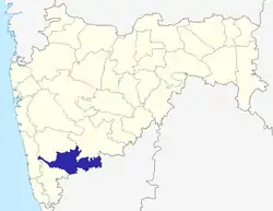 | |
|---|---|---|
| Geography | ||
| Cities and towns | ||
| Transport | ||
| Lok Sabha constituencies | ||
| Vidhan Sabha constituencies | ||
| Tehsil | ||
| Tourist attractions | ||
| Education | ||
