Mississippi Highway 30
Mississippi Highway 30 (MS 30) is a state highway that runs across the Appalachian Foothills of northeast Mississippi. It travels east–west for 78.9 miles (127.0 km) from MS 7 at Oxford, Mississippi to the Natchez Trace Parkway in Mingo near the Alabama state line.

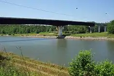
MS Highway 30 bridge passing over the Tennessee-Tombigbee Waterway near Paden
| ||||
|---|---|---|---|---|
| Route information | ||||
| Maintained by MDOT | ||||
| Length | 78.968 mi[1] (127.087 km) | |||
| Major junctions | ||||
| West end | ||||
| East end | ||||
| Location | ||||
| Counties | Lafayette, Union, Prentiss, Tishomingo | |||
| Highway system | ||||
| ||||
Major intersections
| County | Location | mi | km | Destinations | Notes |
|---|---|---|---|---|---|
| Lafayette | Oxford | Interchange; Western terminus | |||
| Union | | Northern terminus of MS 355 | |||
| | Southern terminus of MS 349 | ||||
| New Albany | Western end of I-22 / US 78 overlap; MS 30 west follows exit 61 | ||||
| Downtown New Albany | I-22 exit 63 | ||||
| Eastern end of I-22 / US 78 overlap; western end of MS 15 overlap; MS 30 east follows exit 64 | |||||
| Western terminus of MS 348 | |||||
| Eastern end of MS 15 overlap | |||||
| Pleasant Ridge | Eastern terminus of MS 370 | ||||
| Graham | Northern terminus of MS 9 | ||||
| Prentiss | Frankstown | Interchange; western end of US 45 overlap | |||
| Booneville | Interchange; eastern end of US 45 overlap | ||||
| Interchange | |||||
| | Interchange | ||||
| | Western terminus of MS 364 | ||||
| Burton | Southern terminus of MS 365 | ||||
| Tishomingo | | ||||
| Mingo | Interchange; eastern terminus | ||||
1.000 mi = 1.609 km; 1.000 km = 0.621 mi
| |||||
See also
| Wikimedia Commons has media related to Mississippi Highway 30. |
- List of Mississippi state highways
References
- "Mississippi Public Roads Selected Statistics" (PDF). Mississippi Department of Transportation. 2008. Archived from the original (PDF) on 2010-12-03. Retrieved 2010-06-03.
This article is issued from Wikipedia. The text is licensed under Creative Commons - Attribution - Sharealike. Additional terms may apply for the media files.
