Missouri Route 265
Route 265 is a highway in southwest Missouri. Its northern terminus is at Interstate 44 in Mount Vernon; its southern terminus is at U.S. Route 65 (for which it was numbered after) south of Branson. Much of the highway is concurrent with other routes (including Route 39, U.S. Route 60, Route 413, Route 13, Route 76, and Route 165). It is also known as the Ozark Mountain Parkway.
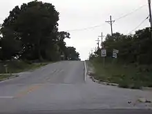
Route 265 east of Marionville at its junction with Route 413. This three-mile section is one of 3 short sections of the highway not concurrent with another highway, the other two being 5.6 miles from Route 76 to Route 165, near Table Rock Dam, and 3.2 miles from Route 165 to US 65 at its southern terminus.
| ||||
|---|---|---|---|---|
| Route information | ||||
| Length | 66.975 mi[1] (107.786 km) | |||
| Major junctions | ||||
| South end | ||||
| North end | ||||
| Highway system | ||||
| ||||

Major intersections
| County | Location | mi[1] | km | Destinations | Notes | |||
|---|---|---|---|---|---|---|---|---|
| Taney | Oliver Township | 0.000 | 0.000 | |||||
| 3.217 | 5.177 | Southern end of Route 165 / CR 165 overlap | ||||||
| Stone |
No major junctions | |||||||
| Taney | Branson | 7.264 | 11.690 | Northern end of Route 165 / CR 165 overlap | ||||
| Branson Township | 9.730 | 15.659 | ||||||
| Stone | Sunset Cove–Ruth township line | 12.851 | 20.682 | Southern end of Route 76 overlap | ||||
| Branson West | 16.938 | 27.259 | Southern end of Route 13 overlap | |||||
| Reeds Spring | 17.795 | 28.638 | Northern end of Route 13 and Route 76 overlaps; southern end of Route 413 overlap | |||||
| 19.747 | 31.780 | |||||||
| 21.353 | 34.364 | Southern end of Route 248 overlap | ||||||
| Galena | 28.922 | 46.545 | ||||||
| 29.306 | 47.163 | Southern end of Route 248 overlap | ||||||
| Elsey | 34.340 | 55.265 | ||||||
| Stone–Christian county line | Grant–West Polk– East Polk township tripoint | 45.310 | 72.919 | North end of Route 413 overlap | ||||
| Lawrence | Marionville | 48.446 | 77.966 | Southern end of US 60 overlap | ||||
| Aurora | 52.266 | 84.114 | ||||||
| 54.484 | 87.683 | Northern end of US 60 overlap; southern end of Route 39 overlap | ||||||
| 56.053 | 90.209 | |||||||
| Mount Vernon | 66.840– 66.975 | 107.569– 107.786 | Northern end of Route 39 overlap | |||||
1.000 mi = 1.609 km; 1.000 km = 0.621 mi
| ||||||||
References
- Missouri Department of Transportation (December 12, 2020). MoDOT HPMAPS (Map). Missouri Department of Transportation. Retrieved December 12, 2020.
This article is issued from Wikipedia. The text is licensed under Creative Commons - Attribution - Sharealike. Additional terms may apply for the media files.