Mokau River
The Mokau River is located in the North Island of New Zealand.
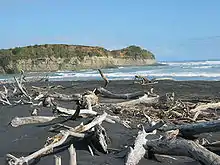
The river rises as a spring in the Pureora Forest, south of Te Kuiti, on the slopes of the Rangitoto Range. After briefly following a north-westward course, it turns south-westwards and flows for 158 kilometres (98 mi) through the Waitomo District of the King Country. It enters the North Taranaki Bight at its mouth at the town of Mokau.
Although the rivermouth is enclosed by a large sandbar, with a high tide, larger vessels can pass safely and enter the river, which is navigable for 37 kilometres (23 mi) upstream. In the late 19th century and early 20th century, the banks of the river were host to a thriving industry of logging and coal-mining. However, the risks and costs of transporting goods down the Mokau eventually ended such enterprise.
Today the river is a popular whitebaiting and kayaking location.
See also
References
- "Mokau River", An Encyclopaedia of New Zealand, edited by A. H. McLintock, 1966
- SS Mokau, Mōkau River, 1908
Further reading
- Mokau River resource inventory, New Plymouth, [N.Z.]: Dept. of Lands and Survey, 1986
- Gray, Brian E. (2007), The vital link : crossing the Mokau, Urenui, [N.Z.]: Pilot Gardens
- Hanchet, Stuart M.; Hayes, John W. (1989), Fish and fisheries values of the Mokau River and tributaries draining the Mokau coalfield, Rotorua, [N.Z.]: Freshwater Fisheries Centre, MAFFish
- Needham, Brad (2004), The variation in river mouth dynamics, spit and shoreline morphology at Mokau (M.Sc., University of Waikato)
- Smith, Brian J. (2007), Adult aquatic insect fauna of the Mokau River, Hamilton East, [N.Z.]: Environment Waikato Regional Council
External links
- Puke Ariki - Shooting Up The Mokau River
- Puke Ariki - Mokau River Holds Stories of Past
- Wairere Falls on 1:50,000 map
- Wairere Falls in 1908 - photo in Auckland Weekly News 30 JANUARY 1908 p13 (AWNS-19080130-13-1)
- 2014 upgrade of Wairere Falls power station and cross section
- Plan for additional power station shelved in 2011
- Auckland Weekly News photo of 1927 opening of Mokau Bridge
