Monroe Township, Carroll County, Indiana
Monroe Township is one of fourteen townships in Carroll County, Indiana. As of the 2010 census, its population was 2,797 and it contained 1,265 housing units.[3]
Monroe Township | |
|---|---|
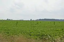 Fields west of Flora | |
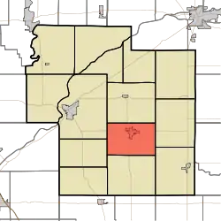 Location of Monroe Township in Carroll County | |
| Coordinates: 40°32′01″N 86°31′30″W | |
| Country | United States |
| State | Indiana |
| County | Carroll |
| Government | |
| • Type | Indiana township |
| Area | |
| • Total | 24.06 sq mi (62.3 km2) |
| • Land | 24.04 sq mi (62.3 km2) |
| • Water | 0.02 sq mi (0.05 km2) |
| Elevation | 709 ft (216 m) |
| Population (2010) | |
| • Total | 2,797 |
| • Density | 116.3/sq mi (44.9/km2) |
| FIPS code | 18-50256[2] |
| GNIS feature ID | 453635 |
History
Monroe Township was organized in 1840.[4]
Geography
According to the 2010 census, the township has a total area of 24.06 square miles (62.3 km2), of which 24.04 square miles (62.3 km2) (or 99.92%) is land and 0.02 square miles (0.052 km2) (or 0.08%) is water.[3]
Cities and towns
Unincorporated towns
Adjacent townships
- Jackson (north)
- Carrollton (east)
- Burlington (southeast)
- Democrat (south)
- Madison (west)
- Deer Creek (northwest)
Major highways
Cemeteries
The township contains three cemeteries: Maple Lawn, Moss, and Shirar Landis.
Education
Monroe Township residents may obtain a library card at the Flora-Monroe Township Public Library in Flora.[5]
References
- "US Board on Geographic Names". United States Geological Survey. 2007-10-25. Retrieved 2008-01-31.
- "U.S. Census website". United States Census Bureau. Retrieved 2008-01-31.
- "Population, Housing Units, Area, and Density: 2010 - County -- County Subdivision and Place -- 2010 Census Summary File 1". United States Census. Archived from the original on 2020-02-12. Retrieved 2013-05-10.
- Odell, John Curtis (1916). History of Carroll County, Indiana: Its People, Industries and Institutions. B.F. Bowen. p. 85.
- "Libraries". Carroll County, IN. Retrieved 4 March 2018.
External links
Municipalities and communities of Carroll County, Indiana, United States | ||
|---|---|---|
| City | Map of Indiana highlighting Carroll County | |
| Towns | ||
| Townships | ||
| Unincorporated communities |
| |
| ||
This article is issued from Wikipedia. The text is licensed under Creative Commons - Attribution - Sharealike. Additional terms may apply for the media files.