Carroll County, Indiana
Carroll County is a county located in the U.S. state of Indiana. As of the 2010 United States Census, the population was 20,155.[1] The county seat is Delphi.[2]
Carroll County | |
|---|---|
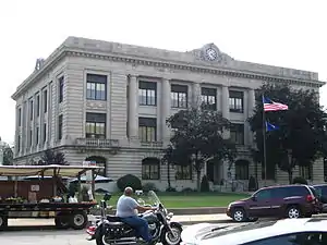 Carroll County courthouse in Delphi | |
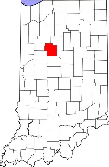 Location within the U.S. state of Indiana | |
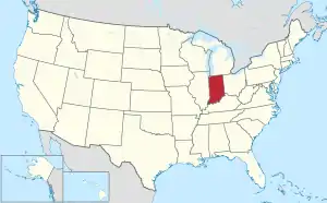 Indiana's location within the U.S. | |
| Coordinates: 40°35′N 86°34′W | |
| Country | |
| State | |
| Founded | 17 January 1828 (authorized) 28 April 1828 (organized) |
| Named for | Charles Carroll of Carrollton |
| Seat | Delphi |
| Largest city | Delphi |
| Area | |
| • Total | 375.02 sq mi (971.3 km2) |
| • Land | 372.22 sq mi (964.0 km2) |
| • Water | 2.80 sq mi (7.3 km2) 0.75%% |
| Population | |
| • Estimate (2018) | 20,127 |
| • Density | 54.1/sq mi (20.9/km2) |
| Time zone | UTC−5 (Eastern) |
| • Summer (DST) | UTC−4 (EDT) |
| Congressional district | 4th |
| Website | www |
| Indiana county number 8 | |
Carroll County is part of the Lafayette, Indiana, Metropolitan Statistical Area.
History
In 1787, the fledgling United States defined the Northwest Territory, which included the area of present-day Indiana. In 1800, Congress separated Ohio from the Northwest Territory, designating the rest of the land as the Indiana Territory.[3] President Thomas Jefferson chose William Henry Harrison as the territory's first governor, and Vincennes was established as the territorial capital.[4] After the Michigan Territory was separated and the Illinois Territory was formed, Indiana was reduced to its current size and geography.[3] By December 1816 the Indiana Territory was admitted to the Union as a state.
Starting in 1794, Native American titles to Indiana lands were extinguished by usurpation, purchase, or war and treaty. The United States acquired land from the Native Americans in the treaty of St. Mary's in 1818, which included most of the future county, and in 1826 the Treaty of Mississinewas made more area available for settlement. These two treaties resolved the occupation issue for the future Carroll County.
Whites had been living in the future Carroll County area since 1824[5] and their numbers increased rapidly in the next few years. Accordingly, Carroll County was authorized by the state legislature on 17 January 1828; it was named for Charles Carroll, the last surviving signer of the Declaration of Independence, who died in 1832.[5][6] The first commissioners began organizing the county government on 28 April of that year, and determined to site the county seat at land donated by William Wilson. The name 'Carrollton' was first suggested for the new community, but at the suggestion of General Samuel Milroy, 'Delphi' was selected instead.[5]
The Wabash and Erie Canal, built through the county in 1840 and operating until the early 1870s, is among the county's most significant historical legacies.
Courthouse
The first county courthouse was built in 1831. It was replaced by a brick structure in 1856. The 730-pound bell from the first courthouse was made in Cincinnati in 1836 and given by Sheriff Samuel Davis Gresham, and was used in the second courthouse until 1916. While the bell was in transit to Lafayette by boat, the boat sank. The bell was recovered from the Ohio River, and was sold, but was returned to Carroll County in 1967.[7]
The current Carroll County courthouse was designed by Jaxson Cowell of Indianapolis, who also designed the Spencer County courthouse. It was constructed by A. E. Kemmer at a cost of about $250,000 from 1916 to 1917. The exterior is understated, but the interior is surprisingly elaborate, including a stained glass dome over a mosaic tile floor.
Geography
The Wabash River flows southwestward from Cass County through the upper part of Carroll County, exiting into Tippecanoe County. The Tippecanoe River flows southward through the county's upper west edge, also exiting into Tippecanoe County, where it merges with the Wabash shortly after leaving Carroll County's border. Wildcat Creek drains the south part of Carroll County, flowing westward into Tippecanoe to merge with the Wabash there.
The terrain of Carroll County was heavily wooded at the start, but now the flat areas are cleared and devoted to agriculture or urban development, with only the drainage areas still wooded.[8] The highest point on the terrain (830 feet/253 meters ASL) is the county's SE corner.[9]
According to the 2010 census, the county has a total area of 375.02 square miles (971.3 km2), of which 372.22 square miles (964.0 km2) (or 99.25%) is land and 2.80 square miles (7.3 km2) (or 0.75%) is water.[10]
Adjacent counties
- Cass County − northeast
- Howard County − east
- Clinton County − south
- Tippecanoe County − southwest
- White County − northwest
City
- Delphi (county seat)
Towns
Unincorporated communities
Townships
Major highways
Climate and weather
| Delphi, Indiana | ||||||||||||||||||||||||||||||||||||||||||||||||||||||||||||
|---|---|---|---|---|---|---|---|---|---|---|---|---|---|---|---|---|---|---|---|---|---|---|---|---|---|---|---|---|---|---|---|---|---|---|---|---|---|---|---|---|---|---|---|---|---|---|---|---|---|---|---|---|---|---|---|---|---|---|---|---|
| Climate chart (explanation) | ||||||||||||||||||||||||||||||||||||||||||||||||||||||||||||
| ||||||||||||||||||||||||||||||||||||||||||||||||||||||||||||
| ||||||||||||||||||||||||||||||||||||||||||||||||||||||||||||
In recent years, average temperatures in Delphi have ranged from a low of 17 °F (−8 °C) in January to a high of 86 °F (30 °C) in July, although a record low of −25 °F (−32 °C) was recorded in January 1963 and a record high of 107 °F (42 °C) was recorded in July 1954. Average monthly precipitation ranged from 1.94 inches (49 mm) in February to 4.16 inches (106 mm) in July.[11]
Government
The county government is a constitutional body, and is granted specific powers by the Constitution of Indiana, and by the Indiana Code.
County Council: The legislative branch of the county government; controls spending and revenue collection in the county. Representatives are elected to four-year terms from county districts. They set salaries, the annual budget, and special spending. The council has limited authority to impose local taxes, in the form of an income and property tax that is subject to state level approval, excise taxes, and service taxes.[12][13]
Board of Commissioners: The executive body of the county; commissioners are elected county-wide to staggered four-year terms. One commissioner serves as president. The commissioners execute acts legislated by the council, collect revenue, and manage the county government.[12][13]
Court: The county maintains a small claims court that handles civil cases. The judge on the court is elected to a term of four years and must be a member of the Indiana Bar Association. The judge is assisted by a constable who is also elected to a four-year term. In some cases, court decisions can be appealed to the state level circuit court.[13]
County Officials: The county has other elected offices, including sheriff, coroner, auditor, treasurer, recorder, surveyor, and circuit court clerk. These officers are elected to four-year terms. Members elected to county government positions are required to declare a party affiliation and to be residents of the county.[13]
Carroll County is part of Indiana's 4th congressional district and is represented by Jim Baird in the United States Congress. It is also part of Indiana Senate district 7[14] and Indiana House of Representatives district 24.[15]
| Year | Republican | Democratic | Third parties |
|---|---|---|---|
| 2016 | 72.6% 6,273 | 21.9% 1,892 | 5.5% 478 |
| 2012 | 64.0% 4,999 | 33.7% 2,635 | 2.3% 176 |
| 2008 | 55.6% 4,858 | 42.8% 3,736 | 1.6% 142 |
| 2004 | 67.9% 5,868 | 31.1% 2,689 | 0.9% 81 |
| 2000 | 61.7% 5,102 | 35.9% 2,965 | 2.4% 201 |
| 1996 | 50.6% 4,062 | 34.2% 2,747 | 15.2% 1,222 |
| 1992 | 44.4% 3,800 | 29.9% 2,561 | 25.7% 2,201 |
| 1988 | 62.5% 4,981 | 37.1% 2,952 | 0.4% 31 |
| 1984 | 66.1% 5,528 | 33.2% 2,774 | 0.7% 62 |
| 1980 | 60.5% 5,262 | 34.1% 2,966 | 5.4% 471 |
| 1976 | 56.5% 4,797 | 42.5% 3,606 | 1.1% 90 |
| 1972 | 72.3% 5,885 | 27.2% 2,214 | 0.5% 38 |
| 1968 | 56.2% 4,796 | 33.0% 2,816 | 10.8% 923 |
| 1964 | 44.7% 3,896 | 55.0% 4,789 | 0.3% 29 |
| 1960 | 61.9% 5,411 | 37.7% 3,299 | 0.4% 34 |
| 1956 | 63.3% 5,748 | 36.5% 3,312 | 0.3% 26 |
| 1952 | 64.3% 5,902 | 35.0% 3,208 | 0.7% 68 |
| 1948 | 54.0% 4,597 | 45.2% 3,845 | 0.9% 72 |
| 1944 | 57.3% 4,872 | 42.1% 3,578 | 0.7% 55 |
| 1940 | 54.1% 5,012 | 45.4% 4,214 | 0.5% 47 |
| 1936 | 48.3% 4,426 | 51.0% 4,676 | 0.7% 65 |
| 1932 | 43.8% 3,853 | 55.3% 4,866 | 0.9% 80 |
| 1928 | 59.5% 4,780 | 39.6% 3,182 | 0.8% 66 |
| 1924 | 53.5% 4,543 | 43.1% 3,660 | 3.4% 286 |
| 1920 | 53.9% 5,006 | 45.1% 4,186 | 1.0% 92 |
| 1916 | 49.1% 2,468 | 47.8% 2,401 | 3.2% 159 |
| 1912 | 30.0% 1,467 | 46.6% 2,275 | 23.4% 1,143 |
| 1908 | 47.5% 2,546 | 48.3% 2,590 | 4.3% 229 |
| 1904 | 50.0% 2,671 | 45.3% 2,420 | 4.8% 255 |
| 1900 | 47.6% 2,585 | 49.5% 2,690 | 2.9% 157 |
| 1896 | 47.4% 2,546 | 51.5% 2,764 | 1.1% 58 |
| 1892 | 44.4% 2,230 | 47.0% 2,361 | 8.5% 428 |
| 1888 | 49.0% 2,607 | 48.1% 2,560 | 3.0% 158 |
Demographics
| Historical population | |||
|---|---|---|---|
| Census | Pop. | %± | |
| 1830 | 1,611 | — | |
| 1840 | 7,819 | 385.4% | |
| 1850 | 11,015 | 40.9% | |
| 1860 | 13,489 | 22.5% | |
| 1870 | 16,152 | 19.7% | |
| 1880 | 18,345 | 13.6% | |
| 1890 | 20,021 | 9.1% | |
| 1900 | 19,953 | −0.3% | |
| 1910 | 17,970 | −9.9% | |
| 1920 | 16,315 | −9.2% | |
| 1930 | 15,049 | −7.8% | |
| 1940 | 15,410 | 2.4% | |
| 1950 | 16,010 | 3.9% | |
| 1960 | 16,934 | 5.8% | |
| 1970 | 17,734 | 4.7% | |
| 1980 | 19,722 | 11.2% | |
| 1990 | 18,809 | −4.6% | |
| 2000 | 20,165 | 7.2% | |
| 2010 | 20,155 | 0.0% | |
| 2018 (est.) | 20,127 | [17] | −0.1% |
| US Decennial Census[18] 1790-1960[19] 1900-1990[20] 1990-2000[21] 2010-2013[1] | |||
2010 census
As of the 2010 United States Census, there were 20,155 people, 7,900 households, and 5,678 families in the county.[22] The population density was 54.1 inhabitants per square mile (20.9/km2). There were 9,472 housing units at an average density of 25.4 per square mile (9.8/km2).[10] The racial makeup of the county was 96.8% white, 0.2% American Indian, 0.2% black or African American, 0.1% Asian, 1.7% from other races, and 1.0% from two or more races. Those of Hispanic or Latino origin made up 3.5% of the population.[22] In terms of ancestry, 29.7% were German, 14.7% were American, 12.6% were Irish, and 8.8% were English.[23]
Of the 7,900 households, 32.1% had children under the age of 18 living with them, 59.5% were married couples living together, 7.3% had a female householder with no husband present, 28.1% were non-families, and 24.0% of all households were made up of individuals. The average household size was 2.54 and the average family size was 2.98. The median age was 40.9 years.[22]
The median income for a household in the county was $47,697 and the median income for a family was $60,420. Males had a median income of $46,241 versus $29,541 for females. The per capita income for the county was $23,163. About 6.1% of families and 9.4% of the population were below the poverty line, including 11.0% of those under age 18 and 8.3% of those age 65 or over.[24]
Education
Public schools in Carroll County are administered by the Carroll Consolidated School District and the Delphi Community School Corporation.
High schools and middle schools
- Delphi Community High School
- Delphi Community Middle School
- Carroll Consolidated School
Elementary schools
References
- "Carroll County QuickFacts". US Census Bureau. Archived from the original on 8 July 2011. Retrieved 17 September 2011.
- "Find a County". National Association of Counties. Archived from the original on 31 May 2011. Retrieved 7 June 2011.
- "Government at Crossroads: An Indiana chronology". The Herald Bulletin. 5 January 2008. Retrieved 22 July 2009.
- Brill, Marlene Targ (2005). Indiana. Marshall Cavendish. p. 35. ISBN 978-0-7614-2020-0.
- Odell, John Curtis (1916). History of Carroll County, Indiana: Its People, Industries and Institutions. B.F. Bowen. pp. 66–73.
- Gannett, Henry (1905). The Origin of Certain Place Names in the United States. Govt. Print. Off. pp. 70.
- Counts, Will; Jon Dilts (1991). The 92 Magnificent Indiana Courthouses. Bloomington, Indiana: Indiana University Press. pp. 22–23. ISBN 978-0-253-33638-5.
- Carroll County IN (Google Maps, accessed 21 September 2020)
- Carroll County High Point, Indiana (PeakBagger.com, accessed 21 September 2020)
- "Population, Housing Units, Area, and Density: 2010 - County". US Census Bureau. Archived from the original on 12 February 2020. Retrieved 10 July 2015.
- "Monthly Averages for Delphi, Indiana". The Weather Channel. Retrieved 27 January 2011.
- Indiana Code. "Title 36, Article 2, Section 3". IN.gov. Retrieved 16 September 2008.
- Indiana Code. "Title 2, Article 10, Section 2" (PDF). IN.gov. Retrieved 16 September 2008.
- "Indiana Senate Districts". State of Indiana. Retrieved 23 January 2011.
- "Indiana House Districts". State of Indiana. Retrieved 23 January 2011.
- Leip, David. "Atlas of US Presidential Elections". uselectionatlas.org. Retrieved 14 May 2018.
- "Population and Housing Unit Estimates". Retrieved July 26, 2019.
- "US Decennial Census". US Census Bureau. Retrieved July 10, 2014.
- "Historical Census Browser". University of Virginia Library. Retrieved July 10, 2014.
- "Population of Counties by Decennial Census: 1900 to 1990". US Census Bureau. Retrieved July 10, 2014.
- "Census 2000 PHC-T-4. Ranking Tables for Counties: 1990 and 2000" (PDF). US Census Bureau. Retrieved July 10, 2014.
- "DP-1 Profile of General Population and Housing Characteristics: 2010 Demographic Profile Data". US Census Bureau. Archived from the original on 13 February 2020. Retrieved 10 July 2015.
- "Selected Social Characteristics in the US – 2006-2010 American Community Survey 5-Year Estimates". US Census Bureau. Archived from the original on 14 February 2020. Retrieved 10 July 2015.
- "Selected Economic Characteristics – 2006-2010 American Community Survey 5-Year Estimates". US Census Bureau. Archived from the original on 14 February 2020. Retrieved 10 July 2015.
External links
- Carroll County official website
- Carroll Consolidated School District
- Delphi Community School Corporation
Places adjacent to Carroll County, Indiana | ||||||||||
|---|---|---|---|---|---|---|---|---|---|---|
| ||||||||||
Municipalities and communities of Carroll County, Indiana, United States | ||
|---|---|---|
| City | Map of Indiana highlighting Carroll County | |
| Towns | ||
| Townships | ||
| Unincorporated communities |
| |
| ||

| Authority control |
|---|