Montagu, Western Cape
Montagu is a town in the Western Cape province of South Africa, about 180 kilometres (110 mi) from Cape Town in the Western Little Karoo. It is named after former secretary of the Cape Colony, John Montagu, but was once known as Agter Cogman’s Kloof, Cogman’s Kloof linking the town and railway station. It is situated at the confluence of the Keisie and Kingna rivers.
Montagu | |
|---|---|
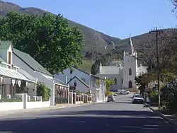 Street in Montagu | |
 Montagu  Montagu | |
| Coordinates: 33°47′S 20°7′E | |
| Country | South Africa |
| Province | Western Cape |
| District | Cape Winelands |
| Municipality | Langeberg |
| Established | 1856[1] |
| Area | |
| • Total | 32.71 km2 (12.63 sq mi) |
| Population (2011)[2] | |
| • Total | 15,176 |
| • Density | 460/km2 (1,200/sq mi) |
| Racial makeup (2011) | |
| • Black African | 6.4% |
| • Coloured | 75.7% |
| • Indian/Asian | 0.5% |
| • White | 16.4% |
| • Other | 1.0% |
| First languages (2011) | |
| • Afrikaans | 91.2% |
| • English | 5.5% |
| • Xhosa | 1.5% |
| • Other | 1.9% |
| Time zone | UTC+2 (SAST) |
| Postal code (street) | 6720 |
| PO box | 6720 |
| Area code | 023 |
| Website | http://www.montagu-ashton.info |
Montagu was founded on the farm "Uitvlugt" in 1851, and is known for its hot mineral springs and scenic mountains. It is also an agricultural centre, where orchards and vineyards are in production and local herbs are grown. The farming area, 'Koo', lies north of the town and is famous for the quality of its apples, pears, apricots and peaches. The author Francis Brett Young spent his final years here. Nearby rock formations make it one of the country's major rock climbing venues. The 1266 m high Bloupunt peak overlooks the village and offers several hiking trails, as well as kloofing and mountain biking trails further afield.
Montagu is near the Robertson Wine Valley, and is most easily reached via the Route 62 scenic route.
See also
References
- "Chronological order of town establishment in South Africa based on Floyd (1960:20-26)" (PDF). pp. xlv–lii.
- "Main Place Montagu". Census 2011.
External links
| Wikimedia Commons has media related to Montagu, Western Cape. |
- Official website

 Montagu travel guide from Wikivoyage
Municipalities and communities of Cape Winelands District Municipality, Western Cape | ||
|---|---|---|
District seat: Stellenbosch | ||
| Witzenberg | .svg.png.webp) Cape Winelands District within South Africa | |
| Drakenstein | ||
| Stellenbosch | ||
| Breede Valley | ||
| Langeberg | ||