Monyoród
Monyoród (Croatian: Minjorod, German: Munjerod) is a village and municipality (Hungarian: község) in Baranya county, Hungary.
Monyoród
Minjorod | |
|---|---|
Municipality | |
 Coat of arms | |
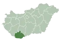
 Monyoród Location within Hungary. | |
| Coordinates: 46°0′28.22″N 18°28′48.94″E | |
| Country | |
| Region | Southern Transdanubia |
| County | Baranya |
| District | Bóly |
| Government | |
| • Type | Mayor-council government |
| • Mayor | György Horváth (Ind.) |
| Area | |
| • Total | 7.12 km2 (2.75 sq mi) |
| Population (2018)[2] | |
| • Total | 136 |
| • Density | 19/km2 (49/sq mi) |
| Time zone | UTC+1 (CET) |
| • Summer (DST) | UTC+2 (CEST) |
| Postal code | 7751 |
| Area code(s) | 69 |
| Geocode | 16027 |
Geography
Monyoród is located in east central Baranya County, about halfway between Pécs and Mohács, and 10 kilometers north of Bóly. The municipality lies within the Southern Transdanubia Region of Hungary. It previously was part of the Mohács Subregion but during the creation of districts in 2013, it became part of Bóly District.
Demographics
During the census of 2011, the population was 163. The majority of the population claimed Hungarian ethnicity (64.9%). Other ethnicities claimed included German (14.9%), Croatian (8.4%), Roma (1.3%) and Romanian (1.3%). 33.1% did not wish to answer. In terms of religious practice, 45.5% reported to be Roman Catholic, 7.1% Calvinist, 8.4% of no religious affiliation and 39% did not wish to answer.[3]
Transport
The closest railway station is in Bóly, 10 kilometers to the south.
References
- "Municipal Elections 2014" (in Hungarian). Hungarian National Election Office. Retrieved 5 June 2019.
- "Gazetteer of Hungary, 1st January 2018". Hungarian Central Statistical Office. Retrieved 5 June 2019.
- "Detailed Gazetteer of Hungary". Hungarian Central Statistical Office. Retrieved 5 June 2019.