Moro, Kwara
Moro is a Local Government Area in Kwara State, Nigeria. It has an area of 3,272 km2 and a population of 108,792 at the 2006 census.
Moro | |
|---|---|
LGA | |
| Country | |
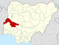
| State | Kwara State |
| Time zone | UTC+1 (WAT) |
The postal code of the area is 241.[1]
References
- "Post Offices- with map of LGA". NIPOST. Archived from the original on 2009-10-07. Retrieved 2009-10-20.
State capital: Ilorin | ||
| Governors |
|  |
| LGAs | ||
| Cities | ||
| Towns |
| |
This article is issued from Wikipedia. The text is licensed under Creative Commons - Attribution - Sharealike. Additional terms may apply for the media files.