Most northerly point of land
The most northerly point of land on Earth is a contentious issue due to variation of definition. Issues of how permanent some of the contenders are is problematic as ice sheets and the shallow water depth make movement and inundation combined with observational difficulties due to remoteness, make any hard determination difficult. The following table sets out the main contenders for this title.
| Island name | Coordinates | Distance from pole | Discovered by | Permanent | Notes |
|---|---|---|---|---|---|
| 83-42[1] | 83°42′05.2″N,30°38′49.4″W | 700.5 km | Dennis Schmitt | unknown | 35 m by 15 m and 4 m high |
| Ultima Thule 2008 | 83 ° 41 'N, 31 ° 6' W | 702.4km | unknown | ||
| RTOW2001 | 83° 41′06″N, 30°45′36″W | 702.5 km | RTOWexpedition | unknown | |
| ATOW1996[2] | 83°40′34.8″N, 30°38′38.6″W | 703.2km | ATOWexpedition | unknown | 10 m long and 1 m high |
| Stray Dog West[3][4] | 83°40'30"N | 703.3km | Dennis Schmitt | unknown | Needs confirmation |
| Oodaaq | 83°40′N, 30°40′W | 704.2km | Uffe Petersen | No | 15 m by 8 m, appears to be submerged periodically |
| Kaffeklubben Island[5] | 83°39′45N, 29°50′W. | 704.7 km | Robert Peary | yes | 700 m by 300 m by 30 m high |
| Cape Morris Jesup | 83°37′39″N, 32°39′52″W | 708.6 km | Robert Peary | yes | Northernmost Greenland. |
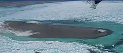
Kaffeklubben Island in 2008
See also
References
- The World's Northernmost Point Is Called 83-42. Maybe. The Daily Traveller, February 16, 2012
- Jancik, John; Richardson, Javana; & Gardiner, Steve (2002). Under the Midnight Sun: The Ascent of John Denver Peak and the Search for the Northernmost Point of Land on Earth.
- Stray Dog West photograph Archived 2011-05-22 at the Wayback Machine taken on 2007-07-16.
- John H. Richardson, Journey to the End of the Earth Esquire Magazine 2007-09-18.
- Funder, S.; Larsen, O. (Nov 15, 1982). "Implications of volcanic erratics in Quaternary deposits of North Greenland" (PDF). Bulletin of the Geological Society of Denmark. 31: 57–61. ISSN 0011-6297.
This article is issued from Wikipedia. The text is licensed under Creative Commons - Attribution - Sharealike. Additional terms may apply for the media files.