Mount Aniakchak
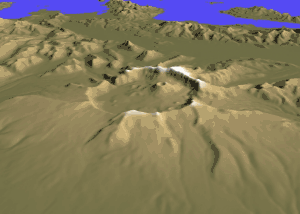
Mount Aniakchak (Russian: Аниакчак) is a 3,700-year-old volcanic[2] caldera approximately 10 kilometers (6 mi) in diameter, located in the Aleutian Range of Alaska, United States. Although a stratovolcano by composition, the pre-existing mountain collapsed in a major eruption forming the caldera.[3] The area around the volcano is the Aniakchak National Monument and Preserve, maintained by the National Park Service. In November 1967, Aniakchak Caldera was designated as a National Natural Landmark by the National Park Service.[4]
| Aniakchak Caldera | |
|---|---|
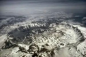 Mount Aniakchak caldera | |
| Highest point | |
| Elevation | 4,232 ft (1,290 m) [1] |
| Coordinates | 56°51′47″N 158°07′47″W [1] |
| Geography | |
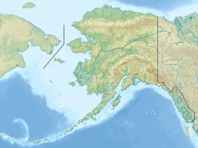 Aniakchak Caldera Alaska | |
| Location | Aniakchak National Monument and Preserve, Alaska, U.S. |
| Parent range | Aleutian Range[2] |
| Topo map | USGS Chignik D-1 |
| Geology | |
| Mountain type | Caldera (Stratovolcano)[2][3] |
| Volcanic arc/belt | Aleutian Arc |
| Last eruption | May to June 1931[1] |
| Designated | November 1967 |
Geological history
Mount Aniakchak was previously a glacially eroded stratovolcano of andestic composition, with a pre-caldera volume of 75 cubic kilometres (18 cu mi). Andesitic material in the volcano included basalt and dacite. The mountain collapsed, forming the present day caldera, during a major eruption of VEI=6, which left evidence in ice cores dated to 1645 BC.[5][3] which was later moved to 1641 BC in the Greenland Ice Core Chronology 2005 (GICC05) time scale.[6][7] Recently, McAneney and Baillie have suggested that the GICC05 ice core dates in the 17th century BC may be around 14 years too old, meaning that Aniakchak actually erupted in 1628 or 1627 BC.[8]
Since then, more than 20 eruptions have occurred from vents on the caldera floor. Vent Mountain has been the source of numerous eruptions of ash, bombs, and lava flows since the caldera formed. From 1500 BC to AD 1000 four lava domes were extruded on the caldera floor. Textural evidence shows that these lava-dome eruptions occurred beneath Ancient Surprise Lake which was as deep as 100m. Ancient Surprise Lake drained catastrophically before about AD 1000. (Surprise Lake (Aniakchak's crater lake) is now about 2.75 km2 (680 acres) in area and up to 19.5 m (64.0 ft) deep.) Before or immediately after this draining, explosive eruptions of andesitic magma produced a cluster of three tuff cones in the southeast part of the caldera.
Around AD 1500, during one of the most violent events in recent history at Aniakchak, an estimated 0.75 to 1.0 km3 of material destroyed a preexisting edifice at Half Cone and flooded most of the caldera floor with pyroclastic flows, surges, and fallout many meters thick. During the final phase of this eruption, a lava flow filled the basin formed during the collapse of Half Cone.
Several more recent prehistoric eruptions occurred in the summit crater and along the south flank of Vent Mountain producing a field of blocky dacite lava flows against the south wall of the caldera. Minor eruptions immediately west and east of Vent Mountain produced a small scoria cone (Blocky Cone) and two maar craters (now water-filled) along the base of the southeast caldera wall.
European-descended geologists discovered the volcano in 1922.
The volcano's only eruption in modern recorded history occurred in 1931. The Jesuit "Glacier Priest", Father Bernard Hubbard, made record of it: "A small but impressive explosion pit was added to the pockmarked caldera floor that year. Many thousands of tons of ash lay strewn within the caldera and scattered up to 40 miles away over the small villages".[9]
Human history
The caldera-forming eruptions of ~3,700 years ago had a significant effect on the regional landscape, and on the entire range of plant and animal life over a broad area. Indeed, the eruption has been implicated in widespread impacts on human populations across the whole of western Alaska.[10] In the immediate vicinity of the volcano, the effects were so severe that people did not return to the region for another 2,000 years.[11] Some scholars speculate that this eruption (and the subsequent devastation) may have segregated people to the north and south of the volcano for long enough to drive the divergence between Aleutian and Eskimoan languages.[12]
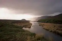
Surprise Lake
Surprise Lake within the caldera is the source of the Aniakchak River, a National Wild River.
References
- "Aniakchak Peak". Geographique Names Information system. United States Geological Survey. Retrieved 2015-05-05.
- "Aniakchak". Global Volcanism Program. Smithsonian Institution. Retrieved 2009-01-19.
- Volcanoes of North America : United States and Canada (1st pbk. ed.). Cambridge [England]: Cambridge University Press. 1992. pp. 59 and 60. ISBN 9780521438117. OCLC 27910629.
- "National Natural Landmarks - National Natural Landmarks (U.S. National Park Service)". www.nps.gov. Retrieved 2019-03-20.
- Pearce, N. J. G., J. A. Westgate, S. J. Preece, W. J. Eastwood, and W. T. Perkins (2004). "Identification of Aniakchak (Alaska) tephra in Greenland ice core challenges the 1645 BC date for Minoan eruption of Santorini". Geochem. Geophys. Geosyst. 5 (3): Q03005. Bibcode:2004GGG.....5.3005P. doi:10.1029/2003GC000672.CS1 maint: multiple names: authors list (link)
- "The GICC05 time scale". Centre for Ice and Climate - University of Copenhagen. Retrieved September 17, 2018.
- Vinther, B. M., Clausen, H. B., Johnsen, S. J., Rasmussen, S. O., Andersen, K. K., Buchardt, S. L., Dahl-Jensen, D., Seierstad, I. K., Siggaard-Andersen, M. L., Steffensen, J. P., Svensson, A., Olsen, J., and Heinemeier, J. (2006). "A synchronized dating of three Greenland ice cores throughout the Holocene". J. Geophys. Res. 111 (D13): D13102. Bibcode:2006JGRD..11113102V. doi:10.1029/2005JD006921.CS1 maint: multiple names: authors list (link)
- McAneney, J. and Baillie, M.G.L. (2019). "Absolute tree-ring dates for the Late Bronze Age eruptions of Aniakchak and Thera in light of a proposed revision of ice-core chronologies". Antiquity. 93 (367): 99–112. doi:10.15184/aqy.2018.165.CS1 maint: multiple names: authors list (link)
- "Aniakchak National Monument & Preserve", pulled from chranger.com, 3 June 2011.
- VanderHoek, Richard (2009). The role of ecological barriers in the development of cultural boundaries during the later Holocene of the central Alaska Peninsula. Urbana: PhD Dissertation in Anthropology, University of Illinois at Urbana-Champaign.
- Barton, Loukas; Shirar, Scott; Jordan, James W. (March 2018). "Holocene Human Occupation of the Central Alaska Peninsula". Radiocarbon. 60 (2): 367–382. doi:10.1017/rdc.2018.2. ISSN 0033-8222.
- Dumond, Don E. (2004). "Volcanism and history on the northern Alaska Peninsula". Arctic Anthropology. 41 (2): 112–125. doi:10.1353/arc.2011.0023. S2CID 130379617.
