Mount Kamui (Lake Mashū caldera)
Mount Kamui (カムイヌプリ, Kamui-nupuri [1]), also Kamuinupuri or Mount Mashū, a potentially active volcano, is a parasitic stratovolcano of the Mashū caldera (itself originally a parasitic cone of Lake Kussharo)[2][3][4] located in the Akan National Park of Hokkaido, Japan.
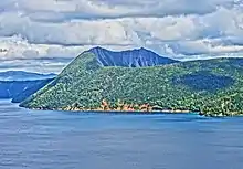
Mount Kamui rising above Lake Mashū.
| Mount Kamui | |
|---|---|
| カムイヌプリ | |
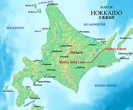 Map of Hokkaido showing location of Mount Kamui and Lake Mashū. | |
| Highest point | |
| Elevation | 857 m (2,812 ft) |
| Listing | List of mountains and hills of Japan by height |
| Coordinates | 43°34′20″N 144°33′39″E |
| Naming | |
| English translation | mountain of the gods |
| Language of name | Ainu |
| Geography | |
| Location | Hokkaido, Japan |
| Parent range | Daisetsuzan Volcanic Group |
| Topo map | Geographical Survey Institute 25000:1 摩周湖南部, 50000:1 摩周湖 |
| Geology | |
| Mountain type | stratovolcano |
| Volcanic arc/belt | Kurile arc |
| Last eruption | 970 AD ± 100 years |
| Climbing | |
| Easiest route | Hike |
Volcanism
Mount Kamui rose on the rim of 6 km-wide Mashū caldera, about four thousand years ago, after the collapse of Mashū volcano. Its last eruption took place about 1000 years ago.[5]
Tourism
Hikers can follow a 7.2 km wooded trail to the peak of the mountain, walking along the ridge of the caldera, which is a 300-m vertical drop to the surface of the Lake Mashū.[6]
References
- "Kamui-nupuri: Japan". Geograpnical Names. Retrieved 2011-03-08.
- "Geospatial Information Authority of Japan". Retrieved 2011-03-08.
- "KAMUINUPURI". Quaternary Volcanoes of Japan, Geological Survey of Japan, AIST, 2006. Archived from the original on 2012-07-14. Retrieved 2011-03-08.
- "Mashu". Global Volcanism Program, Smithsonian National Museum of Natural History. Retrieved 2020-03-24.
- "Mashu caldera, Japan". Volcano Photos. Retrieved 2011-03-08.
- "カムイヌプリ(摩周岳)( 857m) [第一展望台コース". 一人歩きの北海道山紀行. Archived from the original on 2011-08-26. Retrieved 2011-03-08.
This article is issued from Wikipedia. The text is licensed under Creative Commons - Attribution - Sharealike. Additional terms may apply for the media files.