Mueang Songkhla District
Mueang Songkhla District (Thai: เมืองสงขลา, pronounced [mɯ̄a̯ŋ sǒŋ.kʰlǎː]; Pattani Malay: ซิงกอรอ, pronounced [sīŋ.kɔː.rɔː]) is the capital district (amphoe mueang) of Songkhla Province, southern Thailand.
Mueang Songkhla
เมืองสงขลา | |
|---|---|
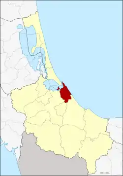 District location in Songkhla Province | |
| Coordinates: 7°12′25″N 100°35′47″E | |
| Country | Thailand |
| Province | Songkhla |
| Seat | Bo Yang |
| Subdistricts | 6 |
| Mubans | 47 |
| Area | |
| • Total | 171.9 km2 (66.4 sq mi) |
| Population (2014) | |
| • Total | 163,329 |
| • Density | 948.7/km2 (2,457/sq mi) |
| Time zone | UTC+7 (ICT) |
| Postal code | 90000 |
| Geocode | 9001 |
Geography
Neighboring districts are (from the south clockwise): Chana, Na Mom, Hat Yai, and Singhanakhon of Songkhla Province. To the east is the Gulf of Thailand.
In the northern part of the district is Songkhla Lake.
History
The name Songkhla is a Thai corruption of Singgora, its original name, which means 'the city of lions' in Malay. It refers to a lion-shaped mountain near the city of Songkhla.
Administration
Central administration
Mueang Songkhla District is divided into six sub-districts (tambons), which are further subdivided into 47 administrative villages (mubans).
| No. | Name | Thai | Villages | Pop.[1] |
|---|---|---|---|---|
| 1. | Bo Yang | บ่อยาง | - | 67,154 |
| 2. | Khao Rup Chang | เขารูปช้าง | 10 | 39,231 |
| 3. | Ko Taeo | เกาะแต้ว | 10 | 11,121 |
| 4. | Phawong | พะวง | 8 | 30,541 |
| 5. | Thung Wang | ทุ่งหวัง | 10 | 10,396 |
| 6. | Ko Yo | เกาะยอ | 9 | 4,886 |
Local administration
There is one city (thesaban nakhon) in the district:
- Songkhla (Thai: เทศบาลนครสงขลา) consisting of sub-district Bo Yang.
There is one town (thesaban mueang) in the district:
- Khao Rup Chang (Thai: เทศบาลเมืองเขารูปช้าง) consisting of sub-district Khao Rup Chang.
There are two sub-district municipalities (thesaban tambons) in the district:
- Phawong (Thai: เทศบาลตำบลพะวง) consisting of sub-district Phawong.
- Ko Taeo (Thai: เทศบาลตำบลเกาะแต้ว) consisting of sub-district Ko Taeo.
There are two sub-district administrative organizations (SAO) in the district:
- Thung Wang (Thai: องค์การบริหารส่วนตำบลทุ่งหวัง) consisting of sub-district Thung Wang.
- Ko Yo (Thai: องค์การบริหารส่วนตำบลเกาะยอ) consisting of sub-district Ko Yo.
References
- "Population statistics 2014" (in Thai). Department of Provincial Administration. Retrieved 2015-06-14.
