Munsiari
Munsiyari (Devanagari: मुनस्यारी ) is the name of the sub-division headquarters, a conglomeration of revenue villages and it also refers to the entire region as Munsiyari Tehsil and Sub Division in the Pithoragarh District in the hill-state of Uttarakhand, India.
Munsiyari
Munsiari | |
|---|---|
Sub-division | |
.jpg.webp) _(2).jpg.webp)  _(2).jpg.webp)  Clockwise from top: A view of the Gori river flowing through Johar Valley, Birthi Falls, as seen from Thal-Munsiyari road, Nanda Devi Temple, View of Panchchuli Peaks and Tribal Heritage Museum. | |
 Munsiyari Location in Uttarakhand, India  Munsiyari Munsiyari (India) | |
| Coordinates: 30.067413°N 80.238562°E | |
| Country | |
| State | Uttarakhand |
| District | Pithoragarh |
| Elevation | 2,200 m (7,200 ft) |
| Languages | |
| • Official | Hindi, Kumaoni |
| Time zone | UTC+5:30 (IST) |
| PIN | 262554 |
| Vehicle registration | UK |
| Website | uk |
It is a hill station and lies at the base of the great Himalayan mountain range, at an elevation of about 2,200 m (7,200 ft)[1] and is a starting point of various treks into the interior of the range.
Establishment
During a summer festival organized in Munsiyari market in 2013, a proposal for granting Munsiyari the status of Nagar Panchayat (lower level Municipality) was passed by the locals.[2] Gram Panchayats attached to the Munsiyari market had also given their consent for this.[2] On 28 February 2014, the Uttarakhand Cabinet decided to grant Nagar Panchayat status to the towns of Munsiyari, Chaukhutia and Naugaon.[3] Shortly afterwards, the then Chief Minister Harish Rawat made an announcement confirming this move while on a visit to the town.[4] The municipal area was to be created by incorporating 5 Gram Panchayats: Mallaghorpatta, Tallaghorpatta, Bunga, Sarmoli and Jainti.[4] An official notification was issued on 7 October 2014, but due to major opposition by the Gram Sabhas, the Nagar Panchayat could not come into existence.[5] In June 2015, several government officials visited the area and tried to initiate talks with local villagers.[6] After all the talks failed, the notification that allowed the formation of Nagar Panchayat was revoked on 22 August 2016.[4]
Overview
In local parlance, the name 'Munsiyari' refers to a 'place with snow'. Situated on the banks of Goriganga river, it is a fast-growing tourist destination, and mountaineers, glacier enthusiasts, high altitude trekkers and nature lovers commonly use it as their hub or base camp. Munsiyari also falls on the ancient salt route from Tibet and is at the entrance of the Johar Valley, which extends along the path of the Gori Ganga river to its source at the Milam Glacier. It is inhabited mainly by people of a few different caste groups including the Shauka tribe, dalits or Scheduled Castes and people categorized in other general castes comprising Kshatriya's, Pandits with a few Sikhs, Christians and Buddhists.
Munsiyari bazaar is a conglomeration of revenue villages and is not categorized as a town. The bazaar area comprises the villages of Malla Ghorpatta and Bunga, while Naya Basti, Sarmoli, Nana Sem, Jainti, Papdi villages form the periphery of the area popularly called Munsiyari. The main bazaar area faces east towards the Himalayan Panchachuli ranges.
The upper part of Munsiyari is called Malla Johar, which comprises 14 trans-humant alpine villages, that are seasonally occupied during the months of May to early November.
Economy
Principally subsistence based agriculture and animal husbandry and allied activities. Many families are dependent on forests and natural resources for their livelihoods.[7]
Traditionally medicinal plants have been collected for own use and for trade, however since 2000 there has been a tremendous increase in the extraction of Yarsa-Gombu or Keeda Ghas (Ophiocordyceps sinensis) which has changed the economy and scale of collection from the wild.
Tourism is an emerging industry with private, community and the state government building a variety of resources and facilities to host tourists.
The traditional livelihood of trade, specially with Tibet, ceased after the 1962 war with China.
Common Agricultural Crops
Medicinal Plants and Fungus
- Yarsa-Gombu or Keeda Ghas (Ophiocordyceps sinensis)
- Timur (Zanthoxylum alatum)
- Cannabis (Cannabis sativa)
- Ganjari (Chaerophyllum villosum)
- Hathajari (Orchis latifolia)
Key Attractions

Some of the more popular day trip destinations are
- Khalia Peak (3747 meters / 12290 feet)
- Mesar Kund (A Small Forest Pond in Sarmoli and Shankhdhura Villages)
- Thamri Kund (Another pond on the Betuli Dhar ridge)
- Betuli Dhar
- Darkot Village
- Dana Dhar Ridge
- Sarmoli Village
- Hotspings at Madkot and Sera
- Gori Ganga River
- Balati Farm
- Tribal Heritage Museum (Opened by Lt. Dr Sher Singh Pangtey)
Trekking Routes
The main trekking route is to Milam Village and Glacier
Milam Glacier : Munsiyari is the point from where the trek to Milam glacier commences :
- Munsiyari (2200 m) to Lilam 12 km (P.W.D. Rest House)
- Lilam (1810 m) to Bagudiyar 13 km -----
- Bagudiyar (2450 m) to Rilkote 12 km -----
- Rilkote (3350 m) to Burfu 9 km -----
- Burfu (3450 m) to Milam 8 km (P.W.D. Rest House)
- Milam (3500 m) to Milam Glacier 5 km
- Total route 59 km
Ralam Glacier
- Munsiyari to Lilam Patan Gaon 15 km
- Patan Gaon to Sophiya Udiyar 15 km
- Sophiya Udiyar to Ralam 15 km
- Total Route 45 km
Natural History
Birds
A part of the administrative region of Munsiari is located in the Gori river basin. As of May 2014 a total of 319 birds[8] have been recorded, constituting a quarter of India's birds. Species richness apart, the Gori river basin harbours many rare, endemic, globally threatened and endangered bird species, including many of the evolutionarily older birds on the India Sub-continent. The region has been designated by Birdlife International as an Important Bird Area.[9]
Lichen Park
The Uttarakhand Forest Department has developed a lichen park in Munsiari, which is spread across 1.5 acres. It is India's first lichen park and its development started in 2019.[10][11]
Gallery
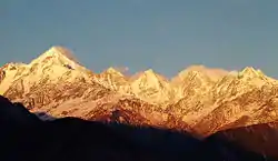 Panchchuli Peaks at Sunset, near Munsyari
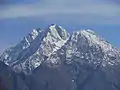 Hansling Peak from Munsyari
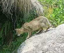 Jungle Cat, seen in Sarmoli Village
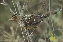 Spotted Laughingthrush in Sarmoli Village
.png.webp) Himalayan Grand Duchess butterfly
Himalayan Grand Duchess butterfly
See also
- Panchchuli - glacier and mountain
- Gori Ganga River
References
- Garhwal-Himalaya-Ost, 1:150,000 scale topographic map, prepared in 1992 by Ernst Huber for the Swiss Foundation for Alpine Research, based on maps of the Survey of India,
- "मुनस्यारी को नगर पंचायत बनाने की मांग मुखर - Amarujala". Amar Ujala (in Hindi). Retrieved 26 May 2018.
- "Decisions taken in the Cabinet meeting on 28th February 2014" (PDF) (in Hindi). Retrieved 26 May 2018.
- "मुनस्यारी नगर पंचायत के गठन की अधिसूचना निरस्त- Amarujala". Amar Ujala (in Hindi). Retrieved 26 May 2018.
- "नगर पंचायत में शामिल नहीं होंगे ग्रामीण". Dainik Jagran (in Hindi). Retrieved 26 May 2018.
- "नगर पंचायत मुनस्यारी के लिए सरकारी कवायद शुरू". Dainik Jagran (in Hindi). Retrieved 26 May 2018.
- Theophilus E, Et Al (2002), A Biodiversity Log And Strategy Input, Document For The Gori River Basin, Western Himalaya Ecoregion District Pithoragarh, Uttaranchal, A Sub-State Process Under The National Biodiversity Strategy And Action Plan India, Foundation For Ecological Security
- BirdLife International (2017) Important Bird Areas factsheet: Askot Wildlife Sanctuary and Goriganga Basin. Downloaded from http://www.birdlife.org on 12/01/2017.
- Birds of Munsiari. Munsiari, Uttarakhand, India: Himal Prakriti - A Trust for Nature. 2014. p. 3.
- "India's 'first' lichen park in Uttarakhand to conserve Jurassic era plant". Times Now. 28 June 2020.
- Punetha, Prem (28 June 2020). "U'khand forest department develops India's first lichen park in Munsyari". Times of India.
External links
| Wikimedia Commons has media related to Munsiyari. |
- Pithoragarh district, official website
- Driving guide to Munsyari
- Natural History Information on Birds from Himal Prakriti