Murara
Murara was a small, short-lived, cinder cone on the flank of Mount Nyamuragira, that began erupting on December 23, 1976. It is located about twelve kilometers south-southwest of the main crater of Nyamuragira.[1] On 18 January 1977, the height of the cone was measured as 150 metres.[2]
| Murara | |
|---|---|
| Highest point | |
| Elevation | less than 3,058 metres (10,033 feet) |
| Coordinates | 1°24′30″S 29°12′0″E |
| Geography | |
| Location | Democratic Republic of the Congo |
| Parent range | Virunga Mountains |
| Geology | |
| Mountain type | Cinder cone |
| Last eruption | 1977 |
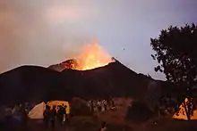
Erupting cinder cone volcano in background, with temporary tourist camp in foreground.
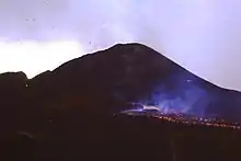
Lava flow in the foreground with the outline of the Murara cinder cone in the background
Eruptions from Murara reduced considerably after the eruption of Mount Nyiragongo on January 10, 1977 and ended completely in April 1977.
During the Christmas and New Year holiday period, the Virunga National Park authorities organised a temporary camp, within a few hundred metres of Murara, so that visitors could observe the eruption and lava flow.
References
- Nakamura, Y.; Aoki, K. (1980). "The 1977 eruption of Nyiragongo volcano, eastern Africa, and chemical composition of the ejecta". Bulletin of the Volcanological Society of Japan (in Japanese). 25 (2): 17–32. doi:10.18940/kazan.25.2_17. (English abstract)(The DOI has not been activated yet.)
- "Report on Nyamuragira (DR Congo) — March 1977". Global Volcanism Program. Smithsonian Institute, National Museum of Natural History. Retrieved 6 February 2021.
- Global Volcanism Program. "Nyamuragira". Washington, D.C.: Department of Mineral Sciences, National Museum of Natural History, Smithsonian Institution.
- "Report on Nyamuragira (DR Congo)". Natural Science Event Bulletin. Smithsonian Institution. 2 (3). March 1977. doi:10.5479/si.GVP.NSEB197703-223020.
This article is issued from Wikipedia. The text is licensed under Creative Commons - Attribution - Sharealike. Additional terms may apply for the media files.
