Muttathody
Muttathody is a village in the Kasaragod district of the Indian state of Kerala. It is located to the east of Kasaragod and to the northwest of Chengala, north of National Highway 66. The village is spread over 12.05 square kilometres (4.65 sq mi) of land.
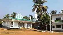
The Pannippara mosque in Muttathody
Muttathody | |
|---|---|
Village | |
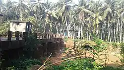 Muttathody bridge | |
| Coordinates: 12°32′30″N 75°1′10″E | |
| Country | |
| State | Kerala |
| District | Kasaragod |
| Area | |
| • Total | 12.05 km2 (4.65 sq mi) |
| Population (2011) | |
| • Total | 20,658 |
| • Density | 1,700/km2 (4,400/sq mi) |
| Languages | |
| • Official | Malayalam, English |
| Time zone | UTC+5:30 (IST) |
| Vehicle registration | KL- |
Demographics
As of 2011, Muttathody had a population of 20,658 people living in 3,846 households. 10,057 of the population were male and 10,601 were female. 3,198 people, or about 15.5% of the population, were at or below the age of 6.[1]
References
- "District Census Handbook - Kasaragod District 2011" (PDF). Directorate of Census Operations-Kerala. 1 October 2011. Retrieved 27 January 2021.
This article is issued from Wikipedia. The text is licensed under Creative Commons - Attribution - Sharealike. Additional terms may apply for the media files.