Kasaragod district
Kasaragod ([kɑːsɾɡoːɖ] (![]() listen) and anglicised to Kassergode) is one of the 14 districts in the southern Indian state of Kerala. It is the northernmost district of Kerala and is included in the North Malabar region. It is also known as Saptha Bhasha Sangama Bhoomi (The land of seven languages), as seven languages namely Malayalam, Tulu, Kannada, Marathi, Konkani, Beary, and Urdu are spoken, unlike the other districts of Kerala.[1] It was a part of the Kannur district of Kerala until 24 May 1984. The district is bounded by Dakshina Kannada district to the north, Western Ghats to the northeast, Kodagu district to the southeast, Kannur district to the south, and Arabian Sea to the west. Kasaragod district has the maximum number of rivers in Kerala - 12.[7]
listen) and anglicised to Kassergode) is one of the 14 districts in the southern Indian state of Kerala. It is the northernmost district of Kerala and is included in the North Malabar region. It is also known as Saptha Bhasha Sangama Bhoomi (The land of seven languages), as seven languages namely Malayalam, Tulu, Kannada, Marathi, Konkani, Beary, and Urdu are spoken, unlike the other districts of Kerala.[1] It was a part of the Kannur district of Kerala until 24 May 1984. The district is bounded by Dakshina Kannada district to the north, Western Ghats to the northeast, Kodagu district to the southeast, Kannur district to the south, and Arabian Sea to the west. Kasaragod district has the maximum number of rivers in Kerala - 12.[7]
Kasaragod
Kasaragod District | |
|---|---|
| Kasaragod | |
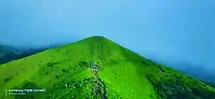  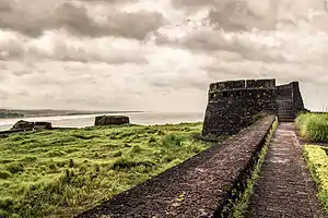 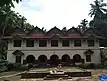 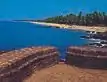 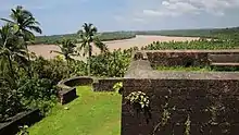 Clockwise from top: Ranipuram, Bekal Fort, Bekal beach, Chandragiri fort, Maipady palace, Chandragiri River at Kanathur near Kasargod. | |
| Nickname(s): The Land of Seven Languages[1] | |
|
Location in Kerala | |
| Coordinates: 12.5°N 75°E | |
| Country | |
| State | Kerala |
| Region | Kolathunadu(southern area) part of North Malabar, Tulu Nadu(northern area) |
| Established | May 1984, 24 |
| Founded by | Government of Kerala |
| Headquarters | Kasaragod |
| Subdistricts | |
| Area | |
| • District | 1,992 km2 (769 sq mi) |
| Population (2018)[2] | |
| • District | 1,390,894 |
| • Density | 698/km2 (1,810/sq mi) |
| • Metro | 1,642,892 |
| Demographics | |
| • Language (2011) | |
| • Religion (2011) |
|
| Human Development | |
| • Sex ratio (2011) | 1080 ♀/1000 ♂[5] |
| • Literacy (2011) | 90.09%[6] |
| Time zone | UTC+5:30 (IST) |
| PIN | 671121 |
| Telephone code | 0499 |
| ISO 3166 code | IN-KL |
| Vehicle registration | KL-14, KL-60, KL-79 |
| Website | kasargod |
History
Ancient period
Kasaragod was a part of ancient Tamilakam in the ancient period. According to the ancient Tamil works of Sangam period, the regions lying in the district was included in Puzhinadu, which had included much of the regions between Kozhikode and Mangalore in the southwestern coast of India. It was a part of Ezhimala kingdom, with its capital at Ezhimala in present-day Kannur district. At the largest extend of its power, the kingdom of Kolathunadu, which later emerged as one of the 4 most powerful kingdoms of Kerala during the medieval period, had extended from Kasaragod in the north to Korapuzha in the south, and Arabian sea in the west to Kodagu Hills in the east.[8]
Medieval period
Kasaragod was known to the Arabs by the name Harkwillia.[9] Many Arab travelers visiting Kerala between the 9th and the 14th centuries visited Kasaragod, being an important trade centre then. Duarte Borbosa, a Portuguese traveler who visited Kumbla, near Kasargod in 1514 recorded that rice being exported for coir to Maldives.[9] According to Barbosa, the people in the southwestern Malabar coast of India from Kumbla in the north to Kanyakumari in the south had spoke a unique language, which they called as "Maliama" (Malayalam).[10] If he is right, then Kumbla would be the northern end of Malayalam region in the first quarter of 16th century CE. Many portions of the present-day Hosdurg taluk(Kanhangad) and Vellarikundu were parts of the Nileshwaram dynasty in the early medieval period. The areas north to the Chandragiri river (present-day Taluks of Manjeshwaram and Kasaragod) was ruled by the Kumbala dynasty, which had 64 Malayalam and Tulu villages according to the legends.[11]
Kannada kingdoms focused on Kasaragod in the 16th century CE. The Vijayanagara empire attacked and annexed Kasaragod from the Kolathiri Raja with Nileshwaram as one of the capital in the 16th century. During the decline of the Vijayanagara empire, the administration of this area was vested with Ikkeri Nayakas.[9] At the onset of collapse of the Vijayanagara empire, Venkappa Nayaka declared independence to Ikkery. Kumbla, Chandragiri, and Bekal are considered to be the chain of forts constructed or renovated by Shivappa Nayaka.[9]
Modern period
Francis Buchanan, the family doctor of Arthur Wellesley, visited Kasaragod in 1800.[9] In his travelogue, he recorded information on places like Athiraparambu, Kavvai, Nileshwaram, Bekal, Chandragiri and Manjeshwar.[9] Hosdurg and Vellarikundu is part of Kolathunadu (south of Chandragiri river) and Kasargod and Manjeshwaram is in the Tulu Nadu region (north of Chandragiri river). In 1763, Hyder Ali conquered Bedanoor (Bidnur), the capital of the Ikkery Naiks. His son Tippu Sultan conquered much of Malabar region in Kerala. As per the Treaty of Seringapatam of 1792, Tippu surrendered Malabar, except Kanara to the British. The British occupied Kanara only after the death of Tippu Sultan.[9] it is said that Kinavoor Molom (Sree Dharma Shashtha Temple) is belonging to Karinthalam (one of 64 Brahmin villages in old Kerala).
Before the formation of Kerala, Kasargod was a part of South Canara district of erstwhile Madras Presidency. However, in 19th century CE, Kasargod Taluk witnessed many struggles to separate the region from South Canara and to merge it with the Malabar District as it was the only Malayalam-majority region in South Canara. Kasargod became a part of Kannur district of Kerala following the reorganization of states and the formation of Kerala on 1 November 1956.[12] Later Kasargod was divided into two Taluks for the ease of administration - Kasargod and Hosdurg. Kasargod was declared a district in the year 1984. The inclusion of Kasaragod with Kerala has been a contentious issue as there is a sizeable population that speaks Tulu and Kannada. But it is noted that as per the 2011 census report only 8.8% and 4.2% of the total population in the district speak Tulu and Kannada respectively as their mother tongue. In 2013, two more Taluks, namely Manjeshwaram and Vellarikundu were formed in the district.
Geography
The district is the northernmost district of the State of Kerala. Kasargod is located at 12.5°N 75.0°E.[13] It has an average elevation of 19 metres (62 feet). Ranipuram or Madathumala (1016m) peak is the highest peak in the Kasargod district of Kerala, located in the Ranipuram Wildlife Sanctuary.
Climate
Kasaragod has a Tropical Climate.
| Climate data for Kasargod | |||||||||||||
|---|---|---|---|---|---|---|---|---|---|---|---|---|---|
| Month | Jan | Feb | Mar | Apr | May | Jun | Jul | Aug | Sep | Oct | Nov | Dec | Year |
| Average high °C (°F) | 33.1 (91.6) |
33.3 (91.9) |
33.9 (93.0) |
34.3 (93.7) |
33.4 (92.1) |
29.8 (85.6) |
28.7 (83.7) |
28.8 (83.8) |
30.1 (86.2) |
31.2 (88.2) |
32.7 (90.9) |
33.1 (91.6) |
31.9 (89.4) |
| Average low °C (°F) | 21.1 (70.0) |
21.9 (71.4) |
23.7 (74.7) |
24.9 (76.8) |
24.9 (76.8) |
23.5 (74.3) |
23 (73) |
23 (73) |
23.2 (73.8) |
23.2 (73.8) |
22.7 (72.9) |
21.3 (70.3) |
23.0 (73.4) |
| Average precipitation mm (inches) | 0.8 (0.03) |
0 (0) |
17.3 (0.68) |
32.7 (1.29) |
182.9 (7.20) |
1,010.5 (39.78) |
1,002.8 (39.48) |
663.6 (26.13) |
246.5 (9.70) |
222.6 (8.76) |
69 (2.7) |
12.4 (0.49) |
3,461.1 (136.24) |
| Source: Meo Weather | |||||||||||||
Administration
Kasargod district consists of two revenue subdivisions- Kasargod and Kanhangad. For sake of rural administration, 38 Gram Panchayats are combined in 6 Block Panchayats, which together form the Kasargod District Panchayat. Besides this in order to perform urban administration better, 3 municipal towns are there.[15]
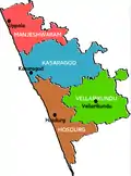
For the representation of Kasargod in Kerala Legislative Assembly, there are 5 assembly constituencies in the district. These are included in the Kasaragod (Lok Sabha constituency).[15][16] The district is further divided into 128 villages which together form 4 subdistricts.[17]
Revenue divisions
Manjeshwaram and Kasargod subdistricts (Taluks) are included in the Kasaragod revenue subdivision whereas the remaining two Taluks are included in the Kanhangad subdivision.
| Subdistrict | Area (in km2) |
Population (2011) |
Villages | |
|---|---|---|---|---|
| Manjeshwaram | 382 | 268,642 | 48 | |
| Kasargod | 594 | 413,092 | 34 | |
| Vellarikundu | 547 | 177,157 | 15 | |
| Hosdurg | 442 | 448,484 | 31 | |
| Sources: 2011 Census of India,[18] Official website of Kasargod district[19] | ||||
State legislature
| Assembly Constituency |
Political Party |
Political Coalition |
Elected Representative |
|---|---|---|---|
| Manjeshwaram | IUML | UDF | M. C. Kamaruddin |
| Kasargod | IUML | UDF | N. A. Nellikkunnu |
| Udma | CPI(M) | LDF | K. Kunhiraman |
| Kanhangad | CPI | LDF | E. Chandrasekharan |
| Thrikaripur | CPI(M) | LDF | M. Rajagopalan |
Parliament
| Parliamentary Constituency |
Political Party |
Political Coalition |
Elected Representative |
|---|---|---|---|
| Kasargod | INC | UDF | Rajmohan Unnithan |
Demographics
According to the 2018 Vital Statistics published by the Government of Kerala, Kasargod district has a population of 1,390,894,[2] roughly equal to the nation of Trinidad and Tobago[21] or the US state of New Hampshire.[22] The 2011 Census of India, gives the district a ranking of 375th in India (out of a total of 640).[23] The district has a population density of 654 inhabitants per square kilometre (1,690/sq mi) .[23] Its population growth rate over the decade 2001–2011 was 8.18%.[23] Kasaragod has a sex ratio of 1080 females for every 1000 males,[23] and a literacy rate of 90.09%.[24] The Kerala Tulu Academy, which promotes Tulu language and literature, is functioned at Hosangadi in the district.
| Year | Pop. | ±% p.a. |
|---|---|---|
| 1901 | 231,280 | — |
| 1911 | 247,467 | +0.68% |
| 1921 | 256,931 | +0.38% |
| 1931 | 302,043 | +1.63% |
| 1941 | 342,301 | +1.26% |
| 1951 | 411,031 | +1.85% |
| 1961 | 512,146 | +2.22% |
| 1971 | 683,020 | +2.92% |
| 1981 | 872,741 | +2.48% |
| 1991 | 1,071,508 | +2.07% |
| 2001 | 1,204,078 | +1.17% |
| 2011 | 1,307,375 | +0.83% |
| 2018 | 1,390,894 | +0.89% |
| source:[25] | ||
Education

Tourism
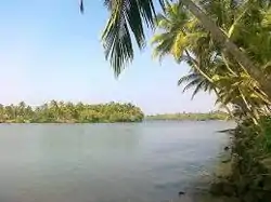
- Bekal Fort[26]
- Malik Dinar Mosque
- Chandragiri Fort[27]
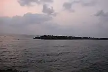
- Edayilakkad Island[28]
- Kanwatheertha beach
- Kappil beach[29]
- Kottanchery hills
- Mayipady palace[30]
- Pallikkara beach
- Ranipuram Hill Station
- Ananthapuram Lake Temple
- Our Lady of Sorrows Church
- Valiyaparamba Island
Notable people
- Ambikasuthan Mangad - a Malayalam writer.
- Anil Kumble - Former Indian cricketer, coach, and commentator.
- Arya - an Indian actor.
- Asif Kottayil - an Indian footballer.
- Bellikoth Raghunath Shenoy - an Indian economist.
- D. K. Chowta - an Indian businessman.
- E. Chandrasekharan - a minister of Kerala.
- Harikumar Pallathadka - an RTI activist.
- K. K. Venugopal - Attorney General of India.
- Kanayi Kunhiraman - an Indian artist.
- Mavila Vishwanathan Nair - an Indian banker.
- Mirshad Michu - an Indian footballer.
- Mohammed Rafi - an Indian footballer.
- Mohammed Azharuddeen - an Indian cricketer.
- P. Kunhiraman Nair - a Malayalam poet.
- Pallathadka Pramoda Kumari - a scientist.
- Pramod Raman - a Malayalam journalist.
- Santhosh Echikkanam - a Malayalam short story writer.
- Sara Aboobacker - a Kannada writer.
References
- "Kasargod - the land of seven languages". invest kerala. Government of Kerala. Retrieved 12 September 2020.
- Annual Vital Statistics Report - 2018 (PDF). Thiruvananthapuram: Department of Economics and Statistics, Government of Kerala. 2020. p. 55.
- "Language – Kerala, Districts and Sub-districts". Census of India 2011. Office of the Registrar General.
- "Religion – Kerala, Districts and Sub-districts". Census of India 2011. Office of the Registrar General.
- "Sex Ratio" (PDF). censusindia.gov.in.
- "Literacy" (PDF). censusindia.gov.in.
- "Rivers in Kasargod". Kerala Tourism. Retrieved 12 September 2020.
- District Census Handbook, Kasaragod (2011) (PDF). Thiruvananthapuram: Directorate of Census Operation, Kerala. p. 9.
- "Kasaragod History". Government of Kerala. Archived from the original on 25 September 2008. Retrieved 11 March 2009.
- Barbosa, Duarte (1989). The Book of Duarte Barbosa: An Account of the countries bordering on the Indian Ocean and their inhabitants (Volume 2). Asian Educational Services. pp. 1–7. ISBN 9788120604513.
- Sreedhara Menon, A. A Survey of Kerala History (2007 ed.). Kottayam: DC Books. ISBN 9788126415786.
- "Kasargod After District Formation". Kasargod District. Archived from the original on 10 April 2009. Retrieved 11 March 2009.
- Falling Rain Genomics, Inc - Kasaragod
- "Municipalities in Kasaragod". Official website of Kasaragod district. Retrieved 12 September 2020.
- "Administrative divisions of Kasaragod district". Official website of Kasaragod district. Retrieved 12 September 2020.
- "Niyamasabha constituencies of Kasargod". ceo.kerala.gov.in. Retrieved 12 September 2020.
- "Talukas in Kasargod district". Kasargod district website. Retrieved 12 September 2020.
- "Taluk-wise demography of Kasargod" (PDF). censusindia.gov.in. Directorate of Census Operations, Kerala. pp. 79–98. Retrieved 12 September 2020.
- "Villages in Kasargod". kasargod.nic.in. Retrieved 12 September 2020.
- "Census of India - Language". censusindia.gov.in. Retrieved 17 April 2020.
- US Directorate of Intelligence. "Country Comparison:Population". Retrieved 1 October 2011.
Mauritius 1,303,717 July 2011 est.
- "2010 Resident Population Data". U. S. Census Bureau. Archived from the original on 1 January 2011. Retrieved 30 September 2011.
New Hampshire 1,316,470
- "District Census 2011". Census2011.co.in. 2011. Retrieved 30 September 2011.
- "Literacy and Sex Ratio - 2011" (PDF). censusindia.gov.in.
- Decadal Variation In Population Since 1901
- Simran Gill (14 June 2020). "5 Lesser Known Forts in India". Outlook India. Retrieved 12 September 2020.
- Divakaran, Kattakada (2005). Kerala Sanchaaram. Thiruvananthapuram: Z Library. p. 925.
- "Proposal Submitted to Government of India: Integrated Coastal Zone Management" (PDF). sisem.in. Government of Kerala. 2015. p. 60. Retrieved 12 September 2020.
The area has rich biodiversity. The sacred grove viz. Edayilakkad island preserves many rare and endemic species.
- Vishnu Mohan (27 July 2020). "6 Lesser-Known Places in Kerala for a Weekend Break". Outlook India. Retrieved 12 September 2020.
- Giridhar Khasnis (17 May 2015). "Finding everland". Deccan Herald. Retrieved 12 September 2020.
External links
| Wikimedia Commons has media related to Kasaragod district. |
| Wikivoyage has a travel guide for Kasaragod District. |