Kasaragod
Kasaragod or Kaasrodu is a municipal town and administrative headquarters of Kasaragod district of Kerala state in India. Situated in the rich biodiversity of Western Ghats, it is known for the Chandragiri and Bekal Forts,[2] Chandragiri River, historic Kolathiri Rajas, natural environment of Ranipuram and Kottancheri Hills, historical and religious sites like the Madiyan Kulom temple, Madhur Temple, Ananthapuram Lake Temple and Malik Deenar Mosque. It is located 50 km south of the major port city & a commercial hub Mangalore and 578 km north of state capital Thiruvananthapuram.
Kasaragod | |
|---|---|
City | |
| Kasaragod | |
| Nickname(s): Kaasrodu | |
 Kasaragod Location of Kasaragod in Kerala  Kasaragod Kasaragod (India)  Kasaragod Kasaragod (Asia) .svg.png.webp) Kasaragod Kasaragod (Earth) | |
| Coordinates: 12.5°N 75.0°E | |
| Country | |
| State | Kerala |
| Regions | North Malabar |
| District | Kasaragod |
| Government | |
| • Type | District |
| • Body | Kasaragod Municipality |
| Area | |
| • City | 16.7 km2 (6.4 sq mi) |
| • Metro | 93.3 km2 (36.0 sq mi) |
| Elevation | 19 m (62 ft) |
| Population | |
| • City | 54,172 |
| • Density | 3,200/km2 (8,400/sq mi) |
| • Metro | 192,856 |
| Languages | |
| • Official | Malayalam, English,[1] |
| Time zone | UTC+5:30 (IST) |
| PIN | 671121 |
| Telephone | 91–04994 |
| Vehicle registration | KL-14 |
| Website | kasargod |
Politics
The major political parties are CPI(M), CPI, Indian Union Muslim League, INC and BJP. North Kasaragod is dominated by BJP and IUML, and the south is dominated by CPI(M). N.A. Nellikkunnu is the present Member of Legislative Assembly, Kerala Legislature. Kasaragod assembly constituency is part of Kasaragod (Lok Sabha constituency). Indian National Congress [INC] member Rajmohan Unnithan is the present MP from Kasaragod [2019 Elections].[3]
Science and research
Kasaragod is home to the Central Plantation Crops Research Institute, originally established in 1916 as the Coconut Research Station. It is part of India's National Agricultural Research System under the Indian Council of Agricultural Research.[4] According to the Institute, Kerala "lies in the heart of the major coconut growing areas of the country." It is also home to the Indian Society for Plantation Crops, which publishes the Journal of Plantation Crops and holds symposiums on the subject.[5] The Central University of Kerala is also located in Kasargod(Periya hills).
Demographics
Languages
Religions
Kasaragod town constitutes major chunk of Muslims and Hindus followed by Christians, Jains and other minorities.
Religions in Kasaragod city
Image gallery
 Malik Dinar Mosque is one of the oldest mosques in India
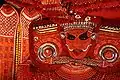 Theyyam is a popular ritual form of dance worship in Kasaragod
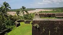 Chandrigiri Fort Melparamba, is 6 Kilometre away from Kasaragod town
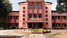 Govt College Kasaragod Front view
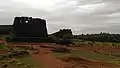 Bekal Fort is the top tourist spot in Kasaragod. Bekal fort and Bekal fort beach (Pallikkara beach) is one of the finest tourist destination in Kerala. There are luxurious hotels and beach resorts are surrounding Bekal Fort.
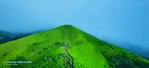 Ranipuram is a hill station and a major tourist attraction in the Kasaragod district
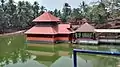 Ananthapuram Lake Temple is a Hindu temple built in the middle of a lake in the little village of Ananthapura, around 6 km from the town of Kumbla in Manjeswaram taluk. This is the only lake temple in Kerala.
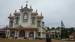 Bela Church, also known as Our Lady of Sorrows Church, is a Roman Catholic church which is15 km north of Kasaragod Municipal Town
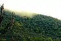 Malom Wildlife Sanctuary is all about lush green tropical green forest and variety of wildlife. The sanctuary inhabits a variety of animals and birds including peacock, the Malabar hornbill, wild pig, flying squirrel, rhesus monkey and porcupine etc. If you are lucky, you may also get to see king Cobra and Python.
 Valiyaparamba is a coastal island in Hosdurg taluk, Kasaragod district. It is a beautiful backwater destination, it is a favorite spot for tourists seeking seclusion. The lush green groves and emerald green waters add on to the beauty of this landscape.
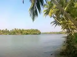 Edayilakkad is a marshy island situated in Valiyaparamba Panchayath, Kasaragod district, Kerala, India. It is located in the Kavvayi Backwaters, the arm of the Arabian Sea. Edayilakkad is noted for its biodiversity and local conservation efforts.
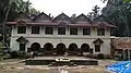 Maipadi Palace is situated on Kasaragod-Perla road, about 8 km from Kasaragod Municipal town. The palace was once the seat of the Kumbala Kings
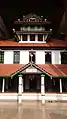
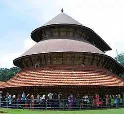 Madhur Temple is a popular Shiva and Ganapathi temple located 7 km (4.3 mi) from Kasaragod town, on the banks of Mogral river, locally known as Madhuvahini
Climate
Kasaragod experiences a Tropical monsoon climate under the Köppen climate classification. It receives a generous 3,825 mm (150.6 in) of rain annually.
| Climate data for Kasaragod, Kerala | |||||||||||||
|---|---|---|---|---|---|---|---|---|---|---|---|---|---|
| Month | Jan | Feb | Mar | Apr | May | Jun | Jul | Aug | Sep | Oct | Nov | Dec | Year |
| Average high °C (°F) | 31.4 (88.5) |
31.5 (88.7) |
32.2 (90.0) |
32.7 (90.9) |
32.2 (90.0) |
29.3 (84.7) |
28.2 (82.8) |
28.4 (83.1) |
28.8 (83.8) |
30.0 (86.0) |
31.0 (87.8) |
31.5 (88.7) |
30.6 (87.1) |
| Average low °C (°F) | 21.7 (71.1) |
22.8 (73.0) |
24.3 (75.7) |
25.9 (78.6) |
25.7 (78.3) |
23.9 (75.0) |
23.4 (74.1) |
23.6 (74.5) |
23.5 (74.3) |
23.8 (74.8) |
23.1 (73.6) |
22.0 (71.6) |
23.6 (74.6) |
| Average precipitation mm (inches) | 1 (0.0) |
1 (0.0) |
5 (0.2) |
55 (2.2) |
262 (10.3) |
1,002 (39.4) |
1,190 (46.9) |
647 (25.5) |
338 (13.3) |
229 (9.0) |
77 (3.0) |
18 (0.7) |
3,825 (150.5) |
| Source: Climate-Data.org[7] | |||||||||||||
See also
- Kasaragod East
- Kuloor
- List of educational institutions in Kasaragod District
- List of tourist attractions in Kasaragod
References
- "The Kerala Official Language (Legislation) Act, 1969" (PDF).
- "Draft Map" (PDF). keralaczma.gov.in. 2012. Retrieved 22 January 2021.
- "Kasaragod Parliament Constituency". Kerala. Election Commission of India. Archived from the original on 21 June 2008. Retrieved 18 October 2009.
- "About Institute". CPCRI.in. Central Plantation Crops Research Institute. Retrieved 25 January 2016.
The Coconut Research Station at Kasaragod in Kerala was initially established in 1916 by the then Government of Madras and subsequently it was taken over by the Indian Central Coconut Committee in 1948
- "Indian Society for Plantation Crops". indsocplantationcrops.in. Indian Society for Plantation Crops. Retrieved 25 January 2016.
- "Census of India - Language". censusindia.gov.in. Retrieved 17 April 2020.
- "CLIMATE: KASARAGOD", Climate-Data.org. Web: .
External links
| Wikimedia Commons has media related to Kasaragod. |
 Kasaragod travel guide from Wikivoyage
- "Places to Visit in Kasargod", Tripoto, retrieved 2 November 2014
- C.P.C.R.I
- CPCRI
- Official Website of the District Administration
- https://invest.kerala.gov.in/?district=kasaragodFile:..Kerala+Flag(INDIA).png+State+of+KeralaCapital:+ThiruvananthapuramDistricts+Thiruvananthapuram+KL-01+Kollam+KL-02+Pathanamthitta+KL-03+Alappuzha+KL-04+Kottayam+KL-05+Idukki+KL-06+Ernakulam+KL-07+Thrissur+KL-08+Palakkad+KL-09+Malappuram+KL-10+Kozhikode+KL-11+Wayanad+KL-12+Kannur+KL-13+Kasaragod+KL-14Topics+Arts+Culture+Demographics+Economy+Education+Film+Geography++Roads++Ports+History+Wildlife+Government+Tourism+SportsSymbolsBird+Great+hornbillAnimal+Indian+elephantTree+CoconutFlower+Golden+rainFish+KarimeenFruitJackfruitInsectPapilio+buddhaTaluks+Adoor+Alathur+Aluva+Ambalappuzha+Chalakudy+Changanassery+Chavakkad+Chengannur+Cherthala+Chirayinkeezhu+Chittur+Devikulam+Eranad+Hosdurg+Idukki+Iritty+Kanayannur+Kanjirappally+Kannur+Karthikappally+Karunagappalli+Kasaragod+Kattakada+Kochi+Kodungallur+Kollam+Kondotty+Konni+Kothamangalam+Kottarakkara+Kottayam+Koyilandy+Kozhencherry+Kozhikode+Kunnamkulam+Kunnathunad+Kunnathur+Kuttanad+Mallapally+Mananthavady+Manjeshwaram+Mannarkkad+Mavelikkara+Meenachil+Mukundapuram+Muvattupuzha+Nedumangad+Neyyattinkara+Nilambur+North+Paravur+Ottapalam+Palakkad+Pathanapuram+Pattambi+Payyanur+Peermade+Perinthalmanna+Ponnani+Punalur+Ranni+Sultan+Bathery+Taliparamba+Thalapilly+Thalassery+Thamarassery+Thiruvalla+Thiruvananthapuram+Thodupuzha+Thrissur+Tirur+Tirurangadi+Udumbanchola+Vaikom+Varkala+Vatakara+Vellarikundu+VythiriMunicipal+Corporations+Thiruvananthapuram+Kozhikode+Kochi+Kollam+Thrissur+KannurMunicipalities+Adoor+Anthoor+Alappuzha+Aluva+Angamaly+Attingal+Chalakudy+Changanassery+Chavakkad+Chengannur+Cherthala+Chittur-Thathamangalam+Eloor+Guruvayur+Irinjalakuda+Iritty+Kalamassery+Kalpetta+Kanhangad+Karunagappalli+Kasaragod+Kayamkulam+Kodungallur+Kondotty+Kuthuparamba+Kothamangalam+Kottakkal+Kottarakkara+Kottayam+Koyilandy+Kunnamkulam+Malappuram+Manjeri+Maradu+Mattanur+Mavelikkara+Muvattupuzha+Nedumangad+Neyyattinkara+Nilambur+Nileshwaram+North+Paravur+Ottapalam+Pala+Palakkad+Panoor+Parappanangadi+Paravur+Pathanamthitta+Payyanur+Perinthalmanna+Perumbavoor+Ponnani+Punalur+Shoranur+Sreekandapuram+Tanur+Thalassery+Taliparamba+Thiruvalla+Thodupuzha+Thrikkakkara+Thrippunithura+Tirur+Tirurangadi+Valanchery+Vatakara+Vaikom+VarkalaOther+townsNorth+Edappal+Tavanur++Angadipuram+Mankada+Kuttippuram+Karipur+Areekode+Wandoor+Vengara++Vallikkunnu++Olavanna+Kunnamangalam++Thamarassery++Thiruvambady++Kodencheri++Balussery++Perambra++Nadapuram++Kuttiady+Lakkidi+++Vythiri++Chundale+Meppadi+Kottappadi+Muttil++Padinharethara+Meenangadi++Panamaram++Pulpally++Peravoor+Dharmadom+Anjarakkandy+Muzhappilangad+Azhikode+Cherukunnu+Pappinisseri+Kalliasseri+Irikkur+Alakode+Trikaripur+Cheruvathur+Bekal+Udma+Vellarikundu+Parappa+Karadka+Kumbla+Mangalpady+Uppala+ManjeshwarCentral+Peermade+Vandiperiyar+Kumily+Rajakkad+Munnar+Devikulam+Adimali+Kolenchery+Puthencruz+Kunnathunad+Kalady+Malayattoor+Chottanikkara+Udayamperoor+Varappuzha+Sreemoolanagaram+Nedumbassery+Mala+Kodakara+Puthukkad+Manaloor+Pavaratty+Chelakkara+Vadakkencherry+Alathur+Nemmara+Puthunagaram+Malampuzha+Sreekrishnapuram+Lakkidi-Perur+ThrithalaSouth+Parassala+Balaramapuram+Kattakada+Chirayinkeezhu+Kilimanoor+Parippally+Chathannoor+Kottiyam+Kundara+Neendakara+Chavara+Oachira+Sasthamkotta+Kunnathur+Anchal+Kadakkal+Pathanapuram+Thenmala+Kulathupuzha+Kozhencherry+Konni+Ranni+Mallapally+Kumbanad+Aranmula+Kulanada+Omallur+Vadasserikara+Parumala+Mannar+Charummoodu+Ambalappuzha+Mararikulam+Aroor+Kanjirappally+Erumely+Mundakayam+Vazhoor+Karukachal+Pampady+Puthuppally+Kuravilangad+Uzhavoor+Thalayolaparambu+KaduthuruthyHistorical+regions+Kolathunadu+(Kingdom+of+Cannanore)+Nediyiruppu+Swaroopam+(Kingdom+of+Calicut)++Malabar+North+Malabar+South+Malabar+Cochin+Venad+Swarupam+(Kingdom+of+Quilon)+Travancore+Travancore-CochinFile:Flag+of+India.svg
.png+State+of+KeralaCapital:+ThiruvananthapuramDistricts+Thiruvananthapuram+KL-01+Kollam+KL-02+Pathanamthitta+KL-03+Alappuzha+KL-04+Kottayam+KL-05+Idukki+KL-06+Ernakulam+KL-07+Thrissur+KL-08+Palakkad+KL-09+Malappuram+KL-10+Kozhikode+KL-11+Wayanad+KL-12+Kannur+KL-13+Kasaragod+KL-14Topics+Arts+Culture+Demographics+Economy+Education+Film+Geography++Roads++Ports+History+Wildlife+Government+Tourism+SportsSymbolsBird+Great+hornbillAnimal+Indian+elephantTree+CoconutFlower+Golden+rainFish+KarimeenFruitJackfruitInsectPapilio+buddhaTaluks+Adoor+Alathur+Aluva+Ambalappuzha+Chalakudy+Changanassery+Chavakkad+Chengannur+Cherthala+Chirayinkeezhu+Chittur+Devikulam+Eranad+Hosdurg+Idukki+Iritty+Kanayannur+Kanjirappally+Kannur+Karthikappally+Karunagappalli+Kasaragod+Kattakada+Kochi+Kodungallur+Kollam+Kondotty+Konni+Kothamangalam+Kottarakkara+Kottayam+Koyilandy+Kozhencherry+Kozhikode+Kunnamkulam+Kunnathunad+Kunnathur+Kuttanad+Mallapally+Mananthavady+Manjeshwaram+Mannarkkad+Mavelikkara+Meenachil+Mukundapuram+Muvattupuzha+Nedumangad+Neyyattinkara+Nilambur+North+Paravur+Ottapalam+Palakkad+Pathanapuram+Pattambi+Payyanur+Peermade+Perinthalmanna+Ponnani+Punalur+Ranni+Sultan+Bathery+Taliparamba+Thalapilly+Thalassery+Thamarassery+Thiruvalla+Thiruvananthapuram+Thodupuzha+Thrissur+Tirur+Tirurangadi+Udumbanchola+Vaikom+Varkala+Vatakara+Vellarikundu+VythiriMunicipal+Corporations+Thiruvananthapuram+Kozhikode+Kochi+Kollam+Thrissur+KannurMunicipalities+Adoor+Anthoor+Alappuzha+Aluva+Angamaly+Attingal+Chalakudy+Changanassery+Chavakkad+Chengannur+Cherthala+Chittur-Thathamangalam+Eloor+Guruvayur+Irinjalakuda+Iritty+Kalamassery+Kalpetta+Kanhangad+Karunagappalli+Kasaragod+Kayamkulam+Kodungallur+Kondotty+Kuthuparamba+Kothamangalam+Kottakkal+Kottarakkara+Kottayam+Koyilandy+Kunnamkulam+Malappuram+Manjeri+Maradu+Mattanur+Mavelikkara+Muvattupuzha+Nedumangad+Neyyattinkara+Nilambur+Nileshwaram+North+Paravur+Ottapalam+Pala+Palakkad+Panoor+Parappanangadi+Paravur+Pathanamthitta+Payyanur+Perinthalmanna+Perumbavoor+Ponnani+Punalur+Shoranur+Sreekandapuram+Tanur+Thalassery+Taliparamba+Thiruvalla+Thodupuzha+Thrikkakkara+Thrippunithura+Tirur+Tirurangadi+Valanchery+Vatakara+Vaikom+VarkalaOther+townsNorth+Edappal+Tavanur++Angadipuram+Mankada+Kuttippuram+Karipur+Areekode+Wandoor+Vengara++Vallikkunnu++Olavanna+Kunnamangalam++Thamarassery++Thiruvambady++Kodencheri++Balussery++Perambra++Nadapuram++Kuttiady+Lakkidi+++Vythiri++Chundale+Meppadi+Kottappadi+Muttil++Padinharethara+Meenangadi++Panamaram++Pulpally++Peravoor+Dharmadom+Anjarakkandy+Muzhappilangad+Azhikode+Cherukunnu+Pappinisseri+Kalliasseri+Irikkur+Alakode+Trikaripur+Cheruvathur+Bekal+Udma+Vellarikundu+Parappa+Karadka+Kumbla+Mangalpady+Uppala+ManjeshwarCentral+Peermade+Vandiperiyar+Kumily+Rajakkad+Munnar+Devikulam+Adimali+Kolenchery+Puthencruz+Kunnathunad+Kalady+Malayattoor+Chottanikkara+Udayamperoor+Varappuzha+Sreemoolanagaram+Nedumbassery+Mala+Kodakara+Puthukkad+Manaloor+Pavaratty+Chelakkara+Vadakkencherry+Alathur+Nemmara+Puthunagaram+Malampuzha+Sreekrishnapuram+Lakkidi-Perur+ThrithalaSouth+Parassala+Balaramapuram+Kattakada+Chirayinkeezhu+Kilimanoor+Parippally+Chathannoor+Kottiyam+Kundara+Neendakara+Chavara+Oachira+Sasthamkotta+Kunnathur+Anchal+Kadakkal+Pathanapuram+Thenmala+Kulathupuzha+Kozhencherry+Konni+Ranni+Mallapally+Kumbanad+Aranmula+Kulanada+Omallur+Vadasserikara+Parumala+Mannar+Charummoodu+Ambalappuzha+Mararikulam+Aroor+Kanjirappally+Erumely+Mundakayam+Vazhoor+Karukachal+Pampady+Puthuppally+Kuravilangad+Uzhavoor+Thalayolaparambu+KaduthuruthyHistorical+regions+Kolathunadu+(Kingdom+of+Cannanore)+Nediyiruppu+Swaroopam+(Kingdom+of+Calicut)++Malabar+North+Malabar+South+Malabar+Cochin+Venad+Swarupam+(Kingdom+of+Quilon)+Travancore+Travancore-CochinFile:Flag+of+India.svg )