Nána, Slovakia
Nána (Hungarian: Nána) is a village and municipality in the Nové Zámky District in the Nitra Region of south-west Slovakia, near the border with Hungary.
Nána | |
|---|---|
Municipality | |
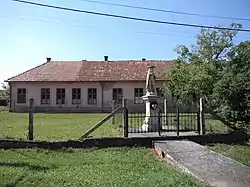 Statue of Saint Wendelin | |
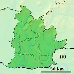 Nána Location of Nána in the Nitra Region  Nána Location of Nána in Slovakia | |
| Coordinates: 47°49′N 18°43′E | |
| Country | Slovakia |
| Region | Nitra |
| District | Nové Zámky |
| First mentioned | 1157 |
| Government | |
| • Mayor | Dezider Molnár[1] |
| Area | |
| • Total | 17.947 km2 (6.929 sq mi) |
| Elevation | 110 m (360 ft) |
| Population (2019) | |
| • Total | 1,223 |
| • Density | 68/km2 (180/sq mi) |
| Postal code | 943 60 |
| Car plate | NZ |
History
In historical records the village was first mentioned in 1157.[2]
Geography
The municipality lies at an elevation of 110 metres (360 ft) and covers an area of 17.947 km² (6.929 mi²).[3]
Demographics
In 2011, the municipality had a population of 1223 people.[4] 70% of the population identified as Hungarian and 24% as Slovak. It has a small Romani minority.
Facilities
The village has a small public library and a football pitch.
References
External links
This article is issued from Wikipedia. The text is licensed under Creative Commons - Attribution - Sharealike. Additional terms may apply for the media files.
