N305 highway (Philippines)
The National Route 305 (N305) forms a part of the Philippine highway network. It is a secondary road that acts as a four-lane spur road that spans 1.7 kilometers (1.1 mi) and consists two major streets in Olongapo, serving as the main road of Olongapo city proper.
| ||||
|---|---|---|---|---|
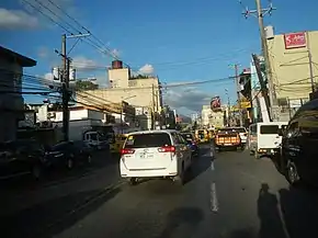 The Rizal Avenue segment of N305 (northbound) in Olongapo. The Ulo ng Apo roundabout intersection can be seen in the background as its northern terminus. | ||||
| Route information | ||||
| Maintained by the Department of Public Works and Highways | ||||
| Length | 1.7 km[1] (1.1 mi) | |||
| Major junctions | ||||
| North end | ||||
| South end | Magsaysay Bridge (pedestrian walkway) | |||
| Location | ||||
| Provinces | Zambales | |||
| Major cities | Olongapo | |||
| Highway system | ||||
| ||||
.svg.png.webp)
Route description
Route N305 was constructed by the United States Government when the Olongapo was a Naval Reservation. U.S. navy personnel was used the route to provide access going to Manila while the U.S. Naval Base Subic Bay exist in Olongapo.
Magsaysay Drive
N305 starts at the Magsaysay Bridge as its southern terminus, a pedestrian walkway where it used to be a roadway for vehicles that provides access to the Subic Bay Freeport Zone until 2011 when SM City Olongapo was built. The route is entirely a one-way road for northbound vehicles. Magsaysay Drive ends at the Friendship Rotunda, a roundabout intersection that was built in the 1970s.
Rizal Avenue
Going further north, N305 continues the route after the Friendship Rotunda, as Rizal Avenue. the Bajac-Bajac Bridge also crosses the route. N305 terminates north at the Ulo ng Apo roundabout – intersecting with other major roads of Jose Abad Santos Avenue (N3) and Olongapo–Bugallon Road (N306).
Maintenance
N305 was maintain by the City Government of Olongapo and the Department of Public Works and Highways.
Enforcement
The route was equipped with CCTV camera, traffic cones and proper traffic signage to provide safety features and guide direction for motorist. the whole route has assigned traffic personnel enforced by Office of the Traffic Management and Public Safety.
Intersections
Rizal Avenue
- Sta Rita Intersection
- 26th Street West Junction
- 25th Street (OCES) West Junction
- 24th Street Intersection
- 23rd Street (City Hall) West Junction
- 22nd Street East Junction
- Rizal Triangle Junction
- 20th Street Intersection
- Ulo ng Apo Rotunda
Rizal Avenue Extension
- Hospital Road - Anonas Street Intersection (known as SM City Olongapo Central Intersection)
- 16th Street Intersection
- 14th Street (Jackson) Intersection
- 12th Street Intersection
- 11th Street West Junction
- 9th Street (Wesley) Intersection
- Friendship Rotunda
Magsaysay Drive (North to South)
- Fendler Street Intersection
- Gallagher Street East Junction
- Hansen - 3rd Street Intersection (Police Station 3)
- Gordon Avenue - 1st Street Intersection (Magsaysay Drive Main Crossing)
- Main Gate - Columban Junction (end of Magsaysay Drive)
References
- "Road and Bridge Inventory". www.dpwh.gov.ph. Retrieved 2020-08-27.
| National primary roads |
| |||||||
|---|---|---|---|---|---|---|---|---|
| National secondary roads |
| |||||||
See also: Philippine expressway network | ||||||||