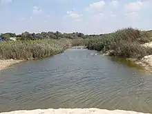
Nahal Poleg
Nahal Poleg (Hebrew: נחל פולג) is a stream in the Sharon plain in Israel that empties into the Mediterranean Sea between Netanya and the Wingate Institute.
Geography
The stream starts between Tira and Ramat HaKovesh, east of Mishmeret. It runs west to the sea, veering north at Batzra. It is mostly intermittent, and becomes a perennial stream towards its end. There is a man-made opening in the kurkar ridge that runs south-north along the coastal plain.
History
In Arabic, the stream had been known as نهر الفالق Nahr al-Faliq, alternatively transliterated as Nahr Falaik;[1] and later as وادي الفالق Wadi al-Faliq.

The nearby Tel Poleg archaeological site was excavated, revealing a fortified city of the Middle Bronze Age. The site has mostly been destroyed by a modern quarry. The original opening in the kurkar ridge was made in the Bronze Age, and reopened during the Roman period.[2] By the thirteenth century CE, the opening was clogged, resulting in a 4000-dunam marsh. The opening was cleared again in 1935, and the stream's current course was set in the area east of the kurkar ridge.[3]
The Crusaders called the stream River Rochetaillé ("Split-rock River") because of the long narrow rock channel, cut artificially at some former period through the inland cliffs, by which the river finds a channel to the sea shore.[4]
Nature Reserve
The Nahal Poleg nature reserve is situated between Wingate Institute and Ramat Poleg, between Highway 2 and the Mediterranean.[5] It covers 500 dunams, and was declared a reserve in 1971.[6]
Flora in the reserve includes a coastal variety of Boxthorn, Ephedra aphylla, Calicotome villosa, the endemic Rumex rothschildianus, Iris atropurpurea, Lupin, and Tulipa agenensis sharonensis.
References
- Charles Oman (1924). A History of the Art of War in the Middle Ages. 1. London: Methuen Publishing. pp. 308, 311.
- נחל פולג - פארק יקום - מידע למטייל [Nahal Poleg - Park Yakum - Visitor's Information] (in Hebrew). Trekker.co.il.
- שמורות הפולג [The Poleg Reserve] (in Hebrew). Israel Nature and Parks Authority. Archived from the original on 2012-03-14. Retrieved 2010-10-30.
- Claude R. Conder (29 January 1875). "XXXI. Mediæval Topography of Palestine.". Quarterly Statement for 1875. London: Palestine Exploration Fund. p. 92.
- "Nahal Poleg Reserve" (in Hebrew). iNature.info. Retrieved 2010-10-30.
- "List of National Parks and Nature Reserves" (PDF) (in Hebrew). Israel Nature and Parks Authority. Archived from the original (PDF) on 2012-03-13. Retrieved 2010-09-27.
External links
| Wikimedia Commons has media related to Poleg Stream. |
| Jerusalem District |
| ||||||||||
|---|---|---|---|---|---|---|---|---|---|---|---|
| Northern District |
| ||||||||||
| Haifa District |
| ||||||||||
| Central District | |||||||||||
| Southern District |
| ||||||||||
| Judea and Samaria Area |
| ||||||||||
See also: National parks of Israel | |||||||||||