Nahr al-Kabir al-Shamali
Nahr al-Kabir al-Shamali (Arabic: النهر الكبير الشمالي, lit. 'the northern great river') is a river in Latakia Governorate, Syria.
| Nahr al-Kabir al-Shamali Arabic: النهر الكبير الشمالي | |
|---|---|
 | |
| Location | |
| Country | Syria |
| Physical characteristics | |
| Source | Syrian Coastal Mountain Range |
| • location | Latakia Governorate, Syria |
| • elevation | 1,100 m (3,600 ft) |
| Mouth | south of Latakia |
| Length | 56 km (35 mi) |
| Basin size | 1,103.63 km2 (426.11 sq mi) |
| Discharge | |
| • average | 40 m3/s (1,400 cu ft/s) |
Course
Al-Kabir al-Shamali river rises in the Syrian Coastal Mountain Range, north western Syria at the Turkish borders, and runs through a plain area to the south west to finally flow into the Mediterranean Sea south of Latakia.
Dams
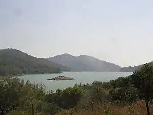
- 16 Tishreen dam, built to be used in power generation, storage of rain and river water, and the creation of Mashqita lake for fishing and tourism.[2]
- Baradun Dam, is another dam under construction on the river to the north of the previous one.[3] However, the construction was halted during the Syrian Civil War.[4]
References
- The City of Ugarit at Tell Ras Shamra. Eisenbrauns. 2006. p. 9. ISBN 9781575060293.
- "المراقبة والإدارة البیئیة لنھر الكبیر الشمالي" (PDF) (in Arabic). Archived from the original (PDF) on 2016-12-20. Retrieved 2016-12-15.
- "سوريا: بدء العمل بسد برادون في اللاذقية بتكلفة 2.768 مليار ليرة". albawaba.com (in Arabic). 28 February 2005.
- "فيديو.. خطوات لإعادة افتتاح سد برادون بريف اللاذقية الشمالي". alalamtv.net (in Arabic). 19 October 2017.
This article is issued from Wikipedia. The text is licensed under Creative Commons - Attribution - Sharealike. Additional terms may apply for the media files.
